the Creative Commons Attribution 4.0 License.
the Creative Commons Attribution 4.0 License.
 | 24 Nov 2022
South American 2020 regional smoke plume: intercomparison with previous years, impact on solar radiation, and the role of Pantanal biomass burning season
Nilton Évora do Rosário
Elisa Thomé Sena
Marcia Akemi Yamasoe
The 2020 biomass burning season in Brazil was marked by an atypical amount of fire across the Pantanal biome, which led to high levels of smoke within the biome and downwind areas. The present study analyzes fire counts and smoke over Pantanal in 2020, comparing this particular year's data with those from the previous 17 years (2003–2019). Taking as reference the most-polluted years in this period, the regional smoke plume and its impact on surface solar radiation were also evaluated. In 2020, the regional smoke plume core covered an area of ∼ 2.6×10⁶ km2 at the peak of the burning season, an area well above that of the previous 6 years but smaller than areas observed in a more remote past, as in 2007 and 2010 (> 5.0×10⁶ km2). The smoke loading was lower (mean aerosol optical depth, AOD, of 550 nm; ∼ 0.7) than that of 2007 and 2010 (mean AOD 550 nm; ∼ 1.0). The plume radiation absorption efficiency, when compared with the previous year's plumes, did not present significant differences. Regarding the Pantanal burning season, it revealed some atypical features. Fire counts were up to 3.0 times higher than for the years from 2003 to 2019. Smoke loading over Pantanal, which is typically a fraction of that over Amazonia, was higher in 2020 than that over Amazonia, an indication that local smoke surpassed the smoke advection from upwind regions. The observed intraseasonal variability in smoke over Pantanal revealed to be largely driven by the nature of the burned areas in the biome. From September on, there was a significant increase in fire count in conservation and indigenous areas, where higher biomass density is present, which would explain the larger smoke plumes over Pantanal, even during October when the fire count was reduced. In October, the biome was covered by a thick smoke layer, which resulted in a mean deficit of surface solar radiation up to 200 W m−2. Despite the Pantanal biomes' massive burning in 2020, the regional smoke plume was not far from its climatological features. Nevertheless, the Pantanal 2020 burning season represents the worst combination of a climate extreme applied to a fire-prone environment, coupled with inadequately enforced environmental regulations, from which there is much to be learned.
- Article
(5326 KB) - Full-text XML
-
Supplement
(352 KB) - BibTeX
- EndNote


In South America, the regional smoke plume (RSP) produced during the biomass burning season is the most important signature of anthropogenic activities from the point of view of the injection of pollutants into the atmosphere at continental scale (Prins and Menzel, 1992; Artaxo et al., 1998; Freitas et al., 2005; Longo et al., 2009). Its geographical dimension and pollutants loading, along with its climate and air quality effects, have been comprehensively studied during the last few decades (Freitas et al., 2005; Ignotti et al., 2010; Artaxo et al., 2013; Rosário et al., 2013; Chen et al., 2013; Sena and Artaxo, 2015; Moreira et al., 2017; Thornhill et al., 2018). The RSP affects the regional climate, reducing the availability of solar energy at the surface and perturbing the cloud microphysics and atmospheric thermodynamics and chemistry (Procópio et al., 2004; Schafer et al., 2002; Yamasoe et al., 2006; Rosário et al., 2013; Moreira et al., 2017). In the context of air quality, especially near biomass burning areas, the RSP impact on air pollution levels surpasses the most-polluted urban areas of the continent (Ignotti et al., 2010; Sena et al., 2013; Rosário et al., 2013). Systematically, over the years, the southern portion of the Amazon rainforest and the eastern part of the Cerrado ecosystem have been the major sources of pollutants to the RSP. Consequently, in general, these are the areas most affected by smoke pollution (Artaxo et al., 2013; Pereira et al., 2016), in particular, when compared with the remaining Brazilian biomes, Pantanal, Caatinga, Mata Atlântica, and Pampas (Fig. 1). From the mid-2000s to the earliest years of the 2010 decade, following the trends observed in deforestation and fire counts in Amazonia and Cerrado, the RSP loading and dimension were significantly reduced (Reddington et al., 2015). However, in recent years, due to the increase in deforestation rates and the occurrence of major biomass burning events, such as those that occurred during 2020 in Pantanal and related to the massive regional smoke plume in 2019 that contributed to darkened cities in the southeastern region of Brazil, there is a need to perform a historical contextualization of these recent events. Therefore, one can recognize the advancements achieved in the task of bringing down the RSP loading and also highlight the risks of jeopardizing such an achievement with the current environmental governance scenario in Brazil. The 2020 biomass burning in Brazil, amid the COVID-19 pandemic, has been claimed to be one of the worst in recent years and is an evaluation largely driven by the extension of the fire count and burned area across Pantanal biome (WWF, 2020; FSP, 2020, 2021; NYT, 2020; Le Monde, 2020). Despite a significant volume of news and several publications in the literature that focused on the 2020 biomass burning season (Libonati et al., 2020; Marengo et al., 2021; Pletsch et al., 2021), there is still a lack of clarity about what was effectively exceptional during this particular biomass burning season in Brazil. From an integrated perspective of fire counts and RSP loading, and focusing on the biomes most affected by the RSP, Amazonia, Cerrado, and Pantanal, this paper sets out to analyze how the 2020 biomass burning season compares with previous biomass burning seasons. We pose the following questions: to what extent did the fire count in the Amazonia, Cerrado, and Pantanal biomes during the 2020 biomass burning season and the produced RSP surpass the previous years? Did the Pantanal biome's exceptional 2020 biomass burning season resemble an exceptional RSP? These are some of the questions that the present analysis seeks to address in order to contribute to a comprehensive contextualization of the Amazonia, Cerrado, and Pantanal 2020 biomass burning season. Additionally, we also explore the 2020 RSP loading and its impact on surface solar radiation when compared with the RSPs from previous highly polluted years. From here on, the article is organized as follows: Sect. 2 presents a brief description of the study region, a summary of the data used, and the methods adopted. Section 3 presents the results divided into two subsections, where Sect. 3.1 analyses the intraseasonal and interannual variability in fire counts, aerosol optical depth (AOD) at 550 nm for the three biomes, the Amazon tropical rainforest, Cerrado ecosystem, and Pantanal for the period from 2003 to 2020. Section 3.2 focuses on September and October of the most-polluted years of the considered period, providing an interannual analysis of the spatial distribution of smoke loading, wind field, and the anomaly of downward solar radiation at the surface under cloudless conditions. In Sect. 4, the main conclusions are summarized.

Figure 1Spatial distribution of the Brazilian biomes of the Amazon tropical forest, Caatinga, Cerrado, Pantanal, Mata Atlântica, and Pampa. Locations of the AERONET (AErosol RObotic NETwork) stations considered in this study are also depicted. The area confined by the dashed red box represents a transect defined to study north–south smoke variability and transport, taking the Pantanal western and eastern borders as reference.
This study focused on the three Brazilian biomes most affected by the regional smoke plume, namely the Amazon tropical forest (or Amazonia), Cerrado ecosystem, and Pantanal wetlands (Fig. 1). The Pampa grasslands biome, in the south of the country, and the rainforest of Mata Atlântica, distributed along the Brazilian coast, from the northeast to the southern states, are less exposed to the RSP. They are eventually affected by the occurrence of the transport of smoke toward southeastern and southern Brazil. The Caatinga biome, located in the northeast of Brazil and composed of shrubland and dry forests, is in general upwind of Amazonia and Cerrado; therefore, it is less affected by the RSP. According to Pivello (2011), the Amazon tropical forest is a fire-sensitive ecosystem and cannot tolerate fire, with the consequent mortality of trees after repeated fires. Although Pantanal and Cerrado are considered fire-dependent biomes and, therefore, are more adapted to fire occurrence, human-driven fire frequency increased significantly in Brazil, which can lead to land degradation and biodiversity loss (Pivello, 2011). Despite its smaller domain, when compared to Amazonia and Cerrado, Pantanal consists of one of the world's largest freshwater wetland ecosystems, characterized by a highly complex hydrological regime that supports two major river systems, the Cuiabá and the Paraguay rivers, and an abundance of vegetation and animal life (Alho, 2008; Alho et al., 2019). Large-scale biomass burning within its domain and the RSP affect the local and regional climate equilibrium and also pose a direct threat to the health of Pantanal's singular biodiversity and population. The MODIS (Moderate Resolution Imaging Spectroradiometer) Enhanced Vegetation Index (EVI; Didan, 2021) was applied in the land use characterization across Pantanal during the 2020 burning season, especially to highlight conservation and indigenous areas, which tend to present higher biomass density.
To analyze the RSP spatial dimension and loading, monthly mean aerosol optical depth at 550 nm, from 2003 to 2020, taken from MODIS atmosphere level-3 products from the Aqua satellite (MYD08; Platnick et al., 2015) was analyzed. The RSP border definition was somehow arbitrary, since the dispersion of the smoke is a continuous process, and it is impossible to track the effective ending of its influence. To provide a perspective on the plume spatial dimension and loading at its core, isolines of AOD at 550 nm of 0.5 were used as a reference to evaluate the plume dimension. The value of 0.5 was found to be convenient since it is above the typical monthly average values of AOD at 550 nm observed over major urban areas of South America, which prevents a misidentification related to these urban plumes. Based on this threshold to define the main area of the plume, the RSP loading reference was taken as the mean AOD at 550 nm within the delimited area. The mean AOD at 550 nm for each year was also calculated for the domains of the biomes in Amazonia, Cerrado, and Pantanal. The AERONET (AErosol RObotic NETwork; Holben et al., 1998) aerosol optical depth at 550 nm was estimated, using the Angström exponent at channels of 440 and 675 nm and AOD at 440 nm, single scattering albedo at 440 nm (Dubovik and King, 2000), and aerosol direct radiative forcing at the surface (Garcia et al., 2012), level 1.5, from three sites, located in different parts of Brazil and one in Bolivia, and included in the analysis. Such data were used to help identify differences in the aerosol intrinsic optical properties from different years and locations within the RSP influence area. Since no level 2.0 data are available for the most recent period, we compared AERONET data from levels 1.5 and 2.0 from previous years in Fig. S1 in the Supplement to demonstrate the good quality of the level 1.5 data as well.
Table 1Set of variables used in this study, their respective applications, sources, and references.
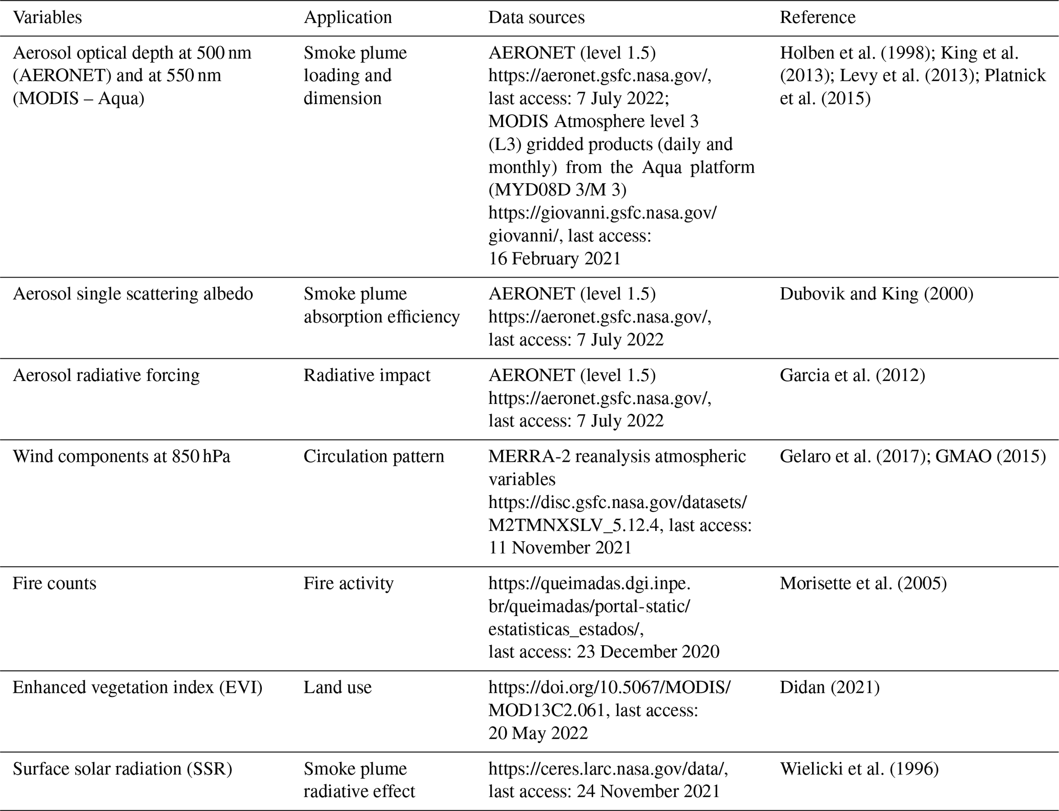
To better contextualize the 2020 biomass burning season, we also analyzed the interannual variability (2003 to 2020) of the fire counts in each of the considered biomes. Table 1 presents the variables used and their respective applications, data sources, and references. Fire counts were obtained from the Brazilian Space Agency (Instituto Nacional de Pesquisas Espaciais – INPE). These are important data to explore the spatial dynamics of smoke emission sources and, to some extent, to analyze the distribution of illegal biomass burning, which has been the main driver of the regional smoke plume in Brazilian biomes. The fire counts used are based on the Moderate Resolution Imaging Spectroradiometer (MODIS) data and two algorithms. In summary, according to Morisette et al. (2005), the algorithms use empirically derived thresholds based on digital numbers (DNs) at channels 20 (at around 3.7 µm) and 9 (around 440 nm). In the daytime algorithm, pixels are classified as “fire” if two conditions are satisfied, i.e., DNs higher than 3000 at channel 20 and lower than 3300 at channel 9. The nighttime algorithm requires only one condition, i.e., DNs higher than 3000 at channel 20.
To estimate the direct effect of the aerosol plume on the reduction in surface solar radiation (SSR), instantaneous retrievals of the CERES (Clouds and the Earth's Radiant Energy System) Single Scanner Footprint (SSF), level 3, during Aqua overpasses were used. This variable is estimated by a combination of CERES shortwave (SW) upward irradiance at the top of the atmosphere retrievals, ancillary meteorological data, surface, aerosol, gases, and cloud properties. These inputs are used in the Langley parameterized shortwave algorithm (LPSA; Kratz et al., 2020) to estimate the shortwave downward irradiance at the surface from 0.2 to 5.0 µm. The output is gridded in a 1∘ by 1∘ latitude/longitude resolution. Cloud-free scenes, when the cloud fraction is less than 0.1 % in a given footprint (NASA, 2018), in the presence of aerosols were selected to account only for the aerosol direct effect on radiation. The aerosol model used in the CERES surface irradiance calculations is very briefly described in Kratz et al. (2020). It uses near-real time daily AODs from the Model for Atmospheric Transport and Chemistry (MATCH; Collins et al., 2001; Rasch et al., 1997). The Optical Properties of Aerosols and Clouds (OPAC) Global Aerosol Data Set (GADS) was used to obtain the intrinsic aerosol properties, such as single scattering albedo and asymmetry parameter (Hess et al., 1998).
Wind circulation at 850 hPa plays a determinant role on the transport of smoke over South America (Freitas et al., 2005) and, therefore, on the regional smoke plume structure, especially for areas downwind of the main biomass burning areas, namely south of Amazon rainforest and the western portion of the Cerrado ecosystem. Due to its location, the Pantanal biome is subject to smoke transport from Amazon Rainforest and Cerrado. The wind dataset used to perform this analysis was taken from MERRA-2 (Modern-Era Retrospective analysis for Research and Applications, Version 2) reanalysis (Gelaro et al., 2017). The interannual variability in the fire counts and AOD were analyzed, based on monthly mean values (July, August, September, and October), and from the perspective of the selected biomes. Subsequently, the interannual variability in single scattering albedo and mean radiative forcing were analyzed. Those variables were also based on monthly mean values from AERONET stations located in different positions of the regional plume. September and October were selected to carry out a more comprehensive geographical analysis of the features and impact on SSR of the 2020 regional smoke plume. Targeting a comparison analysis, RSPs of the most-polluted years in the period analyzed were included in this analysis. The radiative impact of these plumes, based on the anomaly in downward SSR, was also compared.
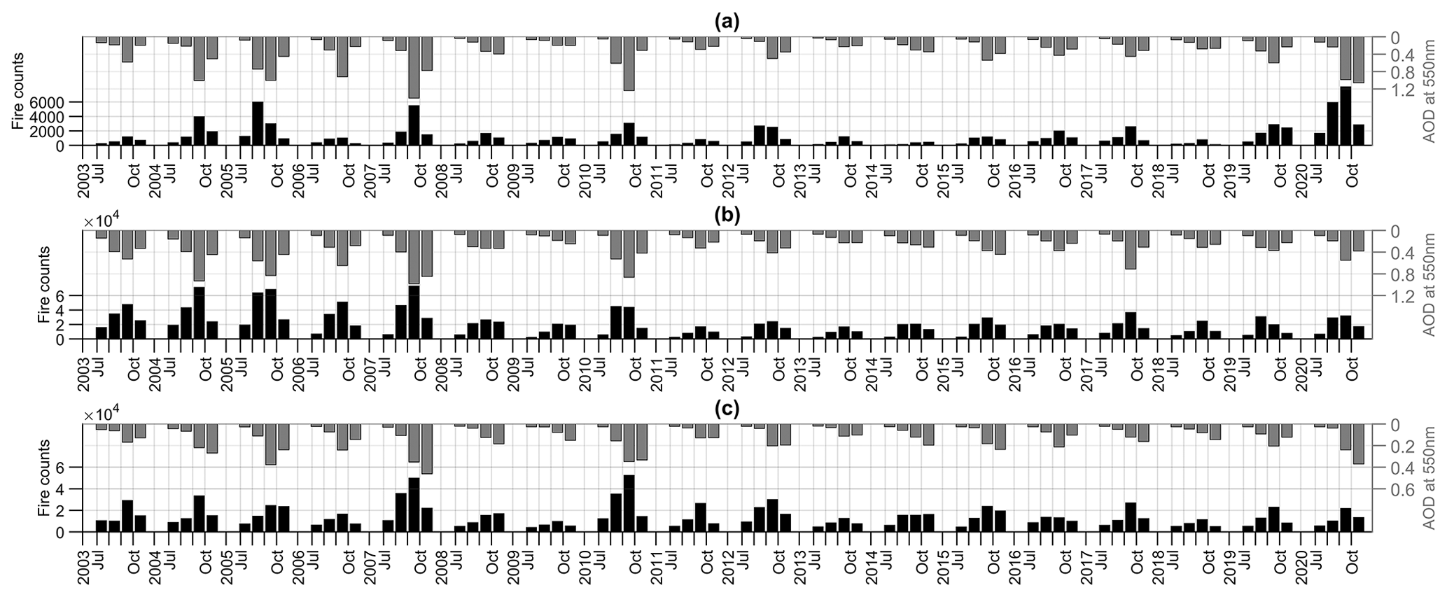
Figure 2Monthly (from July to October) interannual evolution of fire counts (black) and aerosol optical depth at 550 nm (gray) for the years from 2003 to 2020 for the (a) Pantanal, (b) Amazonia, and (c) Cerrado biomes.
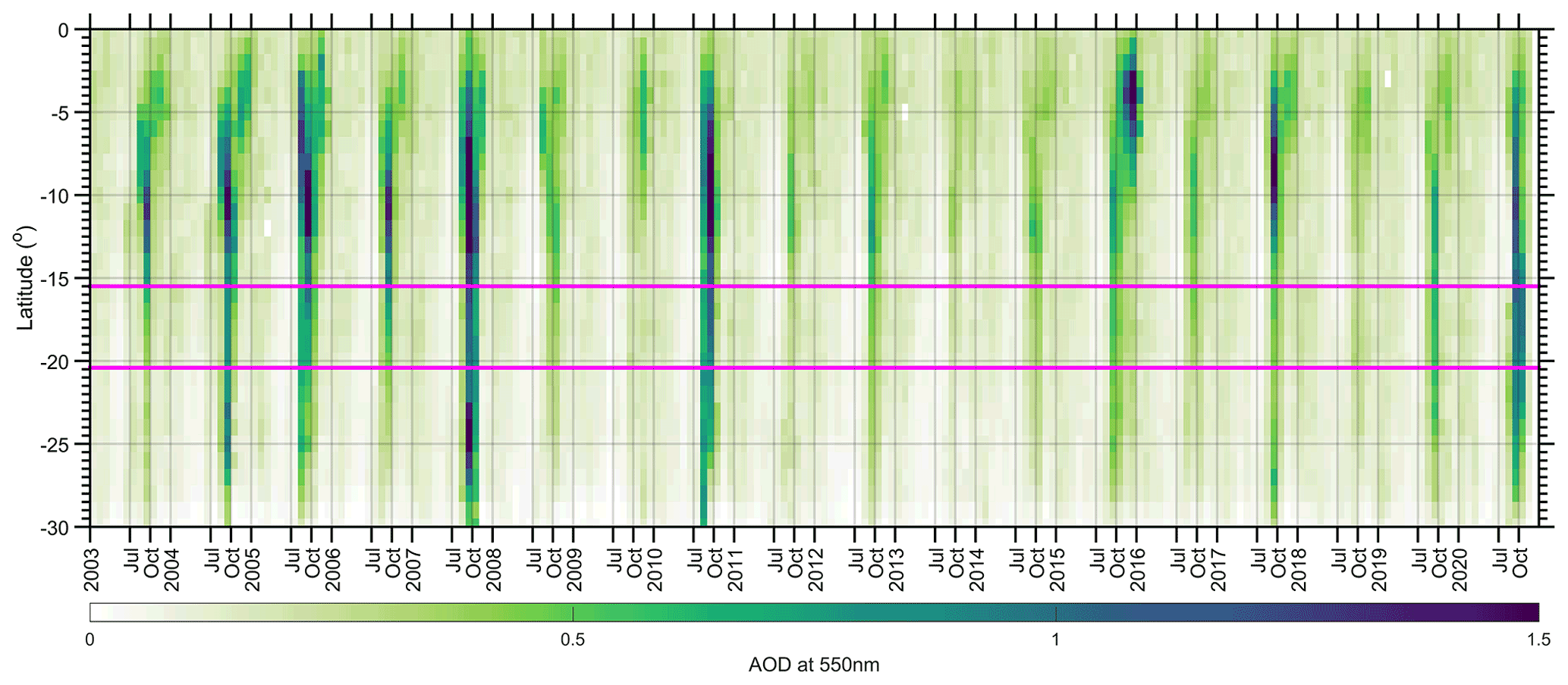
Figure 3Hovmöller diagram of mean AOD at 550 nm from the Amazon Rainforest latitudes to the Pantanal downwind regions, considering the average between the Pantanal borders at western (58.5∘ W) and eastern (54.96∘ W) longitudes (see Fig. 1). The magenta line represents the northern and southern limits of Pantanal. Each year's label is defined at its beginning, 1 January, also the case for the months of July and October, which is used to highlight the biomass burning season period.

Figure 4Multiyear analysis (2003–2020) of (a) monthly mean aerosol optical depth at 550 nm (AOD at 550 nm) as a function of the fire count for Pantanal biome. (b) Monthly mean aerosol optical depth at 550 nm (AOD at 550 nm) over Pantanal as a function of monthly mean AOD at 550 nm over Amazonia. The months of August, September, and October of the year 2020 are highlighted red.
3.1 Fire count and smoke aerosol loading over the Amazon, Cerrado, and Pantanal: intraseasonal and interannual variability
This section addresses the interannual and the intraseasonal variability in monthly fire counts and mean smoke aerosol loading for the three selected biomes (Amazon, Cerrado, and Pantanal) during the biomass burning season of the last 18 years, from 2003 to 2020. Figure 2 shows, for each biome and multiple years, the intraseasonal evolution (July, August, September, and October) of fire counts and smoke aerosol loading. The typical intraseasonality of the biomass burning season is observed for most of all of the 18 years as follows: from the transition month of July, the number of fire counts increased significantly in the following months, generally reaching its peak in September. After that, the number of fire counts decreased, but still remained high, in October, until the next wet season. The burned area variability, not shown here, closely follows the variability in fire counts. For the Amazonia biome, in terms of fire count and mean smoke aerosol loading, the 2020 biomass burning season closely followed the general features of the last 9 years (2011–2020). Regarding the peak of smoke aerosols over Amazonia, in the last 10 years, September 2017 overpowered all Septembers, including that of 2020. Looking further back in time, the Amazonia biomass burning seasons of the years 2004, 2005, 2007, and 2010 were the most fire active and polluted years, with the mean AOD at 550 nm over the biome reaching a value close to 1, which was, in some cases, almost twice that observed in 2020. A similar feature can be stated for the fire count. Regarding the intraseasonal behavior, for all highly polluted biomass burning seasons, September stood out as the most-polluted month in Amazonia. For the Cerrado ecosystem, while the fire count during the 2020 biomass burning season was not significantly different from the previous 9 years (2011–2020) of biomass burning seasons, the smoke aerosol loading was exceptionally high in October, but it has a precedent when one looks further in the past (e.g., 2007). Similar to Amazonia, during the mid-2000s, Cerrado presented its more fire active and polluted years (2004, 2005, and 2007) compared to the period here analyzed (and including 2010). However, when one looks at the Pantanal biome biomass burning seasons time series, the year 2020 was indeed an exceptional season in terms of fire count, with almost 3 and 4 times the fire counts typically observed in August and September of the last few decades, respectively. Those figures surpass the fire counts of the years of 2005 and 2007, which are two of the most fire active biomass burning seasons in the last 2 decades in Pantanal. The 2020 high fire counts scenario for Pantanal is also seen in the aerosol mean loading over the biome during September, with twice the values observed in recent years (2011–2020), but again not unprecedented in the history of Pantanal. For the years of 2004, 2005, 2007, and 2010, the Pantanal smoke aerosol loading was as high as, or even higher than, that observed in the 2020 peak. In 2007, during September, the highest aerosol loading was observed within the period analyzed. Unlike 2020, in the polluted years of the 2000s and the year 2010, large smoke loading was also observed upwind of Pantanal in the southern Amazon Rainforest and the western part of Cerrado, as can be seen in the Hovmöller diagram of AOD at 550 nm (Fig. 3). This indicates the relevant contribution of smoke advection from these biomes to the high aerosol loading observed over Pantanal, especially during 2010, when local fire counts were relatively low. From 2011 to 2019, both fire counts and smoke levels in Pantanal were well below the observed values during the previous polluted years, even when high levels of smoke were observed in the upwind regions, for instance in 2017 (Fig. 3). In that year, the core of the transport toward the south was over Paraguay. Regarding the high levels of smoke in the northern part of the Amazon basin at the end of the year 2015 (Fig. 3), which did not have a significant influence on the Pantanal region, it is worth mentioning that it occurred during an El Niño event, which is when this part of the Amazon typically experiences drought scenarios and a higher incidence of fire counts. Indeed, according to Marengo et al. (2017), the Amazon onset of the rainy season in 2015 occurred later than normal, and the region was characterized by drought in 2016. As in 2015 (Marengo et al., 2017) and 2020 (Marengo et al., 2021), drought conditions were also present, either across the central or north region of Brazil, during the polluted years of 2005, 2007, and 2010 (Jimenez et al., 2018; Libonati et al., 2021), corroborating the critical role of climate variability combined with human factors to the exacerbation of the biomass burning severity in Brazil. Regarding the years characterized by less-polluted scenarios in Pantanal (2011–2019), they were consistently associated with relatively low local fire counts. This scenario changed during the 2020 biomass burning season, when the total fire counts at the peak of the biomass burning season in Pantanal surpassed all the previous analyzed years (Fig. 2). According to Marengo et al. (2021), since the beginning of the fire activity monitoring in Brazil in 1998, the largest number of fires over Pantanal was detected in 2005, and in 2020, it was 76 % higher. As mentioned, the level of aerosol loading over the biome at the peak of the 2020 burning season was similar to the early polluted years (Fig. 2) in the middle of 2000s. However, opposite to the former years, smoke loading in Pantanal in 2020 peaked in October when the smoke loading upwind of Pantanal, mainly in the Amazon biome, was atypically much lower than that over Pantanal (Fig. 3). This suggests that Pantanal itself was the main source of smoke in its domain, with advection from outer regions playing a secondary role. October also followed a highly polluted September, when there was an explosion in fire counts across Pantanal. The increase in smoke over Pantanal in mid-September occurred simultaneously with the peak of smoke in Amazonia, suggesting that, at this time, the smoke plume over Pantanal had also received a contribution from biomass burning emission from Amazonia (Fig. 3). While the aerosol loading observed during the 2020 biomass burning over Pantanal was not unique from historical perspective, there are relevant differences between 2020 and previous polluted years. Regarding the intraseasonal variability in smoke aerosol loading, October 2020 in Pantanal can be evaluated as being exceptional when compared with October from the previous years of the time series. An interesting aspect worth emphasizing for October 2020 is that Pantanal presented much lower fire counts compared to August and September (Fig. 3). However, August's higher fire count in Pantanal did not translate into a high level of smoke over the wetland biome. Further analysis was done to clarify these aspects, focusing on the correlation between smoke loading over Pantanal and the local fire count (Fig. 4a) and on the correlation between smoke over Pantanal and over Amazonia (Fig. 4b). The scatterplot of smoke loading over Amazonia versus smoke over Pantanal shows that the smoke loading over Pantanal has a stronger relationship with smoke over Amazon than with fire counts within the biome. This suggests that, in general, smoke over Pantanal is more affected by advection than by local fires. However, the year 2020 stands out as an outlier. Typically, mean AOD at 550 nm over the Pantanal domain is similar to, or a fraction of, that over the Amazonia domain. That was not the case for September and October of 2020, when mean AOD at 550 nm over Pantanal was much higher than over Amazonia, which is an indication that locally produced smoke played a major role on the amount of smoke over the Pantanal atmosphere column.

Figure 5(a) Fire count distribution over Pantanal for August, September, and October of 2020 using the enhanced vegetation index (EVI) as the background. (b) Monthly (August, September, and October) distribution of fire count over Pantanal and over conservation and indigenous areas located within the biome.
To analyze why, in August 2020, the higher fire count did not translate to a higher smoke amount. compared with September and October 2020, the monthly distribution of the fire count across Pantanal (Fig. 5a) was analyzed as a function of the land used (conservation units and indigenous areas) and enhanced vegetation index (EVI). The analysis (Fig. 5) shows that, despite the large fire count occurrence, August presented a reduced number of fires within conservation areas (where higher biomass density is present). However, during September and October, there was a significant increase in the fire number within those areas, which could explain the larger aerosol emissions and, consequently, higher AOD values over Pantanal compared to August.
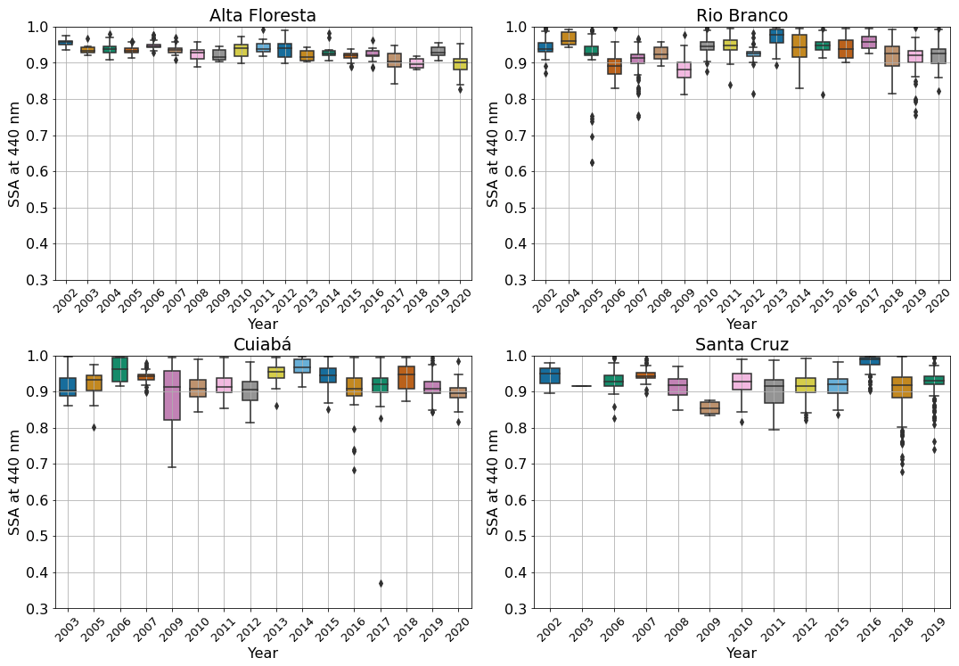
Figure 6Multiyear box plots of the monthly single scattering albedo at 440 nm (SSA at 440 nm) from 2003 to 2020 for four AERONET sites, namely Alta Floresta, Cuiabá, Rio Branco, and Santa Cruz. In each box, the black line in the center represents the median, and the lower and upper limits are the first and the third quartiles, respectively. The vertical lines extending from the box represent the spread of instantaneous SSA at 440 nm, with the length being 1.5 times the interquartile range.
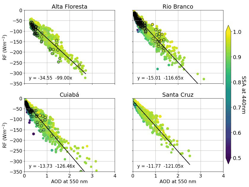
Figure 7Aerosol direct instantaneous radiative forcing as function of AOD at 550 nm at AERONET sites highlighting 2020 values (black) against historical values (2003–2019).
A possible shift in the mean composition of the regional smoke aerosol plume optical properties (mainly light absorption efficiency) during the 2020 biomass burning season was also explored via retrievals of single scattering albedo (SSA) from AERONET stations. Since there are no AERONET stations operating in Pantanal, the analysis of SSA was carried out from stations in the neighborhood of Pantanal (Cuiabá) and somewhere else across Amazonia and in Santa Cruz, in Bolivia. The results obtained did not show a significant change between the mean SSA for the 2020 biomass burning season and that from previous years (Fig. 6). Referring to Cuiabá, the closest AERONET site to Pantanal, the mean SSA in 2020 was within the site's typical variability that also was the case for the Rio Branco, Alta Floresta, and Santa Cruz sites. Multiyear instantaneous aerosol radiative forcing versus AOD at 550 nm from these AERONET stations, and as a function of SSA, were also analyzed (Fig. 7) by comparing 2020 with the previous years (2003 to 2019). It is possible to observe that not only AOD but also SSA affects the downward solar irradiance at the surface. However, no exceptional difference can be noticed in the 2020 data when compared with the entire dataset. It is worth mentioning that the AERONET data from quality level 2.0 for 2020 is not yet available, so level 1.5 was used. Therefore, future and further analysis on this matter is highly recommended in order to evaluate the posed hypotheses, although, as observed in Fig. S1, there is very good agreement between the SSA retrievals for levels 1.5 and 2.0.

Figure 8Spatial distribution of the mean aerosol optical depth at 550 nm (AOD at 550 nm) and wind pattern at 850 hPa for September (a) and October (b) of different years. The area limited by the black solid line represents the regions with AOD550 nm higher than 0.5, and its dimension (area) and mean AOD550 nm are also presented. The biome borders are represented by the colors blue (Amazon Rainforest), red (Cerrado ecosystem), and green (Pantanal).
3.2 Regional smoke plume and surface solar radiation anomaly: spatial and interannual analysis
Climatologically, September is the peak of the biomass burning season over a large area of South America and of Brazil in particular. Therefore, September was selected to explore the spatial distribution, loading, and impact on the downward solar radiation at the surface of the regional smoke plume for 2020, and the most-polluted years in the time series analyzed, namely 2004, 2005, 2007, 2010, and 2017. Considering the particularity of smoke over Pantanal in October 2020, that month was also added to this analysis of the RSP feature and impact on SSR. Figure 8 presents the interannual variability in the geographical distribution of the RSP for September and October for the most-polluted years. Although it was one of the most-polluted in the last 5 recent years, the 2020 regional plume could not be considered to be an exceptional plume when compared, for instance, with the historical RSP of the years 2007, 2010, and 2005. Among the years analyzed, the year 2007 stands out as being the top polluted, for both September and October. However, during October 2020, it is possible to visualize that the peak of the smoke over the continent was centered in Pantanal (Fig. 8b), corroborating the previous discussion that 2020 biomass burning exceptionality was restricted to the Pantanal biome. The area of the RSP core, considered to be the extension of the smoke plume delimited by the isoline of AOD at 550 nm of 0.5 (area) and its respective mean intensity (AOD at 550 nm level), is also identified. The 2007 RSP presented the largest (5 740 811 km2) and most-polluted domain (mean AOD at 550 nm > 1.0), a characteristic that also extended to the month of October. The area and AOD at 550 nm figures during September for the 2020 RSP were, respectively, 2 450 641 km2 and 0.68.
Due to the wind circulation pattern in the region, in general, the smoke from fires in the Amazon Rainforest and Cerrado ecosystem are transported westward, crossing other South American countries until it reaches the Andes mountain range barrier (Freitas et al., 2005), where the wind circulation becomes predominantly meridional and southwards, with a variable zonal component that can fluctuate the transport of smoke between the southeastern and the southern portions of Brazil. Going southwards, the plume can reach the Pantanal region, among other locations, but the smoke usually becomes diluted during this transport process. Related to the flow of the regional smoke plume towards the population centers of the southeastern coast, a stronger feature of the 2020 regional smoke plume, an analysis of previous years evidenced that this has also been seen in the past. For example, in 2004 and 2005, the monthly flow patterns were also towards the highly populated centers in the southeast of Brazil.

Figure 9Spatial distribution of the mean surface solar irradiance under cloudless conditions and in the presence of aerosol for the months of September and October of different years. The biome borders are represented by the colors blue (Amazon Rainforest), red (Cerrado ecosystem), and magenta (Pantanal).
Figure 9 also shows that the anomaly of solar radiation in cloud-free conditions occurred over the regions more severely affected by the aerosol plume, consistent with the spatial distribution of AOD, as expected. Again, in 2020, the solar energy reduction was surpassed by previous top-polluted years, especially 2007, when the SSR anomaly over a large portion of the continent, including the western portion of Pantanal, reached values up to −300 W m−2. It is also possible to see that, in 2005, as in 2020, the southeastern portion of Brazil experienced a larger SSR reduction as a result of the persistent transport of smoke toward that region. As suggested by the AOD field, the available solar energy reaching the ground in October 2020 over Pantanal was significantly reduced (up to 200 W m−2).
The 2020 biomass burning season in Brazil attracted unprecedented attention from national and international media and society in general. The Pantanal biome was a hot spot in this entire discussion. The wetland biome's role in the regional smoke plume (RSP) has been marginal throughout the years. However, with the explosion of fire counts across Pantanal in 2020, there was a question about the role of Pantanal's smoke emissions to the RSP during the 2020 biomass burning season. In this study, we analyzed to what extent the RSP produced during the 2020 biomass burning season and its impact on solar surface radiation under cloudless scenarios differs from previous years, from 2003 to 2019, and, in particular, the highly polluted former RSPs. Additionally, we analyzed the interannual and intraseasonal variability in the fire counts and aerosol loading, with emphasis on the biomes of the Amazon Rainforest, Cerrado, and Pantanal. In the last 18 years, from the point of view of the Amazon Rainforest and Cerrado ecosystem, the year 2020 can be considered to be an ordinary biomass burning season, far exceeding the most fire active and polluted years of 2010 and 2007. For these years, 2010 and 2007, Amazonia and the western portion of Cerrado experienced their largest fire counts and aerosol loading within the analyzed period. However, for Pantanal, under certain aspects, 2020 was a very particular year. This is not exactly due to the smoke loading over the biome, since the biome experienced a higher smoke loading in September 2007, but due to the relative contribution of the local fire when compared to advection from upwind areas and the amount of smoke observed in October. The analysis revealed that, typically, Pantanal smoke loading has a stronger relationship with smoke over the Amazon than with fire counts within the biome, suggesting that AOD over Pantanal is more affected by advection than by local fires. However, in 2020, that was not the case because local fire dominated. Usually, smoke loading over Pantanal is a fraction of that over the Amazonia domain, but for September and October of 2020, the mean smoke loading over Pantanal was much higher than over Amazonia – an indication that smoke produced locally played an atypical role in the smoke level over Pantanal. In the 2020 biomass burning season, fire counts in Pantanal were 3.4 times higher than the mean value from 2003 to 2020. As important as the amount of fire is the nature of the areas burned within Pantanal being revealed to determine the amount of smoke produced during September and October. From September on, there was a significant increase in fire counts within conservation and indigenous areas, where higher biomass density is present, which would explain the large smoke plumes over Pantanal – even during October when the number of fires were significantly reduced. The entire biome was continuously covered by a thick layer of smoke from west to east and from south to north for almost 1.5 months, which resulted in a monthly (October) mean deficit of solar radiation at the surface up to 200 W m−2. The impact of this reduction in incoming solar radiation on biological and surface–atmosphere interaction processes is yet to be evaluated. Additionally, considering the plume transport towards the highly productive central and southeast regions of Brazil, the country's capacity of production of renewable energy based on solar radiation is also affected. In a period when cloud cover is less frequent, and the generation of hydroelectric power, the main energy source in Brazil, decreases due to the lack of precipitation, a need for comprehensive governance is revealed.
In conclusion, from the RSP loading and area perspective, and when compared with previous years (2003–2019), the 2020 biomass burning season could not be identified as an exceptional year. However, when focusing on the Pantanal domain, there are three aspects that differ from typical features, i.e., the fire count observed in September, the smoke loading over the Pantanal biome during October, and the relative contribution of local fire to the local smoke loading when compared to the advection of smoke from the Amazonia domain. Pantanal biomass burning has received less attention throughout the years, when compared with Amazonia and Cerrado biomes. However, Pantanal is a critical piece in the regional hydrological cycle, with a strong connection with the two larger biomes. The role of the Pantanal surface–atmosphere interaction processes in support of local and regional biodiversity is indisputable. Although it is too early to infer a possible pattern change in the Pantanal biomass burning features, studies focusing on the 2020 atypical biomass burning season may shed light on potential scenarios that the region may experience in the future. Because of the likelihood of an increase in drought frequency and intensity, policymakers will need to take measures to mitigate future scenarios similar to the one shown here in 2020. Current knowledge on the Pantanal biome fire emission dynamics and smoke plume radiative properties and impacts is far limited compared to the Amazon Rainforest and Cerrado ecosystem.
Although the 2020 regional biomass burning season was not among the most polluted in the history of biomass burning in Brazil, the Pantanal 2020 biomass burning season represents the worst combination of a climate extreme applied to a fire-prone environment, coupled with inadequately enforced environmental regulations (Marengo et al., 2021; Libonati et al., 2020; Vale et al., 2021). According to Marengo et al. (2021), the years of 2019 and 2020 were characterized by the worst drought in 50 years in Pantanal. Vale et al. (2021) pointed out a large reduction in environmental fines during the pandemic. This was caused by a decrease in fine enforcement, not due to a decrease in environmental violations, as an increase in Amazonian deforestation was observed. The slashing of funding for environmental protection and climate actions during the pandemic years has compounded the environmental harm imposed by legislative acts aimed at degrading environmental protection. There are still open questions about the specific behavior of human intervention in Pantanal in 2020; however, a lack of studies on the human causes and responses to fires in the Pantanal has been recognized as a challenge to a full comprehension of what happened (Libonati et al., 2020). One also has to point out that there is a need to advance scientific knowledge on the Pantanal climate process in the context of both local environmental degradation and global climate change scenarios. This evaluation has, as its basis, the notable lack of regular monitoring and comprehensive experimental campaigns focusing on the biome and its complex interdependence relationship with the neighborhood biomes, Amazonia, and Cerrado and downwind regions.
All the datasets (AERONET, MODIS, CERES, MERRA-2, and INPE fire counts) used in this study are publicly available and can be downloaded from their respective websites (see Table 1). All analysis codes were specifically developed for this study and are available from the contact author upon request.
The supplement related to this article is available online at: https://doi.org/10.5194/acp-22-15021-2022-supplement.
NEdR, ETS, and MAY designed and performed the research, analyzed the data, and wrote the paper.
The contact author has declared that none of the authors has any competing interests.
Publisher's note: Copernicus Publications remains neutral with regard to jurisdictional claims in published maps and institutional affiliations.
We acknowledge the AERONET, MERRA-2, Programa Queimadas-INPE, CERES, and MODIS mission scientists, principal investigators, and associated NASA personnel, for the production of the data used in this research effort. We would also like to thank the reviewers of this paper, Lorraine Remer and an anonymous reviewer, for their thoughtful comments and efforts towards improving this work.
This research has been supported by the Fundação de Amparo à Pesquisa do Estado de São Paulo (grant nos. 2018/16048-6 and 2016/18438-0) and the Conselho Nacional de Desenvolvimento Científico e Tecnológico (grant nos. 313005/2018-4, 311984/2021-5, and 421870/2018-4).
This paper was edited by Joshua Fu and reviewed by Lorraine Remer and one anonymous referee.
Alho, C.: Biodiversity of the Pantanal: response to seasonal flooding regime and to environmental degradation, Braz. J. Biol., 68, 957–966, https://doi.org/10.1590/S1519-69842008000500005, 2008.
Alho, C., Mamede, S., Benites, M., Andrade, B., and Sepulveda, J.: Threats to the biodiversity of the brazilian Pantanal due to land use and occupation, Ambiente Sociedade, 22, 1–22, https://doi.org/10.1590/1809-4422asoc201701891vu2019L3AO, 2019.
Artaxo, P., Fernandas, E. T., Martins, J. V., Yamasoe, M. A., Hobbs, P. V., Maenhaut, W., Longo, K. M., and Castanho, A.: Large-scale aerosol source apportionment in Amazonia, J. Geophys. Res.-Atmos., 103, 31837–31847, https://doi.org/10.1029/98JD02346, 1998.
Artaxo, P., Rizzo, L. V., Brito, J. F., Barbosa, H. M. J., Arana, A., Sena, E. T., Cirino, G. G., Bastos, W., Martin, S. T., and Andreae, M. O.: Atmospheric aerosols in Amazonia and land use change: from natural biogenic to biomass burning conditions, Faraday Discuss., 165, 203–235, https://doi.org/10.1039/C3FD00052D, 2013.
Chen, Y., Morton, D. C., Jin, Y., Collatz, G. J., Kasibhatla, P. S., van der Werf, G. R., DeFries, R. S., and Randerson, J. T.: Long-term trends and interannual variability of forest, savanna and agricultural fires in South America, Carbon Manag., 4, 617–638, https://doi.org/10.4155/cmt.13.61, 2013.
Collins, W. D., Rasch, P. J., Eaton, B. E., Khattatov, B. V., Lamarque, J.-F., and Zender, C. S.: Simulating aerosols using a chemical transport model with assimilation of satellite aerosol retrievals: Methodology for INDOEX, J. Geophys. Res.-Atmos., 106, 7313–7336, https://doi.org/10.1029/2000JD900507, 2001.
Didan, K.: MOD13C2 MODIS/Terra Vegetation Indices Monthly L3 Global 0.05Deg CMG V061, NASA EOSDIS Land Processes DAAC [data set], https://doi.org/10.5067/MODIS/MOD13C2.061, 2021.
Dubovik, O. and King, M. D.: A flexible inversion algorithm for retrieval of aerosol optical properties from Sun and sky radiance mea335 surements, J. Geophys. Res.-Atmos., 105, 20673–20696, https://doi.org/10.1029/2000JD900282,2000.
Freitas, S., Longo, K., and Dias, M. S.: Monitoring the transport of biomass burning emissions in South America, Environ. Fluid Mech., 5, 135–167, https://doi.org/10.1007/s10652-005-0243-7, 2005.
FSP: Incontrolável, fogo já consumiu 26,5 % do Pantanal, mostram satélites, FSP [sample], https://www1.folha.uol.com.br/ambiente/2020/10/incontrolavel-fogo-ja-consumiu-265-do-pantanal-mostram-satelites.shtml (last access: 3 April 2021), 2020.
FSP: About 40 % of Th Pantanal of Mato Grosso Was Burn in 2020, FSP [sample], https://www1.folha.uol.com.br/internacional/en/scienceandhealth/2021/01/about-40-of-the-pantanal-of-mato-grosso-was-burnt-in-2020.shtml, last access: 6 April 2021.
García, O. E., Díaz, J. P., Expósito, F. J., Díaz, A. M., Dubovik, O., Derimian, Y., Dubuisson, P., and Roger, J.-C.: Shortwave radiative forcing and efficiency of key aerosol types using AERONET data, Atmos. Chem. Phys., 12, 5129–5145, https://doi.org/10.5194/acp-12-5129-2012, 2012.
Gelaro, R., McCarty, W., Suárez, M. J., Todling, R., Molod, A., Takacs, L., Randles, C. A., Darmenov, A., Bosilovich, M. G., Reichle, R., Wargan, K., Coy, L., Cullather, R., Draper, C., Akella, S., Buchard, V., Conaty, A., da Silva, A. M., Gu, W., Kim, G.-K., Koster, R., Lucchesi, R., Merkova, D., Nielsen, J. E., Partyka, G., Pawson, S., Putman, W., Rienecker, M., Schubert, S. D., Sienkiewicz, M., and Zhao, B.: The Modern-Era Retrospective Analysis for Research and Applications, Version 2 (MERRA-2), J. Climate, 30, 5419–5454, https://doi.org/10.1175/JCLI-D-16-0758.1, 2017.
GMAO: MERRA-2 tavgM_2d_slv_Nx: 2d, Monthly mean, Time-Averaged, Single-Level, Assimilation, Single-Level Diagnostics V5.12.4, Goddard Earth Sciences Data and Information Services Center (GES DISC) [data set], Greenbelt, MD, USA, https://doi.org/10.5067/AP1B0BA5PD2K, 2015.
Hess, M., Koepke, P., and Schult, I.: Optical Properties of Aerosols and Clouds: The Software Package OPAC, B. Am. Meteorol. Soc., 79, 831–844, https://doi.org/10.1175/1520-0477(1998)079<0831:OPOAAC>2.0.CO;2, 1998.
Holben, B., Eck, T., Slutsker, I., Tanré, D., Buis, J., Setzer, A., Vermote, E., Reagan, J., Kaufman, Y., Nakajima, T., Lavenu, F., Jankowiak, I., and Smirnov, A.: AERONET—A Federated Instrument Network and Data Archive for Aerosol Characterization, Remote Sens. Environ., 66, 1–16, https://doi.org/10.1016/S0034-4257(98)00031-5, 1998.
Ignotti, E., Valente, J. G., Longo, K. M., Freitas, S. R., de Souza Hacon, S., and Netto, P. A.: Impact on human health of particulate matter emitted from burnings in the Brazilian Amazon region, Rev. Saude Publ., 44, 121–130, https://doi.org/10.1590/S0034-89102010000100013, 2010.
Jimenez, J. C., Libonati, R., and Peres, L. F.: Droughts Over Amazonia in 2005, 2010, and 2015: A Cloud Cover Perspective, Front. Earth Sci., 6, 227, https://doi.org/10.3389/feart.2018.00227, 2018.
King, M. D., Platnick, S., Menzel, W. P., Ackerman, S. A., and Hubanks, P. A.: Spatial and Temporal Distribution of Clouds Observed by MODIS Onboard the Terra and Aqua Satellites, IEEE T. Geosci. Remote, 51, 3826–3852, https://doi.org/10.1109/TGRS.2012.2227333, 2013.
Kratz, D. P., Gupta, S. K., Wilber, A. C., and Sothcott, V. E.: Validation of the CERES Edition-4A Surface-Only Flux Algorithms, J. Appl. Meteorol. Clim., 59, 281–295, https://doi.org/10.1175/JAMC-D-19-0068.1, 2020.
Le Monde: Le Pantanal, au Brésil, paradis de biodiversité ravagé par les flammes, Le Monde [sample], https://www.lemonde.fr/planete/article/2020/09/29/le-pantanal-paradis-de-biodiversite-ravage-par-les-flammes_6054087_3244.html (last access: 3 April 2021), 2020.
Levy, R. C., Mattoo, S., Munchak, L. A., Remer, L. A., Sayer, A. M., Patadia, F., and Hsu, N. C.: The Collection 6 MODIS aerosol products over land and ocean, Atmos. Meas. Tech., 6, 2989–3034, https://doi.org/10.5194/amt-6-2989-2013, 2013.
Libonati, R., DaCamara, C. C., Peres, L. F., Sander de Carvalho, L. A., and Garcia, L. C.: Rescue Brazil's burning Pantanal wetlands, Nature, 588, 217–219, https://doi.org/10.1038/d41586-020-03464-1, 2020.
Libonati, R., Pereira, J. M. C., Da Camara, C. C., Peres, L. F., Oom, D., Rodrigues, J. A., Santos, F. L. M., Trigo, R. M., Gouveia, C. M. P., Machado-Silva, F., Enrich-Prast, A., and Silva, J. M. N.: Twenty-first century droughts have not increasingly exacerbated fire season severity in the Brazilian Amazon, Sci. Rep.-UK, 11, 1–13, https://doi.org/10.1038/s41598-021-82158-8, 2021.
Longo, K. M., Freitas, S. R., Andreae, M. O., Yokelson, R., and Artaxo, P.: Biomass Burning in Amazonia: Emissions, Long-Range Transport of Smoke and Its Regional and Remote Impacts, in: Amazonia and Global Change, Volume 186, Geophysical Monograph Series, American Geophysical Union (AGU), https://doi.org/10.1029/2008GM000717, 207–232, 2009.
Marengo, J. A., Fisch, G. F., Alves, L. M., Sousa, N. V., Fu, R., and Zhuang, Y.: Meteorological context of the onset and end of the rainy season in Central Amazonia during the GoAmazon2014/5, Atmos. Chem. Phys., 17, 7671–7681, https://doi.org/10.5194/acp-17-7671-2017, 2017.
Marengo, J. A., Cunha, A. P., Cuartas, L. A., Deusdará Leal, K. R., Broedel, E., Seluchi, M. E., Michelin, C. M., De Praga Baião, C. F., Chuchón Angulo, E., Almeida, E. K., and Kazmierczak, M. L.: Extreme Drought in the Brazilian Pantanal in 2019–2020: Characterization, Causes, and Impacts, Frontiers in Water, 3, 13, https://doi.org/10.3389/frwa.2021.639204, 2021.
Moreira, D. S., Longo, K. M., Freitas, S. R., Yamasoe, M. A., Mercado, L. M., Rosário, N. E., Gloor, E., Viana, R. S. M., Miller, J. B., Gatti, L. V., Wiedemann, K. T., Domingues, L. K. G., and Correia, C. C. S.: Modeling the radiative effects of biomass burning aerosols on carbon fluxes in the Amazon region, Atmos. Chem. Phys., 17, 14785–14810, https://doi.org/10.5194/acp-17-14785-2017, 2017.
Morisette, J. T., Giglio, L., Csiszar, I., Setzer, A., Schroeder, W., Morton, D., and Justice, C. O.: Validation of MODIS Active Fire Detection Products Derived from Two Algorithms, Earth Interact., 9, 1–25, https://doi.org/10.1175/EI141.1, 2005.
NASA: CERES Time-Interpolated TOA Fluxes, Clouds and Aerosols, NASA [data set] https://ceres.larc.nasa.gov/documents/DPC/DPC_current/pdfs/DPC_SSF1deg-Day_R5V1.pdf (last access: 30 September 2021), 2018.
NYT: The World's Largest Tropical Wetland Has Become an Inferno, NYT [sample], https://www.nytimes.com/interactive/2020/10/13/climate/pantanal-brazil-fires.html (last access: 3 April 2021), 2020.
Pereira, G., Siqueira, R., Rosário, N. E., Longo, K. L., Freitas, S. R., Cardozo, F. S., Kaiser, J. W., and Wooster, M. J.: Assessment of fire emission inventories during the South American Biomass Burning Analysis (SAMBBA) experiment, Atmos. Chem. Phys., 16, 6961–6975, https://doi.org/10.5194/acp-16-6961-2016, 2016.
Pivello, V. R.: The Use of Fire in the Cerrado and Amazonian Rainforests of Brazil: Past and Present, Fire Ecol., 7, 24–39, https://doi.org/10.4996/fireecology.0701024, 2011.
Platnick, S., King, M., and Wind, G.: MODIS Atmosphere L2 Cloud Product (06_L2), NASA MODIS Adaptive Processing System, Goddard Space Flight Center [data set], USA, https://doi.org/10.5067/MODIS/MOD06_L2.006, 2015.
Pletsch, M. A. J. S., Junior, C. S., Penha, T., Silva, T. S. K. M. E., Pereira, G., Anderson, L. O., and Aragão, L. E.: The 2020 Brazilian Pantanal fires, An. Acad. Bras. Cienc., 93, 14785–14810, https://doi.org/10.1590/0001-3765202120210077, 2021.
Prins, E. M. and Menzel, W. P.: Geostationary satellite detection of bio mass burning in South America, Int. J. Remote Sens., 13, 2783–2799, https://doi.org/10.1080/01431169208904081, 1992.
Procopio, A. S., Artaxo, P., Kaufman, Y. J., Remer, L. A., Schafer, J. S., and Holben, B. N.: Multiyear analysis of amazonian biomass burning smoke radiative forcing of climate, Geophys. Res. Lett., 31, L03108, https://doi.org/10.1029/2003gl018646, 2004.
Rasch, P. J., Mahowald, N. M., and Eaton, B. E.: Representations of transport, convection, and the hydrologic cycle in chemical transport models: Implications for the modeling of short-lived and soluble species, J. Geophys. Res.-Atmos., 102, 28 127–138, https://doi.org/10.1029/97JD02087, 1997.
Reddington, C. L., Butt, E. W., Ridley, D. A., Artaxo, P., Morgan, W. T., Coe, H., and Spracklen, D. V.: Air quality and human health improvements from reductions in deforestation-related fire in Brazil, Nat. Geosci., 8, 768–771, https://doi.org/10.1038/ngeo2535,2015.
Rosário, N. E., Longo, K. M., Freitas, S. R., Yamasoe, M. A., and Fonseca, R. M.: Modeling the South American regional smoke plume: aerosol optical depth variability and surface shortwave flux perturbation, Atmos. Chem. Phys., 13, 2923–2938, https://doi.org/10.5194/acp-13-2923-2013, 2013.
Schafer, J. S., Eck, T. F., Holben, B. N., Artaxo, P., Yamasoe, M. A., and Procopio, A. S.: Observed reductions of total solar irradiance by biomass-burning aerosols in the Brazilian Amazon and Zambian Savanna, Geophys. Res. Lett., 29, 4, 1–4, https://doi.org/10.1029/2001GL014309, 2002.
Sena, E. T. and Artaxo, P.: A novel methodology for large-scale daily assessment of the direct radiative forcing of smoke aerosols, Atmos. Chem. Phys., 15, 5471–5483, https://doi.org/10.5194/acp-15-5471-2015, 2015.
Sena, E. T., Artaxo, P., and Correia, A. L.: Spatial variability of the direct radiative forcing of biomass burning aerosols and the effects of land use change in Amazonia, Atmos. Chem. Phys., 13, 1261–1275, https://doi.org/10.5194/acp-13-1261-2013, 2013.
Thornhill, G. D., Ryder, C. L., Highwood, E. J., Shaffrey, L. C., and Johnson, B. T.: The effect of South American biomass burning aerosol emissions on the regional climate, Atmos. Chem. Phys., 18, 5321–5342, https://doi.org/10.5194/acp-18-5321-2018, 2018.
Vale, M. M., Berenguer, E., Argollo de Menezes, M., Viveiros de Castro, E. B., Pugliese de Siqueira, L., and de Cássia Q. Portela, R.:The COVID-19 pandemic as an opportunity to weaken environmental protection in Brazil, Biol. Conserv., 255, 108–994, https://doi.org/10.1016/j.biocon.2021.108994, 2021.
Yamasoe, M. A., von Randow, C., Manzi, A. O., Schafer, J. S., Eck, T. F., and Holben, B. N.: Effect of smoke and clouds on the transmissivity of photosynthetically active radiation inside the canopy, Atmos. Chem. Phys., 6, 1645–1656, https://doi.org/10.5194/acp-6-1645-2006, 2006.
WWF: Fires in the Pantanal grow more than 200 % and break a record, WWF [sample], https://www.wwf.org.br/informacoes/english/?76914/Fires-in-the-Pantanal-grow-more-than-200-and-break-a-record (last access: 3 April 2021), 2020.