
Articles | Volume 26, issue 19
https://doi.org/10.5194/acp-26-14205-2026
© Author(s) 2026. This work is distributed under
the Creative Commons Attribution 4.0 License.
the Creative Commons Attribution 4.0 License.
https://doi.org/10.5194/acp-26-14205-2026
© Author(s) 2026. This work is distributed under
the Creative Commons Attribution 4.0 License.
the Creative Commons Attribution 4.0 License.
Research article
| 
09 Oct 2026
Research article |
| 09 Oct 2026
Physics-constrained transfer learning with a spectral-fidelity-preserving model for satellite remote sensing applications
School of Atmospheric Sciences and Guangdong Province Key Laboratory for Climate Change and Natural Disaster Studies, Sun Yat-sen University and Southern Laboratory of Ocean Science and Engineering, Zhuhai 519082, China
School of Atmospheric Sciences and Guangdong Province Key Laboratory for Climate Change and Natural Disaster Studies, Sun Yat-sen University and Southern Laboratory of Ocean Science and Engineering, Zhuhai 519082, China

National Satellite Meteorological Center (National Centre for Space Weather), Innovation Center for FengYun Meteorological Satellite (FYSIC), and Key Laboratory of Radiometric Calibration and Validation for Environmental Satellites, China Meteorological Administration (CMA), Beijing 100081, China
Han Lin
Key Laboratory of Spatial Data Mining and Information sharing of Ministry of Education, National & Local Joint Engineering Research Center of Satellite Geospatial Information Technology, and Academy of Digital China (Fujian), Fuzhou University, Fuzhou 350108, China
Yunheng Xue
Key Laboratory of Ecosystem Carbon Source and Sink, China Meteorological Administration (ECSS-CMA), Wuxi University, 214063, Wuxi, China
Xinran Xia
School of Atmospheric Sciences and Guangdong Province Key Laboratory for Climate Change and Natural Disaster Studies, Sun Yat-sen University and Southern Laboratory of Ocean Science and Engineering, Zhuhai 519082, China
Di Di
School of Atmospheric Physics, Nanjing University of Information Science and Technology, Nanjing 210044, China
Bo Li
National Satellite Meteorological Center (National Centre for Space Weather), Innovation Center for FengYun Meteorological Satellite (FYSIC), and Key Laboratory of Radiometric Calibration and Validation for Environmental Satellites, China Meteorological Administration (CMA), Beijing 100081, China
Peng Zhang
China Meteorological Administration (CMA) Meteorological Observation Center, Beijing 100081, China
Related authors
Pan Xia, Min Min, Jun Li, Na Xu, Di Di, Yan-An Liu, Gang Wang, Zijing Liu, and Yongqiang Chen
Earth Syst. Sci. Data Discuss., https://doi.org/10.5194/essd-2026-606, https://doi.org/10.5194/essd-2026-606, 2026
Preprint under review for ESSD
Short summary
Short summary
This study presents a validated FY-4B minute-scale mesoscale AMV dataset for 15 tropical cyclones (2022–2025), offering 3-km VIS and 24-km IRX vectors at 1/2/6/7 min intervals. It provides unprecedented observations of inner-core, rainband, and outflow structures. Evaluated against radiosondes and ERA5, VIS biases are 2.34 and 1.62 m/s, and IRX biases are 2.21 and 0.31 m/s, respectively. The dataset supports detailed monitoring of TC structural evolution and short-term intensity change.
Cheng Huang, Junjie Wang, Yinbao Jin, Min Min, Qi Fan, and Jhoon Kim
Atmos. Chem. Phys., 26, 10221–10240, https://doi.org/10.5194/acp-26-10221-2026, https://doi.org/10.5194/acp-26-10221-2026, 2026
Short summary
Short summary
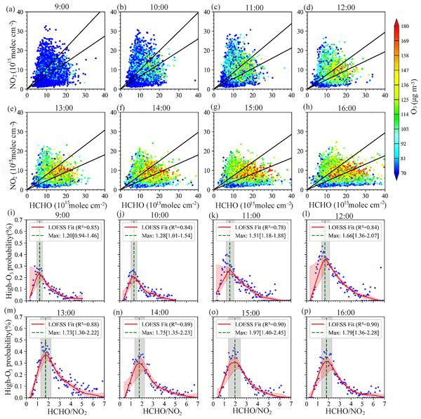
Ozone pollution is a growing issue in China, with levels increasing steadily from 2020 to 2024. This study uses satellite data to explore how different pollutants interact to form ozone. The results show that urban areas shift their pollution control strategies throughout the day. These findings suggest that targeting specific pollutants at different times could significantly improve air quality and help reduce harmful ozone pollution in China.
Zhengyan Zhang, Yan-An Liu, Xinjian Ma, Zhenglong Li, Pengbo Xu, Juan Zhang, Min Min, Di Di, Bo Li, and Jun Li
Earth Syst. Sci. Data, 18, 1683–1701, https://doi.org/10.5194/essd-18-1683-2026, https://doi.org/10.5194/essd-18-1683-2026, 2026
Short summary
Short summary
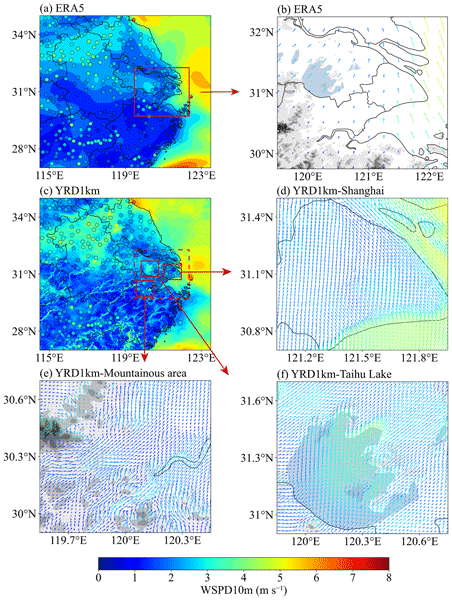
We developed a three-dimensional wind dataset for the Yangtze River Delta with hourly information at one-kilometer resolution for the summers from 2021 to 2023. Using atmospheric modeling combined with ground observations and land surface data, the dataset represents local wind behavior more accurately than existing products. It supports studies of extreme weather, air pollution transport, wind energy planning, and low-altitude airspace safety in rapidly urbanizing regions.
Xinran Xia, Min Min, Jun Li, Yiming Zhao, Ling Gao, and Bo Li
EGUsphere, https://doi.org/10.5194/egusphere-2025-2928, https://doi.org/10.5194/egusphere-2025-2928, 2025
Preprint archived
Short summary
Short summary
New ML method fuses GEO hyperspectral & imager data to improve nighttime cloud retrievals. Achieves ~10 % better accuracy (CER:9.73μm, COT:6.09 errors), especially for thin clouds. Maintains day-night continuity, aids weather/climate monitoring.

Mengyuan Wang, Min Min, Jun Li, Han Lin, Yongen Liang, Binlong Chen, Zhigang Yao, Na Xu, and Miao Zhang
Atmos. Chem. Phys., 24, 14239–14256, https://doi.org/10.5194/acp-24-14239-2024, https://doi.org/10.5194/acp-24-14239-2024, 2024
Short summary
Short summary
Although machine learning technology is advanced in the field of satellite remote sensing, the physical inversion algorithm based on cloud base height can better capture the daily variation in the characteristics of the cloud base.
Jian Liu, Jingjing Yu, Chuyong Lin, Min He, Haiyan Liu, Wei Wang, and Min Min
Earth Syst. Sci. Data, 16, 4949–4969, https://doi.org/10.5194/essd-16-4949-2024, https://doi.org/10.5194/essd-16-4949-2024, 2024
Short summary
Short summary
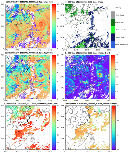
The Japanese Himawari-8 and Himawari-9 (H8/9) geostationary (GEO) satellites are strategically positioned over the South China Sea (SCS), spanning from 3 November 2022 to the present. They mainly provide cloud mask, fraction, height, phase, optical, and microphysical property; layered precipitable water; and sea surface temperature products within a temporal resolution of 10 min and a gridded resolution of 0.05° × 0.05°.
Xinran Xia, Rubin Jiang, Min Min, Shengli Wu, Peng Zhang, and Xiangao Xia
Earth Syst. Sci. Data Discuss., https://doi.org/10.5194/essd-2024-395, https://doi.org/10.5194/essd-2024-395, 2024
Revised manuscript not accepted
Short summary
Short summary
Based on the MicroWave Radiation Imager aboard FY-3 series satellites, we developed a global terrestrial precipitable water vapor dataset from 2012 to 2020. This dataset overcomes the limitations of infrared observations and provides accurate, all-weather PWV data ,spanning all types of land surface. Researchers are expected to leverage it to explore the role of water vapor in weather patterns, refine precipitation forecasting, and validate climate simulations.
Mengyuan Wang, Min Min, Jun Li, Han Lin, Yongen Liang, Binlong Chen, Zhigang Yao, Na Xu, and Miao Zhang
EGUsphere, https://doi.org/10.5194/egusphere-2023-2843, https://doi.org/10.5194/egusphere-2023-2843, 2023
Preprint archived
Short summary
Short summary
Our study primarily addresses the feasibility of employing advanced machine learning and physics-based algorithms to capture the diurnal variations in cloud base height parameters using geostationary meteorological satellite remote sensing. The results indicated that the caution is warranted when utilizing cloud base property products trained on satellite and laser radar data for climate research. Fixed training samples might obscure the pronounced diurnal variations in cloud base heights.
Pan Xia, Min Min, Jun Li, Na Xu, Di Di, Yan-An Liu, Gang Wang, Zijing Liu, and Yongqiang Chen
Earth Syst. Sci. Data Discuss., https://doi.org/10.5194/essd-2026-606, https://doi.org/10.5194/essd-2026-606, 2026
Preprint under review for ESSD
Short summary
Short summary
This study presents a validated FY-4B minute-scale mesoscale AMV dataset for 15 tropical cyclones (2022–2025), offering 3-km VIS and 24-km IRX vectors at 1/2/6/7 min intervals. It provides unprecedented observations of inner-core, rainband, and outflow structures. Evaluated against radiosondes and ERA5, VIS biases are 2.34 and 1.62 m/s, and IRX biases are 2.21 and 0.31 m/s, respectively. The dataset supports detailed monitoring of TC structural evolution and short-term intensity change.
Cheng Huang, Junjie Wang, Yinbao Jin, Min Min, Qi Fan, and Jhoon Kim
Atmos. Chem. Phys., 26, 10221–10240, https://doi.org/10.5194/acp-26-10221-2026, https://doi.org/10.5194/acp-26-10221-2026, 2026
Short summary
Short summary
Ozone pollution is a growing issue in China, with levels increasing steadily from 2020 to 2024. This study uses satellite data to explore how different pollutants interact to form ozone. The results show that urban areas shift their pollution control strategies throughout the day. These findings suggest that targeting specific pollutants at different times could significantly improve air quality and help reduce harmful ozone pollution in China.
Ruijie Zhang, Lu Zhang, Xingying Zhang, Peng Zhang, Minqiang Zhou, Xifeng Cao, Chonghui Cheng, and Huirong Yang
EGUsphere, https://doi.org/10.5194/egusphere-2026-3007, https://doi.org/10.5194/egusphere-2026-3007, 2026
Short summary
Short summary
Measuring carbon dioxide from individual power plants is important for checking emissions, but satellite observations face a trade-off: sharper views are often noisier, while averaging many measurements can blur the plume. We used China’s Daqi-1 satellite data, simulations, and real power plant cases to test how much averaging is useful. We found that no single setting is best. Reliable estimates must balance noise reduction, plume detail, and the number of useful observations.
Xiaozhong Cao, Qiyun Guo, Haowen Luo, Jincheng Wang, Rongkang Yang, Die Xiao, Yinfeng Liu, Zhongliang Sun, Shijun Liu, Sijie Chen, Anfan Huang, Guo Jianping, and Peng Zhang
Atmos. Meas. Tech., 19, 3231–3251, https://doi.org/10.5194/amt-19-3231-2026, https://doi.org/10.5194/amt-19-3231-2026, 2026
Short summary
Short summary
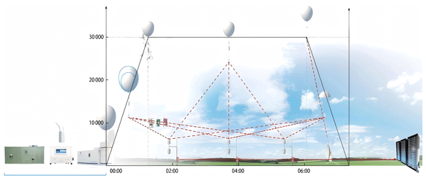
The Ascent-Drift-Descent Radiosonde System (ADDRS) represents an emerging cost-effective technology for upper-air measurements, Its 'Internet cloud + instrument terminal' design enables targeted observations for extreme weather research. Initial data application shows high potential for numerical weather prediction, The pilot application of ADDRS is list in the World Meteorological Organization Region II Coordination 2025-2027 demonstration project (No.RA II-18-I-DP-2).
Panxiang Zhang, Peng Zhang, Gang Ma, Rui Li, Lu Lee, Wenguang Bai, and Chengli Qi
EGUsphere, https://doi.org/10.5194/egusphere-2025-5121, https://doi.org/10.5194/egusphere-2025-5121, 2026
Short summary
Short summary
To enhance atmospheric transmittance accuracy in strong water vapor absorption bands, this study proposes an optimized scheme for the fast transmittance algorithm applied to the Hyperspectral Infrared Atmospheric Sounder-II. It introduces a transmittance threshold for sample selection and a weighted least squares regression with transmittance weighting. Validation against line-by-line models and observations shows significant improvements in forward model accuracy and stability at 6.7 μm.
Zhengyan Zhang, Yan-An Liu, Xinjian Ma, Zhenglong Li, Pengbo Xu, Juan Zhang, Min Min, Di Di, Bo Li, and Jun Li
Earth Syst. Sci. Data, 18, 1683–1701, https://doi.org/10.5194/essd-18-1683-2026, https://doi.org/10.5194/essd-18-1683-2026, 2026
Short summary
Short summary
We developed a three-dimensional wind dataset for the Yangtze River Delta with hourly information at one-kilometer resolution for the summers from 2021 to 2023. Using atmospheric modeling combined with ground observations and land surface data, the dataset represents local wind behavior more accurately than existing products. It supports studies of extreme weather, air pollution transport, wind energy planning, and low-altitude airspace safety in rapidly urbanizing regions.
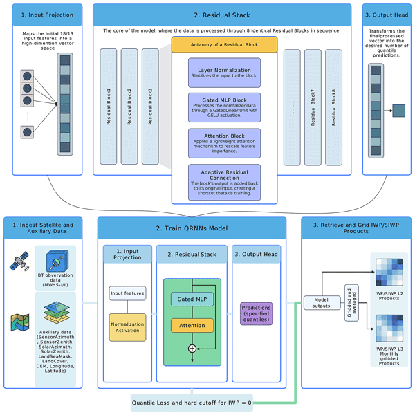
Yifan Yang, Tingfeng Dou, Gaojie Xu, Rui Zhou, Bo Li, Letu Husi, Wenyu Wang, and Cunde Xiao
Earth Syst. Sci. Data, 18, 1287–1305, https://doi.org/10.5194/essd-18-1287-2026, https://doi.org/10.5194/essd-18-1287-2026, 2026
Short summary
Short summary
We developed "FYAI" (Fengyun Satellite-Based Dataset for Atmospheric Ice Water Path), a fifteen-year dataset (2010–2024) derived from Chinese Fengyun satellites. Using artificial intelligence, we mapped global atmospheric ice. This continuous record fills critical gaps in observation. It provides scientists with a vital tool to improve weather forecasts and better understand how atmospheric ice interacts with the global climate system.
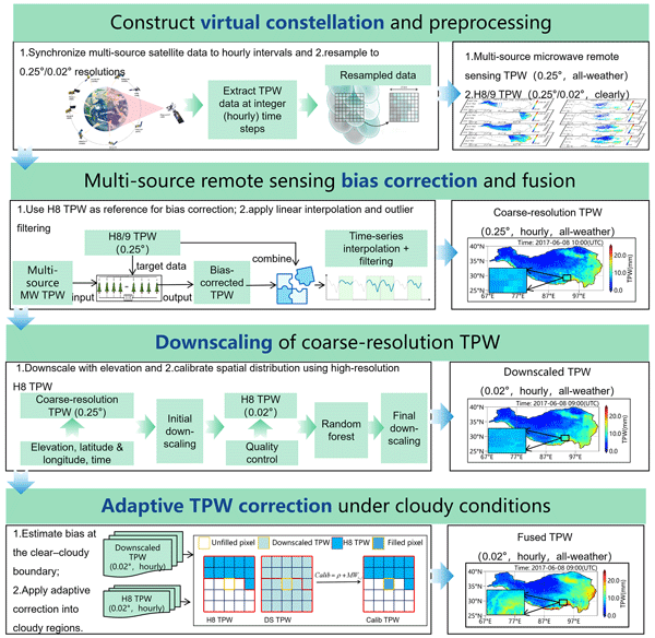
Qixiang Sun, Husi Letu, Yongqian Wang, Peng Zhang, Hong Liang, Chong Shi, Shuai Yin, Jiancheng Shi, and Dabin Ji
Earth Syst. Sci. Data, 18, 371–395, https://doi.org/10.5194/essd-18-371-2026, https://doi.org/10.5194/essd-18-371-2026, 2026
Short summary
Short summary
The Tibetan Plateau plays a vital role in Asia’s water cycle, but tracking water vapor in this mountainous region is difficult, especially under cloudy conditions. We developed a new satellite-based method to generate hourly water vapor data at 0.02-degree resolution from 2016 to 2022, now available at https://doi.org/10.11888/Atmos.tpdc.301518, which improves accuracy and reveals fine-scale moisture transport critical for understanding rainfall and extreme weather.
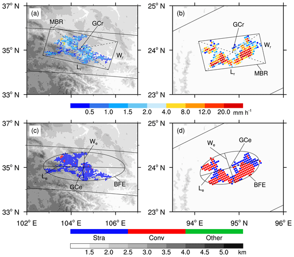
Zhenhao Wu, Jian Shang, Chunguan Cui, Peng Zhang, Songyan Gu, Lin Chen, and Yunfei Fu
Earth Syst. Sci. Data, 17, 5137–5148, https://doi.org/10.5194/essd-17-5137-2025, https://doi.org/10.5194/essd-17-5137-2025, 2025
Short summary
Short summary
We have established a new dataset of rain cell precipitation parameters and visible-infrared and microwave signals by combining multi-instrument observation data from the Tropical Rainfall Measuring Mission (TRMM). The purpose of this dataset is to promote the three-dimensional studies of rain cell precipitation systems and to reveal the spatial and temporal variations in their scale, morphology, and intensity.
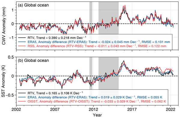
Yixiao Fu, Cheng-Zhi Zou, Peng Zhang, Banghai Wu, Shengli Wu, Shi Liu, and Yu Wang
Earth Syst. Sci. Data, 17, 4651–4670, https://doi.org/10.5194/essd-17-4651-2025, https://doi.org/10.5194/essd-17-4651-2025, 2025
Short summary
Short summary
This study presents a climate data record (CDR) of atmospheric column water vapor and sea surface temperature using over two decades of stable-orbit satellite-based passive microwave imagery observations. The evaluation results show that the CDR has long-term consistency and continuity, and is more accurate than other similar products in climate covariability, suggesting that the CDR is suitable for climate change research and for constraining climate model simulations.
Yunfan Yang, Wei Han, Haofei Sun, Jun Li, Jiapeng Yan, and Zhiqiu Gao
Atmos. Meas. Tech., 18, 4249–4269, https://doi.org/10.5194/amt-18-4249-2025, https://doi.org/10.5194/amt-18-4249-2025, 2025
Short summary
Short summary
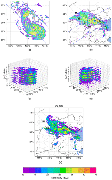
Our research improves satellite-based precipitation monitoring by using deep learning to reconstruct radar observations from passive microwave radiances. Active radar is costly, so we focus on a more accessible approach. Using data from the Fengyun-3G satellite, we successfully tracked severe weather like Typhoon Khanun and heavy rainfall in Beijing in 2023. This method enhances global precipitation data and helps better understand extreme weather.
Xinran Xia, Min Min, Jun Li, Yiming Zhao, Ling Gao, and Bo Li
EGUsphere, https://doi.org/10.5194/egusphere-2025-2928, https://doi.org/10.5194/egusphere-2025-2928, 2025
Preprint archived
Short summary
Short summary
New ML method fuses GEO hyperspectral & imager data to improve nighttime cloud retrievals. Achieves ~10 % better accuracy (CER:9.73μm, COT:6.09 errors), especially for thin clouds. Maintains day-night continuity, aids weather/climate monitoring.
Xinyu Li, Lin Zhu, Hongfu Sun, Jun Li, Ximing Lv, Chengli Qi, and Huanhuan Yan
Atmos. Meas. Tech., 18, 2333–2352, https://doi.org/10.5194/amt-18-2333-2025, https://doi.org/10.5194/amt-18-2333-2025, 2025
Short summary
Short summary
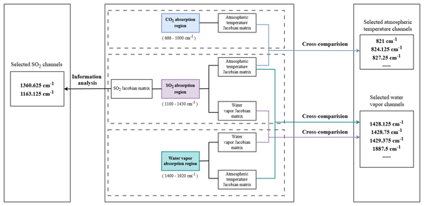
This paper proposes a novel methodology for selecting sulfur-dioxide-sensitive channels from FY-3E/HIRAS-II hyperspectral IR atmospheric sensors to quantitatively monitor volcanic sulfur dioxide. This methodology considers the interference of atmospheric temperature, humidity, and surface temperature with sulfur dioxide detection and retrieval, laying the groundwork for developing a more accurate and flexible volcanic sulfur dioxide retrieval algorithm under different atmospheric conditions.
Mengyuan Wang, Min Min, Jun Li, Han Lin, Yongen Liang, Binlong Chen, Zhigang Yao, Na Xu, and Miao Zhang
Atmos. Chem. Phys., 24, 14239–14256, https://doi.org/10.5194/acp-24-14239-2024, https://doi.org/10.5194/acp-24-14239-2024, 2024
Short summary
Short summary
Although machine learning technology is advanced in the field of satellite remote sensing, the physical inversion algorithm based on cloud base height can better capture the daily variation in the characteristics of the cloud base.
Jian Liu, Jingjing Yu, Chuyong Lin, Min He, Haiyan Liu, Wei Wang, and Min Min
Earth Syst. Sci. Data, 16, 4949–4969, https://doi.org/10.5194/essd-16-4949-2024, https://doi.org/10.5194/essd-16-4949-2024, 2024
Short summary
Short summary
The Japanese Himawari-8 and Himawari-9 (H8/9) geostationary (GEO) satellites are strategically positioned over the South China Sea (SCS), spanning from 3 November 2022 to the present. They mainly provide cloud mask, fraction, height, phase, optical, and microphysical property; layered precipitable water; and sea surface temperature products within a temporal resolution of 10 min and a gridded resolution of 0.05° × 0.05°.
Xinran Xia, Rubin Jiang, Min Min, Shengli Wu, Peng Zhang, and Xiangao Xia
Earth Syst. Sci. Data Discuss., https://doi.org/10.5194/essd-2024-395, https://doi.org/10.5194/essd-2024-395, 2024
Revised manuscript not accepted
Short summary
Short summary
Based on the MicroWave Radiation Imager aboard FY-3 series satellites, we developed a global terrestrial precipitable water vapor dataset from 2012 to 2020. This dataset overcomes the limitations of infrared observations and provides accurate, all-weather PWV data ,spanning all types of land surface. Researchers are expected to leverage it to explore the role of water vapor in weather patterns, refine precipitation forecasting, and validate climate simulations.
Mengyuan Wang, Min Min, Jun Li, Han Lin, Yongen Liang, Binlong Chen, Zhigang Yao, Na Xu, and Miao Zhang
EGUsphere, https://doi.org/10.5194/egusphere-2023-2843, https://doi.org/10.5194/egusphere-2023-2843, 2023
Preprint archived
Short summary
Short summary
Our study primarily addresses the feasibility of employing advanced machine learning and physics-based algorithms to capture the diurnal variations in cloud base height parameters using geostationary meteorological satellite remote sensing. The results indicated that the caution is warranted when utilizing cloud base property products trained on satellite and laser radar data for climate research. Fixed training samples might obscure the pronounced diurnal variations in cloud base heights.
Ying Chen, Ruibo Lei, Xi Zhao, Shengli Wu, Yue Liu, Pei Fan, Qing Ji, Peng Zhang, and Xiaoping Pang
Earth Syst. Sci. Data, 15, 3223–3242, https://doi.org/10.5194/essd-15-3223-2023, https://doi.org/10.5194/essd-15-3223-2023, 2023
Short summary
Short summary
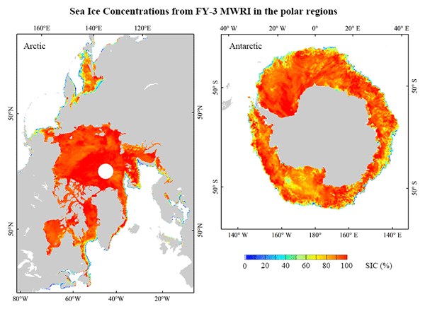
The sea ice concentration product derived from the Microwave Radiation Image sensors on board the FengYun-3 satellites can reasonably and independently identify the seasonal and long-term changes of sea ice, as well as extreme cases of annual maximum and minimum sea ice extent in polar regions. It is comparable with other sea ice concentration products and applied to the studies of climate and marine environment.
You Zhao, Chao Liu, Di Di, Ziqiang Ma, and Shihao Tang
Atmos. Meas. Tech., 15, 2791–2805, https://doi.org/10.5194/amt-15-2791-2022, https://doi.org/10.5194/amt-15-2791-2022, 2022
Short summary
Short summary
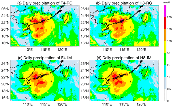
A typhoon is a high-impact atmospheric phenomenon that causes most significant socioeconomic damage, and its precipitation observation is always needed for typhoon characteristics and disaster prevention. This study developed a typhoon precipitation fusion method to combine observations from satellite radiometers, rain gauges and reanalysis to provide much improved typhoon precipitation datasets.
Yungang Wang, Liping Fu, Fang Jiang, Xiuqing Hu, Chengbao Liu, Xiaoxin Zhang, Jiawei Li, Zhipeng Ren, Fei He, Lingfeng Sun, Ling Sun, Zhongdong Yang, Peng Zhang, Jingsong Wang, and Tian Mao
Atmos. Meas. Tech., 15, 1577–1586, https://doi.org/10.5194/amt-15-1577-2022, https://doi.org/10.5194/amt-15-1577-2022, 2022
Short summary
Short summary
Far-ultraviolet (FUV) airglow radiation is particularly well suited for space-based remote sensing. The Ionospheric Photometer (IPM) instrument carried aboard the Feng Yun 3-D satellite measures the spectral radiance of the Earth FUV airglow. IPM is a tiny, highly sensitive, and robust remote sensing instrument. Initial results demonstrate that the performance of IPM meets the designed requirement and therefore can be used to study the thermosphere and ionosphere in the future.
Cited articles
AERIS/ICARE Data and Services Center: CALIOP, 05kmCPro.v4.21, https://doi.org/10.5067/CALIOP/CALIPSO/CAL_LID_L2_05kmCPro-Standard-V4-21 available at: https://www.icare.univ-lille.fr/asd-content/archive/?dir=/CALIO P/05kmCPro.v4.21, last access: 22 September 2026.
Berk, A., Anderson, G. P., and Acharya, P. K.: MODTRAN® 5.3.2 User's Manual, Spectral Sciences, Inc., Burlington, MA, USA, and Air Force Research Laboratory, Space Vehicles Directorate, Kirtland AFB, NM, USA, http://modtran.spectral.com/ (last access: 22 September 2026), May 2013.
Bhadra, S., Sagan, V., Sarkar, S., Braud, M., Mockler, T. C., and Eveland, A. L.: PROSAIL-Net: A transfer learning-based dual stream neural network to estimate leaf chlorophyll and leaf angle of crops from UAV hyperspectral images, ISPRS J. Photogramm., 210, 1–24, https://doi.org/10.1016/j.isprsjprs.2024.02.020, 2024.
Caruana, R.: Multitask Learning, Mach. Learn., 28, 41–75, https://doi.org/10.1023/A:1007379606734, 1997.
Chen, Y., Weng, F., Han, Y., and Liu, Q.: Planck-Weighted Transmittance and Correction of Solar Reflection for Broadband Infrared Satellite Channels, J. Atmos. Ocean. Tech., 29, 382–396, https://doi.org/10.1175/JTECH-D-11-00102.1, 2012.
Choi, T., Cao, C., Blonski, S., Shao, X., and Wang, W.: NOAA-20 VIIRS On-Orbit Reflective Solar Band Radiometric Calibration Five-Year Update, IEEE T. Geosci. Remote, 62, 1–10, https://doi.org/10.1109/TGRS.2024.3363661, 2024.
Doelling, D. R., Daniel, M., Benjamin, R. S., Rajendra, B., and Arun, G.: The characterization of deep convective clouds as an invariant calibration target and as a visible calibration technique, IEEE T. Geosci. Remote, 51, 1147–1159, 2013.
Drusch, M., Del Bello, U., Carlier, S., Colin, O., Fernandez, V., Gascon, F., Hoersch, B., Isola, C., Laberinti, P., Martimort, P., Meygret, A., Spoto, F., Sy, O., Marchese, F., and Bargellini, P.: Sentinel-2: ESA's Optical High-Resolution Mission for GMES Operational Services, Remote Sens. Environ., 120, 25–36, https://doi.org/10.1016/j.rse.2011.11.026, 2012.
Endres, D. M. and Schindelin, J. E.: A new metric for probability distributions, IEEE T. Inform. Theory, 49, 1858–1860, https://doi.org/10.1109/tit.2003.813506, 2006.
Fu, D., Shi, H., Gueymard, C. A., Yang, D., Zheng, Y., Che, H., Fan, X., Han, X., Gao, L., Bian, J., Duan, M., and Xia, X.: A Deep-Learning and Transfer-Learning Hybrid Aerosol Retrieval Algorithm for FY4-AGRI: Development and Verification over Asia, Engineering, 38, 186–198, 2024.
Gao, B.-C., Goetz, A. F. H., and Wiscombe, W. J.: Cirrus cloud detection from Airborne Imaging Spectrometer data using the 1.38 µm water vapor band, Geophys. Res. Lett., 20, 301–304, https://doi.org/10.1029/93GL00106, 1993.
He, X., Xu, N., Feng, X., Hu, X., Xu, H., and Peng, Y.: Assessing radiometric calibration of FY- 4A/AGRI thermal infrared channels using CrIS and IASI, IEEE T. Geosci. Remote, https://doi.org/10.1109/TGRS.2021.3111975, 2021.
Hewison, T., Wu, X., Yu, F., and Hu, X.: GSICS inter-calibration of infrared channels of geostationary imagers using Metop/IASI, IEEE T. Geosci. Remote, 51, 1160–1170, 2013.
Hinton, G. E., Osindero, S., and Teh, Y.-W.: A Fast Learning Algorithm for Deep Belief Nets, Neural Comput., 18, 1527–1554, https://doi.org/10.1162/neco.2006.18.7.1527, 2006.
Hocking, J., Vidot, J., Brunel, P., Roquet, P., Silveira, B., Turner, E., and Lupu, C.: A new gas absorption optical depth parameterisation for RTTOV version 13, Geosci. Model Dev., 14, 2899–2915, https://doi.org/10.5194/gmd-14-2899-2021, 2021.
Jablonka, K. M., Schwaller, P., Ortega-Guerrero, A., and Smit, B.: Leveraging large language models for predictive chemistry, Nature Machine Intelligence, 6, 161–169, https://doi.org/10.1038/s42256-023-00788-1, 2024.
Joseph, S., Parthi, A. G., Maruthavanan, D., Jayaram, V., Veerapaneni, P. K., and Parlapalli, V.: Transfer Learning in Natural Language Processing, 2024 7th International Conference on Information and Communications Technology (ICOIACT), 20–21 November 2024, 30–36, https://doi.org/10.1109/ICOIACT64819.2024.10912895, 2024.
Kotchenova, S. Y., Vermote, E. F., Matarrese, R., and Klemm, J. F. J.: Validation of a vector version of the 6S radiative transfer code for atmospheric correction of satellite data. Part I: Path radiance, Appl. Opt., 45, 6762–6774, https://doi.org/10.1364/AO.45.006762, 2006.
Krizhevsky, A., Sutskever, I., and Hinton, G. E.: ImageNet Classification with Deep Convolutional Neural Networks, Adv. Neur. In., 25, 1097–1105, 2012.
Kühnlein, M., Appelhans, T., Thies, B., and Nauß, T.: Precipitation estimates from MSG SEVIRI daytime, nighttime, and twilight data with random forests, J. Appl. Meteorol. Clim., 53, 2457–2480, https://doi.org/10.1175/JAMC-D-14-0082.1, 2014a.
Kühnlein, M., Appelhans, T., Thies, B., and Nauss, T.: Improving the accuracy of rainfall rates from optical satellite sensors with machine learning – A random forests-based approach applied to MSG SEVIRI, Remote Sens. Environ., 141, 129–143, https://doi.org/10.1016/j.rse.2013.10.026, 2014b.
LeCun, Y., Bengio, Y., and Hinton, G.: Deep learning, Nature, 521, 436–444, https://doi.org/10.1038/nature14539, 2015.
Lee, J., Moon, I.-J., Im, J., Kim, D.-H., and Jung, H.: Multi-task feature transfer deep learning-based tropical cyclone center estimation (MFT–TC) using geostationary satellite observations, Weather and Climate Extremes, 49, 100796, https://doi.org/10.1016/j.wace.2025.100796, 2025.
Li, J., Menzel, W. P., Schmit, T. J., and Schmetz, J.: Applications of geostationary hyperspectral infrared sounder observations – progress, challenges, and future perspectives, B. Am. Meteorol. Soc., https://doi.org/10.1175/BAMS-D-21-0328.1, 2022.
Li, J., Zhang, F., Li, W., Tong, X., Pan, B., Li, J., Lin, H., Letu, H., and Mustafa, F.: Transfer-Learning-Based Approach to Retrieve the Cloud Properties Using Diverse Remote Sensing Datasets, IEEE T. Geosci. Remote, 61, 1–10, https://doi.org/10.1109/TGRS.2023.3318374, 2023.
Li, J., Zheng, J., Li, B., Min, M., Liu, Y., Liu, C.-Y., Li, Z., Menzel, W. P., Schmit, T. J., Cintineo, J. L., Lindstrom, S., Bachmeier, S., Xue, Y., Ma, Y., Di, D., and Lin, H.: Quantitative applications of weather satellite data in nowcasting: progress and challenges, J. Meteorol. Res., 38, 399–413, https://doi.org/10.1007/s13351-024-3138-6 2024.
Li, L., Han, L., Ye, Y., Xiang, Y., and Zhang, T.: Deep learning in remote sensing image matching: A survey, ISPRS J. Photogramm., 225, 88–112, https://doi.org/10.1016/j.isprsjprs.2025.04.001, 2025.
Lin, H., Li, J., Min, M., Zhang, F., Wang, K., and Wu, Q.: CLANN: Cloud amount neural network for estimating 3D cloud from geostationary satellite imager, Remote Sens. Environ., 318, 114600, https://doi.org/10.2139/ssrn.4914490, 2025.
Liu, J., Yu, J., Lin, C., He, M., Liu, H., Wang, W., and Min, M.: Near-real-time atmospheric and oceanic science products of Himawari-8 and Himawari-9 geostationary satellites over the South China Sea, Earth Syst. Sci. Data, 16, 4949–4969, https://doi.org/10.5194/essd-16-4949-2024, 2024.
Ma, Y., Chen, S., Ermon, S., and Lobell, D. B.: Transfer learning in environmental remote sensing, Remote Sens. Environ., 301, 113924, https://doi.org/10.1016/j.rse.2023.113924, 2024.
Ma, Z., Li, J., Han, W., Li, Z., Zeng, Q., Menzel, W. P., Schmit, T. J., Di, D., and Liu, C.-Y.: Four‐dimensional wind fields from geostationary hyperspectral infrared sounder radiance measurements with high temporal resolution, Geophys. Res. Lett., 48, e2021GL093794, https://doi.org/10.1029/2021GL093794, 2021.
Massey Jr., F. J.: The Kolmogorov–Smirnov test for goodness of fit, J. Am. Stat. Assoc., 46, 68–78, https://doi.org/10.2307/2280095, 1951.
Mateo-García, G., Laparra, V., López-Puigdollers, D., and Gómez-Chova, L.: Transferring deep learning models for cloud detection between Landsat-8 and Proba-V, ISPRS J. Photogramm., 160, 1–17, https://doi.org/10.1016/j.isprsjprs.2019.11.024, 2020.
Matricardi, M.: A principal component based version of the RTTOV fast radiative transfer model, Q. J. Roy. Meteor. Soc., 136, 1823–1835, https://doi.org/10.1002/qj.680, 2010.
McGovern, A., Chase, R. J., Flora, M., Gagne, D. J., Lagerquist, R., Potvin, C. K., Snook, N., and Loken, E.: A Review of Machine Learning for Convective Weather, Artificial Intelligence for the Earth Systems, 2, e220077, https://doi.org/10.1175/AIES-D-22-0077.1, 2023.
Mémoli, F.: Gromov–Wasserstein Distances and the Metric Approach to Object Matching, Found. Comput. Math., 11, 417–487, https://doi.org/10.1007/s10208-011-9093-5, 2011.
Miller, L., Pelletier, C., and Webb, G. I.: Deep Learning for Satellite Image Time Series Analysis: A Review, arXiv [preprint], https://doi.org/10.48550/arXiv.2404.03936, 2024.
Min, M., Li, J., Wang, F., Liu, Z., and Menzel, W. P.: Retrieval of cloud top properties from advanced geostationary satellite imager measurements based on machine learning algorithms, Remote Sens. Environ., 239, 111616, https://doi.org/10.1016/j.rse.2019.111616 2020.
Min, M., Chen, B., Xu, N., He, X., Wei, X., and Wang, M.: Nonnegligible diurnal and long-term variation characteristics of the calibration biases in Fengyun-4A/AGRI infrared channels based on the oceanic drifter data, IEEE T. Geosci. Remote, 60, 1–15, https://doi.org/10.1109/TGRS.2022.3160450, 2022.
Min, M., Deng, J., Liu, C., Lu, N., Hu, X., Chen, L., Guo, J., Zhang, P., Lu, Q., and Wang, L.: An investigation of the implications of lunar illumination spectral changes for Day/Night Band based cloud property retrieval due to lunar phase transition, J. Geophys. Res.-Atmos., 122, 9233–9244, https://doi.org/10.1002/2017JD027117, 2017a.
Min, M., Bai, C., Guo, J., Sun, F., Liu, C., Wang, F., Xu, H., Tang, S., Li, B., Di, D., Dong, L., and Li, J.: Estimating summertime precipitation from Himawari-8 and global forecast system based on machine learning, IEEE T. Geosci. Remote, 57, 2557–2570, https://doi.org/10.1109/TGRS.2018.2874950, 2019.
Min, M., Wu, C., Li, C., Liu, H., Xu, N., Wu, X., Chen, L., Wang, F., Sun, F., Qin, D., Wang, X., Li, B., Zheng, Z., Cao, G., and Dong, L.: Developing the science product algorithm testbed for Chinese next-generation geostationary meteorological satellites: FengYun-4 series, J. Meteorol. Res., 31, 708–719, https://doi.org/10.1007/s13351-017-6161-z, 2017b.
Nowakowski, A., Mrziglod, J., Spiller, D., Bonifacio, R., Ferrari, I., Mathieu, P. P., Garcia-Herranz, M., and Kim, D.-H.: Crop type mapping by using transfer learning, Int. J. Appl. Earth Obs., 98, 102313, https://doi.org/10.1016/j.jag.2021.102313, 2021.
Pan, S. J. and Yang, Q.: A Survey on Transfer Learning, IEEE T. Knowl. Data En., 22, 1345–1359, https://doi.org/10.1109/TKDE.2009.191, 2010.
Pearlman, A., Pogorzala, D., and Cao, C.: GOES-R Advanced Baseline Imager: spectral response functions and radiometric biases with the NPP Visible Infrared Imaging Radiometer Suite evaluated for desert calibration sites, Appl. Opt., 52, 7660–7668, https://doi.org/10.1364/AO.52.007660, 2013.
Platnick, S., Meyer, K. G., King, M. D., Wind, G., Amarasinghe, N., Marchant, B., Arnold, G. T., Zhang, Z., Hubanks, P. A., Holz, R. E., Yang, P., Ridgway, W. L., and Riedi, J.: The MODIS cloud optical and microphysical products: Collection 6 updates and examples from Terra and Aqua, IEEE T. Geosci. Remote, 55, 502–525, https://doi.org/10.1109/TGRS.2016.2610522, 2017.
Ronneberger, O., Fischer, P., and Brox, T.: U-Net: Convolutional Networks for Biomedical Image Segmentation, Medical Image Computing and Computer-Assisted Intervention – MICCAI 2015, Springer, Cham, 234–241, https://doi.org/10.1007/978-3-319-24574-4_28, 2015.
Schmit, T. J., Griffith, P., Gunshor, M. M., Daniels, J. M., Goodman, S. J., and Lebair, W. J.: A closer look at the ABI on the GOES-R Series, B. Am. Meteorol. Soc., 98, 681–698 https://doi.org/10.1175/BAMS-D-15-00230.1, 2017.
Skofronick-Jackson, G., Petersen, W. A., Berg, W., Kidd, C., Stocker, E., Kirschbaum, D. B., and Huffman, G. J.: The Global Precipitation Measurement (GPM) Mission for Science and Society, B. Am. Meteorol. Soc., 98, 1679–1695, 2017.
Teixeira, J., Wilson, R. C., and Thrastarson, H. Th.: Direct observational evidence from space of the effect of CO2 increase on longwave spectral radiances: the unique role of high-spectral-resolution measurements, Atmos. Chem. Phys., 24, 6375–6383, https://doi.org/10.5194/acp-24-6375-2024, 2024.
Wang, C. and Li, X.: Developing a Data-Driven Transfer Learning Model to Locate Tropical Cyclone Centers on Satellite Infrared Imagery, J. Atmos. Ocean. Tech., 40, 1605–1618, https://doi.org/10.1175/JTECH-D-23-0026.1, 2023.
Wang, C., Tang, G., Xiong, W., Ma, Z., and Zhu, S.: Infrared precipitation estimation using convolutional neural network for FengYun satellites, J. Hydrol., 603, 127113, https://doi.org/10.1016/j.jhydrol.2021.127113, 2021.
Wang, M., Min, M., Li, J., Lin, H., Liang, Y., Chen, B., Yao, Z., Xu, N., and Zhang, M.: Technical note: Applicability of physics-based and machine-learning-based algorithms of a geostationary satellite in retrieving the diurnal cycle of cloud base height, Atmos. Chem. Phys., 24, 14239–14256, https://doi.org/10.5194/acp-24-14239-2024, 2024.
Wang, W., Brönnimann, S., Zhou, J., Li, S., and Wang, Z.: Near-surface air temperature estimation for areas with sparse observations based on transfer learning, ISPRS J. Photogramm., 220, 712–727, https://doi.org/10.1016/j.isprsjprs.2025.01.021, 2025.
Xia, P., Meng, D., Min, M., Li, J., Liu, Y.-A., Yang, X., and Xu, N.: Impacts of Fengyun-4B satellite rapid imaging-derived atmospheric motion vectors on typhoon forecasts, J. Geophys. Res.-Atmos., 130, e2025JD044269, https://doi.org/10.1029/2025JD044269, 2025.
Xia, P., Zhang, L., Min, M., Li, J., Wang, Y., Yu, Y., and Jia, S.: Accurate nowcasting of cloud cover at solar photovoltaic plants using geostationary satellite images, Nat. Commun., 15, 1–10, https://doi.org/10.1038/s41467-023-44666-1, 2024.
Xiong, X., Angal, A., Twedt, K. A., Chen, H., Link, D., Geng, X., Aldoretta, E., and Mu, Q.: MODIS Reflective Solar Bands On-Orbit Calibration and Performance, IEEE T. Geosci. Remote, 57, 6355–6371, https://doi.org/10.1109/TGRS.2019.2905792, 2019.
Yang, J., Zhang, Z., Wei, C., Lu, F., and Guo, Q.: Introducing the new generation of Chinese geostationary weather satellites, FengYun-4, B. Am. Meteorol. Soc., 98, 1637–1658, https://doi.org/10.1175/BAMS-D-16-0065.1, 2017.
Yu, Q., Min, M., Di, D., Zhao, Y., Li, G., Li, J., Wang, L., Hu, X., and Zhang, P.: Spectral-fidelity-preserving recalibration of reflective solar bands for MERSI-II onboard Fengyun-3D satellite, IEEE T. Geosci. Remote, 64, 4104116, https://doi.org/10.1109/TGRS.2026.3671371, 2026.
Zermatten, V., Castillo-Navarro, J., Marcos, D., and Tuia, D.: Learning transferable land cover semantics for open vocabulary interactions with remote sensing images, ISPRS J. Photogramm., 220, 621–636, https://doi.org/10.1016/j.isprsjprs.2025.01.006, 2025.
Zhang, C.-J., Wang, Y., Ma, L.-M., and Lu, X.-Q.: TCIC-SC-RNet: A Hybrid Model for TC Intensity Estimation Based on Transfer Learning, Weather Forecast., 39, 1469-1485, https://doi.org/10.1175/WAF-D-23-0080.1, 2024.
Zhou, J., Yang, Q., Liu, L., Kang, Y., Jia, X., Chen, M., Ghosh, R., Xu, S., Jiang, C., Guan, K., Kumar, V., and Jin, Z.: A deep transfer learning framework for mapping high spatiotemporal resolution LAI, ISPRS J. Photogramm., 206, 30–48, https://doi.org/10.1016/j.isprsjprs.2023.10.017, 2023.
Zhou, R., Pan, X., Xiaohu, Z., Na, X., and Min, M.: Research progress and prospects of atmospheric motion vector based on meteorological satelliteimages, Reviews of Geophysics and Planetary Physics, 55, 184–194, https://doi.org/10.19975/j.dqyxx.2022-077, 2024a (in Chinese).
Zhou, Y., Min, M., Li, J., Cao, Z., and Gao, L.: Enhanced typhoon center localization using geostationary satellite imagery, Geophys. Res. Lett., 51, e2024GL112252, https://doi.org/10.1029/2024GL112252, 2024b.
Short summary
A physics‑constrained transfer learning framework enables accurate radiance transformation across satellite sensors with different spectral response functions (SRFs). It integrates a Spectral‑Fidelity‑Preserving model from radiative transfer. Tests confirm robustness to calibration uncertainties and define SRF constraints. FY‑4A/B application improves cloud and precipitation retrievals, enabling operational algorithm transfer.
A physics‑constrained transfer learning framework enables accurate radiance transformation...
Altmetrics
Final-revised paper
Preprint