the Creative Commons Attribution 4.0 License.
the Creative Commons Attribution 4.0 License.
 | 18 Jun 2026
On the mechanisms that control the rainy season transition periods in the equatorial Congo Basin
Rong Fu
The equatorial Congo Basin (2° S–2° N, within the watershed), experiences two rainy seasons (RSs) in boreal spring and fall. Previously, the mechanisms driving the transitions to these RSs have not been investigated systematically. We show that both RS transitions begin with increases in the low-level atmospheric moisture transport from the Atlantic Ocean into the region, ∼1.5 months prior to the spring RS and ∼2 months prior to the fall RS. Evapotranspiration contributes the most to atmospheric moisture but does not change significantly throughout both transition periods. Sharp precipitation jumps 10 d before the start of the spring and fall RSs result from increasing boundary layer moisture that is orographically uplifted to the lower troposphere by the East African Rift and Congo Basin Cell ascending branch. This destabilizes the lower free troposphere, lowering the level of free convection and decreasing convective inhibition energy. Meanwhile, the African Easterly Jet-North and westerly return flow of the Congo Basin Cell induce vertical shear for the spring and fall RSs, respectively. Mid-tropospheric convergence strengthens due to return flow at ∼700 hPa from shallow meridional cells that direct low-level moisture towards the West African Heat Low prior to the spring RS, and to the Congo Air Boundary prior to the fall RS. Therefore, the RS onsets over the equatorial region are driven by seasonal changes in large-scale atmospheric circulation, contrasting with the pivotal role of increasing evapotranspiration in driving the transition to the RS onset over the southern Congo Basin.
- Article
(12783 KB) - Full-text XML
-
Supplement
(1788 KB) - BibTeX
- EndNote


The Congo Basin is a global water and carbon centre hosting vast rainforest, rivers, and precipitation (Brummett et al., 2009; Alsdorf et al., 2016; Xu et al., 2021). However, due to a lack of in situ data and limited infrastructure for research (Alsdorf et al., 2016), its meteorology and hydrological cycle have been less studied compared to the rest of Africa (Washington et al., 2013; Biasutti, 2019; Biasutti and Sobel, 2009; Lv et al., 2024; Yang et al., 2015; Thorncroft et al., 2011). Most studies examining process controls on seasonal rainfall have focused on specific months during the dry or rainy seasons (Nicholson, 2018, 2022; Cook and Vizy, 2022; Pokam et al., 2022). As such, the processes that control the transition to the rainy season onsets are virtually unknown. To fundamentally understand observed rainfall variability (Jiang et al., 2019; Zhou et al., 2014; Hua et al., 2016, 2018) within the equatorial region (defined as the area between 2° S–2° N, within the Congo Basin watershed), which experiences two rainy seasons, in boreal spring and fall, respectively (Fig. 1; Pokam et al., 2022; Nicholson, 2022), necessitates a full understanding of the mechanisms controlling its seasonal rainfall. In addition, understanding the mechanisms controlling the transition periods to the rainy seasons can aid identification of errors in climate models for seasonal rainy season onset forecasting, which is important climate information for agricultural production (Zampieri et al., 2023; Tchinda et al., 2022).
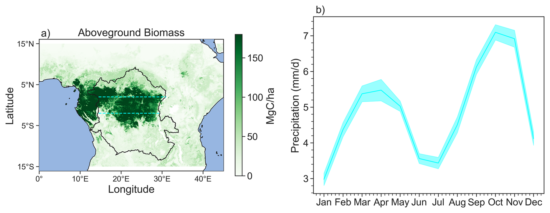
Figure 1(a) Above-ground biomass averaged between 2000–2019. Black outline denotes the Congo Basin watershed and the dashed lines at 2° S and 2° N represent the boundary of the equatorial region. (b) Precipitation climatology for the equatorial region. Shades are the standard error of the mean over of the different years.
The equatorial Congo Basin is unique in that its rainy seasons are not associated with strong near surface moisture flux convergence (Nicholson, 2018; Yang et al., 2015). Instead, near-surface moisture diverges away from the equatorial Congo basin, while mid-tropospheric moisture convergence appears to be central for rainfall formation (Nicholson, 2022). Atmospheric moisture for rainfall mainly comes from evapotranspiration (ET) both within Congo basin and from the adjacent land (e.g., Risi et al., 2013; Sorí et al., 2022; van der Ent et al., 2010; Worden et al., 2021b), though moisture transport from the surrounding oceans is important for its rainy seasons as well (e.g., Pokam et al., 2012). Several dynamic systems play important roles: a shallow zonal circulation referred to as the Congo Basin Cell (Longandjo and Rouault, 2020), the Congo Air Boundary (Howard and Washington, 2019) where warm, humid air from the Congo meets with relatively cool and dry air from the subtropical southern hemispheric Africa, the African Easterly Jet North and South (Nicholson, 2022; Chen, 2005; Kuete et al., 2020), a deep Walker-like zonal circulation (Longandjo and Rouault, 2020), and shallow meridional overturning cell (Longandjo and Rouault, 2024). Additionally, the East African Rift helps to induce uplift of near surface air and hence precipitation on the Congo Basin's eastern boundary (Nicholson, 2022).
However, the moisture contributions from land and terrestrial sources, and the presence and intensity of these dynamical systems vary throughout the year, likely leading to differences in the mechanisms controlling the transitions to the spring and fall rainy seasons. For example, the annual presence of the zonal Congo Basin Cell is debated. While Longandjo and Rouault (2020) argue that the cell is present year-round, Neupane (2016) and Cook and Vizy (2016) indicate that it is present only in the second half of the year. The Congo Air Boundary is strongest between August–October, and weakest between December-January (Howard and Washington, 2019). The AEJ-N is present year-round but moves latitudinally such that it is centred near the equator during the spring rainy season but centred outside of the Congo Basin around 10° N during the fall rainy season (Kuete et al., 2020; Nicholson and Grist, 2003). The AEJ-S only develops in the boreal fall in September (Kuete et al., 2020).
The influences of the heat lows over Sahara and Kalahari Desert, respectively, on the equatorial Congo region also change between the two rainy seasons, which is important for meridional moisture transport. During the fall rainy season, the southern African dry heat low is centred over the plateau region as the Angola heat low, but prior to the spring rainy season, a moist Angola thermal low migrates to the Kalahari region to become the Kalahari heat low (Howard and Washington, 2018; 2019; Attwood et al., 2024). Meanwhile, the Northern Hemisphere West African heat low is centred around the Sahelian region during the spring rainy season (around 10–15° N). During the fall rainy season, it transitions back towards the northern Congo Basin (Lavaysse et al., 2009). The different position of the heat lows can affect meridional moisture flow in and out of the basin (Cook et al., 2020). The mechanisms controlling the transition periods to the rainy seasons are likely related to the seasonal presence or movement of these key features.
ET provides about 70 % of the atmospheric moisture over the Congo basin (e.g., van der Ent et al., 2010; Risi et al., 2013; Worden et al., 2021b), and as much as 83 % of the atmospheric moisture in February and March, during the transition to spring rainy season. Worden and Fu (2025) further shows that, over the Southern Congo (2–14°S, 15–30° E), the increase of ET driven by increasing surface solar radiation plays a pivotal role to increase moisture in the atmospheric boundary layer, which, in turn, increases deep convection and leads to rainy season onset in boreal fall. On the other hand, most previous studies emphasize increasing moisture transport as a potential key driver for the rainy season (e.g., Pokam et al., 2012; Nicholson and Dezfuli, 2013; Balas et al., 2007). For the equatorial Congo basin, whether ET plays a similar role as over the Southern Congo basin has been unclear. In this study, we will investigate the roles of the aforementioned dynamic and thermodynamic processes in driving the transition to the spring and fall wet seasons, respectively, over the equatorial Congo basin.
2.1 Data
Reanalysis datasets differ in terms of magnitude of seasonal rainfall and atmospheric circulation characteristics but generally agree on major features and seasonal evolution over Central Africa (Hua et al., 2019; Kenfack et al., 2023; Nicholson and Klotter, 2021). The European Centre for Medium-Range Weather Forecasts 5th generation reanalysis, ERA (Hersbach et al., 2020), is commonly adopted as a primary reanalysis for Congo Basin studies (Cook and Vizy, 2022; Kenfack et al., 2024; Longandjo and Rouault 2020) and other African regions (Cook and Vizy, 2022; Vizy and Cook, 2019). Its relatively high resolution helps capture topographic structure relevant to regional climate (Vizy and Cook, 2019), and its precipitation is broadly consistent with recommended observational products for the basin (Nicholson et al., 2019; Cook and Vizy, 2022).
We use satellite data and reanalysis products in our study (Table 1). We resample all the daily data to 5 d pentads, except for the Tropospheric Emission Spectrometer (TES) data, in which we use daily HDO and H2O measurements in this analysis instead of pentad measurements as the number of observations is limited compared to the other products. For all other datasets, we average our products over 2000–2018 or 2003–2018 depending on when the datasets are available.
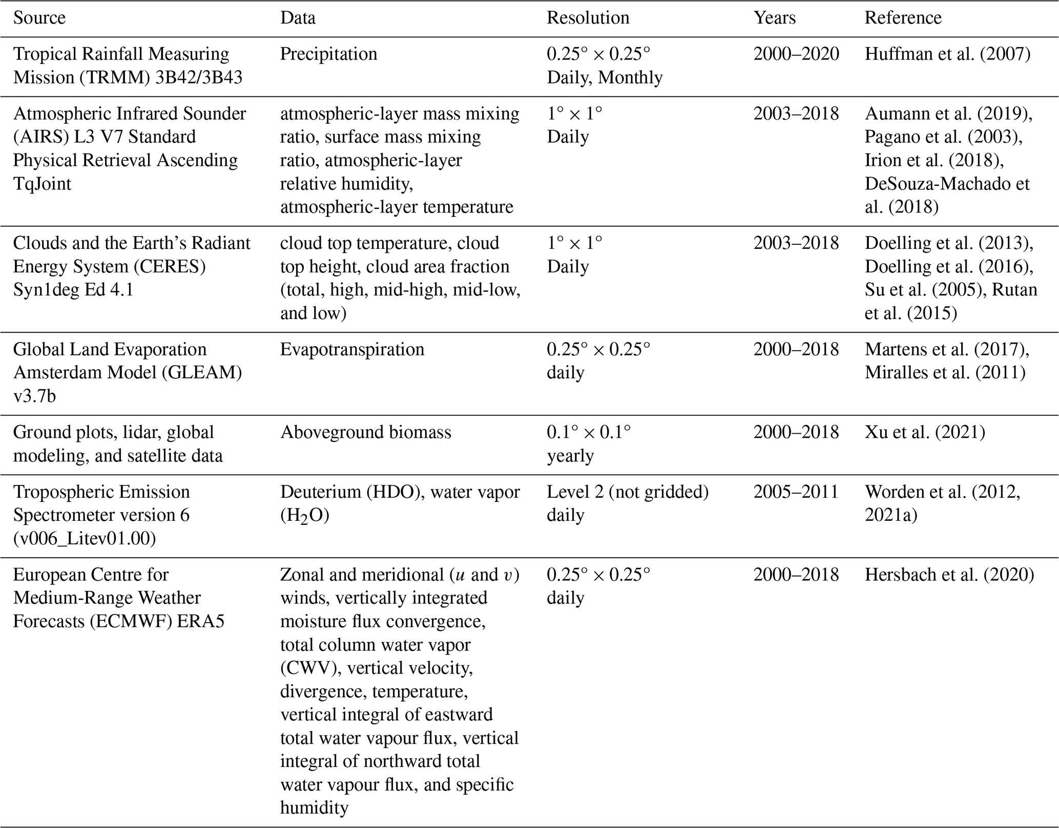
The TES data requires quality control processing described here: the following quality flags were used when retrieving the data from the TES satellite: “Species Retrieval Quality = 1”, “Degrees of Freedom for Signal >1”, and “Average Cloud Optical Depth <0.4” to ensure good quality data as suggested by Worden et al. (2012). The accuracy of these data is ∼6 ‰ (6 parts per thousand relative to the reference value) with a precision of 20 ‰ (Worden et al., 2012) for the vertical range used in this analysis (∼900–420 hPa, or about 1–6 km above sea level). We use data between 2005–2011 when the quality of estimates is suitable for our analysis (Worden et al., 2021b).
2.2 Methods
2.2.1 Calculating the Onsets and Ends of the Rainy Seasons
Using TRMM precipitation data, we calculate the rainy season onsets and ends (RSOs and RSEs, respectively) in the equatorial Congo Basin similar to the approach used in Chakraborty et al. (2021), originally developed by Li and Fu (2004), for RSOs and RSEs in the Amazon. This definition is designed to capture persistently high rainfall during the rainy season and persistent low rainfall in the dry season using the annual mean rainfall as the threshold. We first calculate the climatological pentad (5 d mean) rainfall for each year over our domain, then determine the RSOs and RSEs in the following steps.
For the spring rainy season, the onset is defined as the first pentad of each year that meets the following criterion: four out of the previous six pentads are less than the climatological annual mean, and four out of the following six pentads are more than the climatological annual mean. Likewise, the end of the spring rainy season is defined as the first pentad of each year that meets the following criterion: four out of the previous six pentads are more than the climatological annual mean, and four out of the following six pentads are less than the climatological annual mean.
For the fall rainy season, the onset is defined as the first pentad of each year that meets the following criterion: five out of the previous eight pentads are less than the climatological annual mean, and five out of the following eight pentads are more than the climatological annual mean. The fall RSE is defined as the first pentad of each year that meets the following criterion: six out of the previous eight pentads are more than the climatological annual mean, and six out of the following eight pentads are less than the climatological annual mean. We note that this criterion for the fall rainy seasons differs from that of the spring rainy season because the latter is shorter and weaker than that of the fall rainy season (Fig. 2). Therefore, a shorter period and less persistent threshold was needed to best capture the starts and ends of persistently high and low rainfall for the spring RSO and RSE.
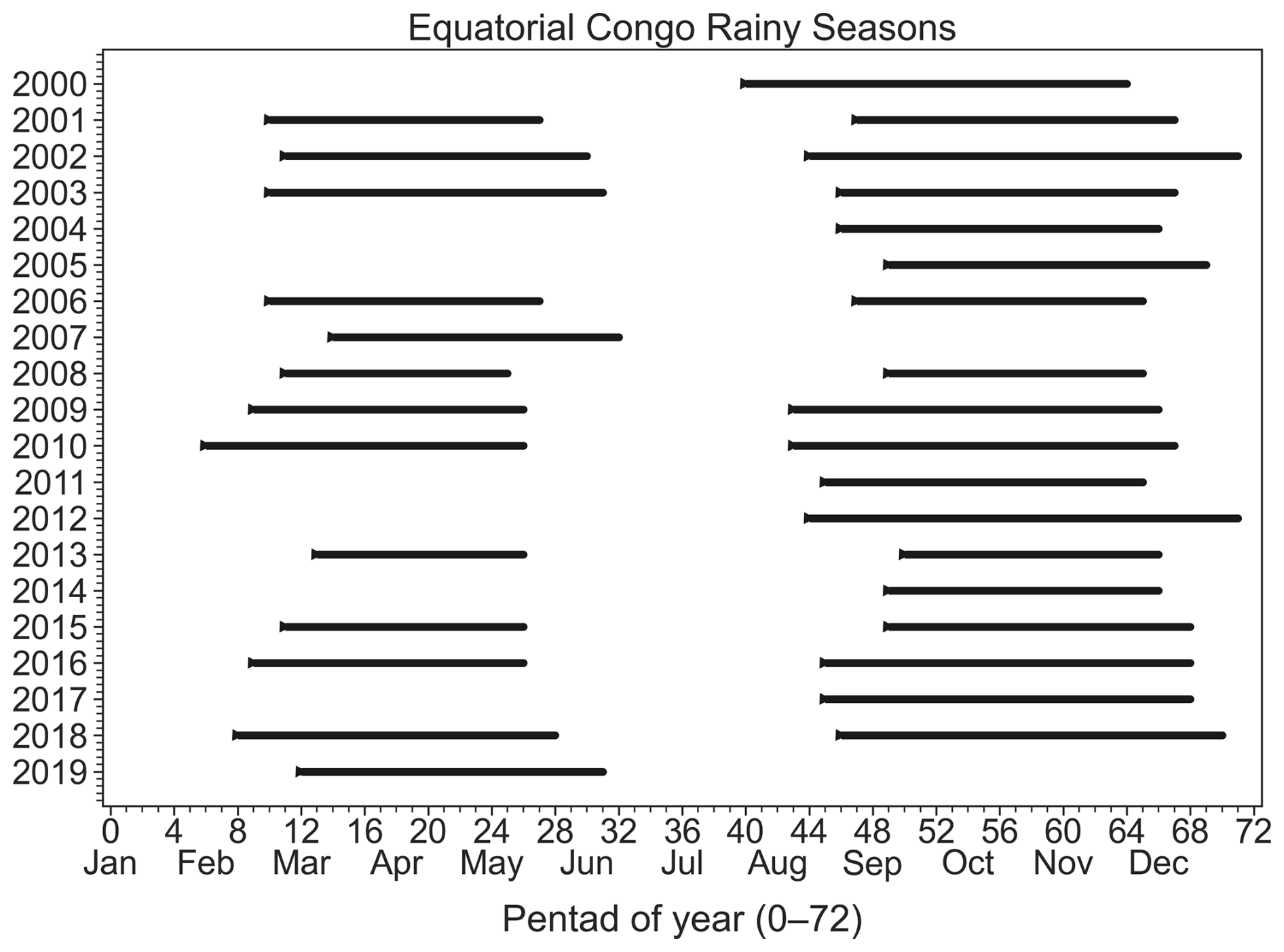
Figure 2Rainy season onset (RSO) and rainy season end (RSE) for the spring and fall rainy seasons for each year in the equatorial Congo.
Figure 2 shows the RSOs and RSEs for the spring and fall rainy seasons between the years 2000–2020. We excluded the year 2000 when calculating the spring RSO because we needed to consider the ends of the prior years in our RSO calculations. Similarly, we excluded the year 2020 when calculating the fall RSE because we needed to consider the start of the next years in our RSE calculations. We additionally excluded from our following analyses any years during which a RSO or RSE was unable to be identified, or if the length of a rainy season was less than 5 pentads. The spring RSO ranges from the 6th to 14th pentad (with Days 1–5 defined as Pentad “0”), corresponding to early-February to mid-March. On average, the spring RSO occurs on 20–24 February. The spring RSE ranges from the 25th–32nd pentads, corresponding to mid-May to mid-June. On average, the spring RSE occurs on 21–25 May. The fall RSO ranges from the 40th–50th pentads, corresponding to mid-July to early-September. On average, the fall RSO occurs on 18–23 August. The fall RSE ranges from the 64th–71st pentads, corresponding to mid-November to late-December. On average, the fall RSE occurs on 2–6 December. We show 15 pentads prior to the spring RSO and 19 pentads prior to the fall RSO as these periods capture the key changes in processes that drive the dry to rainy season transition as in Li and Fu (2004) and Wright et al. (2017).
2.2.2 Computation of Key Variables
We calculate the area-mean equivalent potential temperature (θe) from AIRS gridded data at daily time resolution to examine atmospheric instability during and after the transition to the rainy season. We calculate θe using the following equation from Bolton (1980):
Where Tk is the absolute temperature (K) at pressure level p, p is pressure (hPa), r is the mixing ratio (g kg−1), TL is the absolute temperature at the lifting condensation level (K) calculated by the following:
Where is the water vapor pressure, and here Tk0 is the absolute temperature at the surface, defined here as 925 hPa as the surface of the equatorial region is above sea level. We use the AIRS mass mixing ratio, temperature, and pressure in these calculations. We similarly calculate saturated equivalent potential temperature by letting r=rs, where rs is the saturated mixing ratio. We calculate rs by the following:
We calculate es as in Bolton (1980):
Where T is the temperature in Celsius (°C). We calculate saturated vapor pressure by:
Where ε=0.622 is ratio of molar masses of vapor and dry air, and es is the saturation vapor pressure, calculated as in Bolton (1980):
We also calculate moist static energy (MSE) where MSE is represented by:
Where cp is the specific heat capacity at constant pressure, L is the latent heat of evaporation and g is gravity.
Finally, we examine changes in moisture in the equatorial Congo with the following. We use vertically integrated moisture flux , where q is the specific humidity, and , is the horizontal wind, with u the zonal, and v the meridional wind components, respectively. Ps denotes the surface pressure and PTOA denotes the pressure of the top of the atmosphere. In particular, we calculate the net zonal and meridional MF as follows: We take the zonal vertically integrated across the western and eastern boundaries of the equatorial Congo basin, and the meridional vertically integrated across its northern and southern boundaries. For simplicity, we choose the northern boundary along 2° N and between 14–30° E, and the southern boundary along 2° S and between 14–30° E. The western boundary is along 14° E and between 2° S–2° N and the eastern boundary is along 30° E and between 2° S–2° N. To be able to compare to vertically integrated MF convergence, we calculate the length between the western/eastern boundaries and the northern/southern boundaries, respectively, and integrate average MFzonal and MFmeridional across these boundaries as in Satyamurty et al. (2013):
Where MFzonal, E is MFzonal integrated along the eastern boundary, MFzonal, W is MFzonal integrated along the western boundary, MFmeridional,N is MFmeridional integrated along the northern boundary, and MFmeridional,S is MFmeridional integrated along the southern boundary. y is the length of the northern/southern boundaries, and x is the length of the western/eastern boundaries. To calculate the net zonal vertically integrated MF, we calculate . To calculate the net meridional vertically integrated MF, we calculate . This ensures that positive values of Qzonal and Qmeridional means net convergence, and negative means net divergence.
We calculate the first component of the moisture flux convergence term (named the moisture convergence term, q⋅∇V) and moisture transport vectors (q⋅V) averaged between different pressure levels to represent the lower and middle tropospheric moisture transport. We do not examine the evolution of moisture advection term (V⋅∇q) as it is small compared to that of the moisture convergence term (Cook and Vizy, 2022; Figs. S1–S4 in the Supplement).
2.2.3 Examining the ET Contribution to Atmospheric Moisture
Due to a lack of reliable ET measurements, we use the deuterium content of water (HDO) derived from satellite measurements and an isotope mixing model to estimate the fractional contribution of ET to atmospheric moisture. HDO is expressed as the relative ratio of the number of HDO molecules to the total number of H2O molecules in parts per thousand (‰) relative to the isotopic composition of ocean water as shown below:
Where R is of the ratio of HDO molecules to the total number of H2O molecules and Rstd is the corresponding ratio in a reference standard, taken here to be the Vienna Standard Mean Ocean Water: (e.g. Wright et al., 2017, and references therein). The isotopic composition of water vapor in the free troposphere is due to a mixture of air parcels originating from different sources (Galewsky, 2018; Galewsky and Hurley, 2010). We can use the isotopic composition of an air mass to trace its source to either vegetation or ocean because δD values from ocean evaporation are distinctively different from those by rainforest ET. Atmospheric moisture coming from transpiration will generally be more isotopically enriched (or heavier) than evaporation because lighter isotopes preferentially evaporate (Risi et al., 2020; Tremoy et al., 2014; Worden et al., 2007). However, observed values of free-tropospheric deuterium content also depend on atmospheric processes, such as the type of convection present, described further in Galewsky et al. (2016). This is because they vary by the first order with changes in specific humidity (Bailey et al., 2017).
Therefore, we compare the observed isotopic composition of water vapor in the free troposphere to two models, a mixing model and a Rayleigh model, to identify which air parcels are likely influenced by land (i.e., transpiration) versus ocean (i.e., evaporated water; Noone, 2012). A mixing model describes what happens to a mixture of two air masses with different water vapor isotopic compositions. Meanwhile, under the Rayleigh distillation model, as an air mass moves upward (or towards cooler conditions), condensate enriched with heavy isotope is completely removed immediately after it forms under the assumption of pseudo adiabatic process (Galewsky et al., 2016; Wright et al., 2017). A further description of these models can be found in the Supplement and in Worden et al. (2021b).
2.2.4 Key Dynamic Features
We examine the seasonal evolution of key dynamic features that transport moisture and energy within and around the Congo Basin. They are discussed further in several review papers: Nicholson (2022), Pokam et al. (2026).
-
Low Level Westerlies (LLWs). These winds transport moisture from the Atlantic Ocean into Central Africa, with varying seasonal intensity (Pokam et al., 2012, 2014; Vondou et al., 2010)
-
Congo Basin Cell. The LLWs are the lower branch of both shallow and deep zonal circulations found over the Congo Basin. The shallow zonal circulation is called the Congo Basin Cell, with ascent over the Congo Air Boundary (see below), return at mid-levels via an easterly jet, and subsidence over the Atlantic Ocean (Longandjo and Rouault, 2020)
-
Shallow meridional overturning cell. Here, moisture moves meridionally from the Congo Basin to the Sahel heat low, with return leading to mid-tropospheric moisture convergence over the Congo Basin (Longandjo and Rouault, 2024)
-
African Easterly Jet North and South (AEJ-N, AEJ-S). The AEJ-N is a year-round feature with seasonal meridional migration from 5–17° N, while the AEJ-S is present between September–November with its core at ∼8° S (Nicholson and Grist, 2003; Kuete et al., 2020)
-
Congo Air Boundary. An extreme gradient in temperature and specific humidity that denotes the southern limit of Congo Basin, present between August to November (Howard and Washington, 2019).
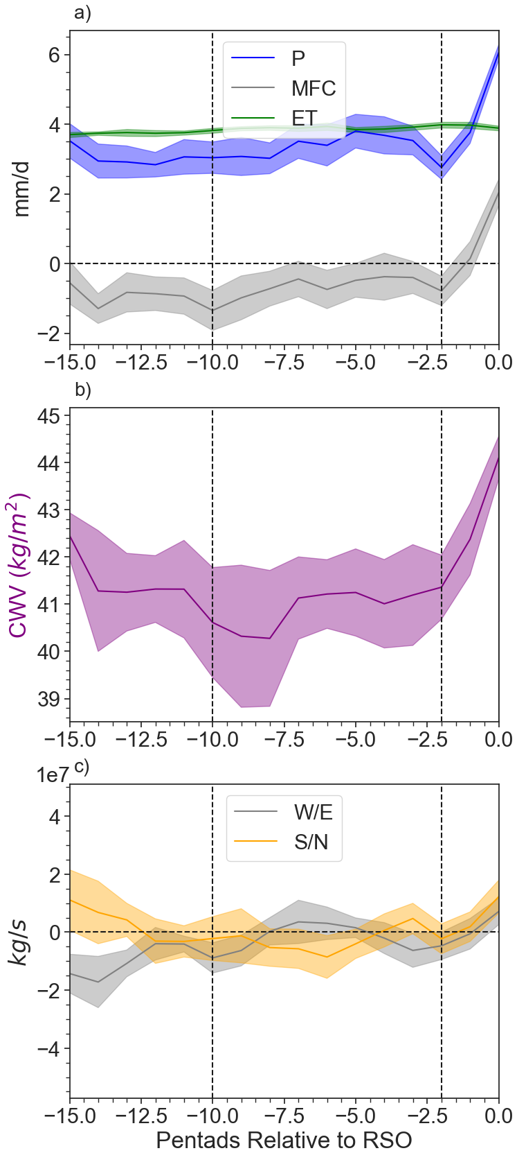
Figure 3For the transition to the spring RSO: (a) Precipitation (P), vertically integrated MF convergence (MFC), and evapotranspiration (ET); (b) column water vapor (CWV); and (c) Net vertically integrated MF across the zonal and meridional boundaries (Qzonal and Qmeridional; Methods, Units: 107× kg s−1). Positive means convergence, negative means divergence. All are relative to the RSO (denoted as “0” in the graph). Time series are smoothed using a Savitsky-Golay filter (number of coefficients: 5, polynomial order 2). Shades represent the standard error of the mean of the different years.
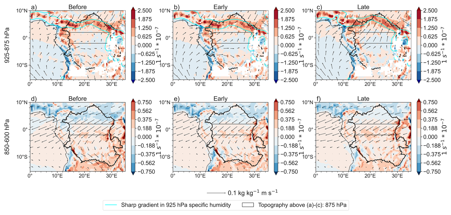
Figure 4Moisture transport vectors (q∗v) and moisture convergence term (q⋅DIV; shades, positive means convergence) for (a–c) average of 925–875 hPa for the “before” (15–11 pentads prior to the spring RSO). early, and late transition periods, respectively; (d–f) average of 850–600 hPa for the “before”, early, and late transition periods, respectively. Vectors are scaled up by a factor of 2 to better visualize the changes in magnitude and direction between periods. White masks in (a)–(c) represent areas where the elevation is higher than 875 hPa. Aqua contours in (a)–(c) represent sharp 925 hPa specific humidity gradients, which overlap with the area of convergence.
3.1 Transition from the Dry Season to the Spring RSO
3.1.1 Early Transition
The first part of the spring transition, i.e., the early-transition period, starts with a turning point from strengthening to weakening vertically integrated MF divergence (Fig. 3a) 10 pentads (50 d) before the spring RSO. To explain this weakening, we evaluate Qzonal and Qmeridional (Fig. 3c). Negative values indicate net moisture leaving the basin for both Qzonal and Qmeridional. Variations in Qzonal during the early transition period are driven by increases in low-level moisture transport from the Atlantic Ocean, by the lower branch of the Congo Basin Cell, which goes through the equatorial Congo, towards the West African Heat Low (Lavaysse et al., 2009) in the northern Congo (Figs. 4a, b; B1a, e). This is driven by increasing near-surface temperature gradients between the Atlantic Ocean and West African Heat Low (Figs. S5a, b; S6). These increases in low-level moisture transport, combined with increases in the second half of the transition period of mid-level moisture transport into the basin across its eastern boundary, acts against zonal moisture leaving the basin at mid-levels, across the western boundary (Fig. B1a, b), but is not enough to lead to Qzonal convergence (Fig. 3c). Meridionally, mid-level moisture entering the basin across the northern boundary does not change significantly, although low-level moisture leaving the basin across the northern boundary increases in response to increased low-level moisture transport towards the West African Heat Low (Figs. 4a, b; B1c, f). Across the southern boundary, moisture transport entering the basin at low levels increases, while moisture transport leaving the basin at mid-levels does not significantly change (Fig. B1d, f). Ultimately, it is changes in low-level meridional moisture transport that drive changes in Qmeridional divergence (Fig. 3c).
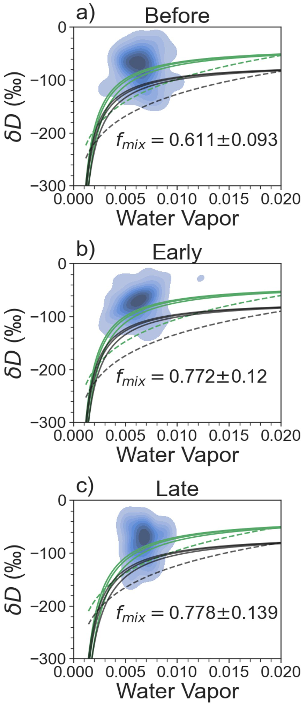
Figure 5Fraction of observed δD above a series of mixing (solid) and Rayleigh (dashed) models. Blue shades represent a density map of the TES δD observations. Green indicates land-based water vapor models, while black indicates ocean-based water vapor models. fmix is the fraction of observed δD above the uppermost, land-based mixing model. For (a) the “before” period (15–11 pentads prior to the spring RSO); (b) the early-transition; and (c) the late-transition.
Meanwhile, the contribution of ET to atmospheric moisture increases somewhat compared to the pre-transition (; ), and is clearly the dominant contributor to moisture (Fig. 5a, b). This is consistent with Worden et al. (2021b) for a similar domain. Therefore, ET is important for maintaining high background moisture while weakening in vertically integrated MF divergence initiates the transition to the spring RSO.
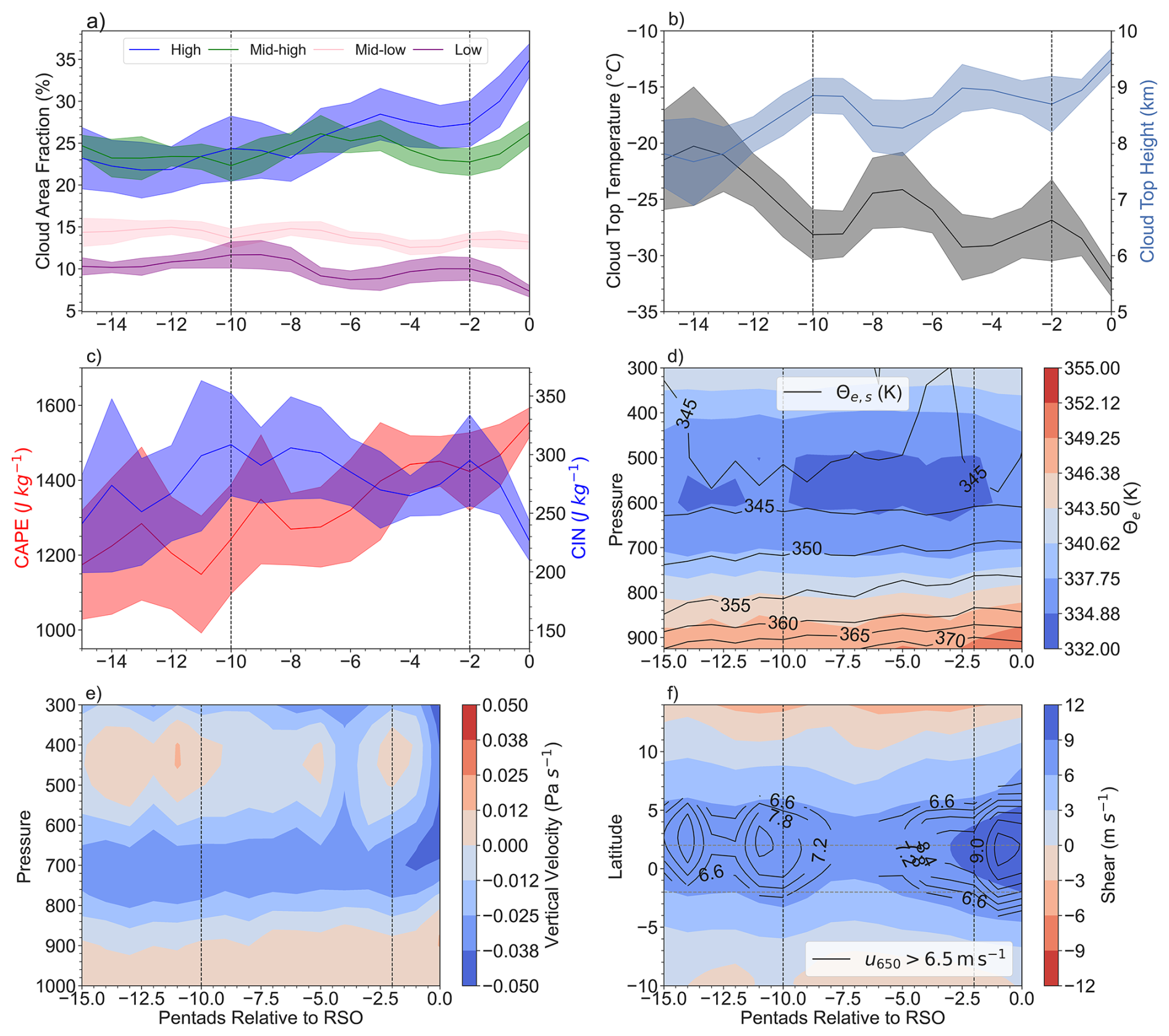
Figure 6Prior to the spring RSO: (a) cloud area fraction for high, mid-high, mid-low, and low clouds; (b) cloud top temperature and cloud top height; (c) CAPE; and CIN; (d) equivalent potential temperature (θe; shades) and saturated equivalent potential temperature (); (e) vertical velocity; and (f) black contours: 650 hPa zonal wind (u650) greater than 6.5 m s−1, denoting the AEJ-N. Shaded contours represent the wind shear (u900−u650). Shades of the time series in (a)–(c) represent the standard error of the mean of the different years. All the time series have been smoothed using a Savitsky-Golay filter (number of coefficients: 5, polynomial order 2).
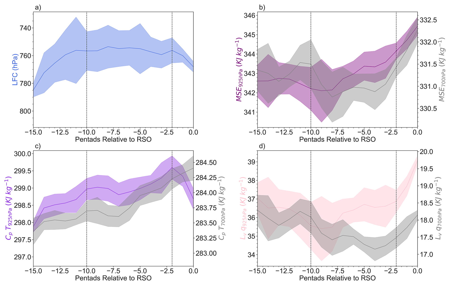
Figure 7Evolution of (a) the LFC; (b) MSE at 925 and 700 hPa; (c) MSE component CpT 925 and 700 hPa; and (d) MSE component Lvq at 925 and 700 hPa. All are relative to the spring RSO, averaged between 14–26° E to avoid topography errors in the calculations, and smoothed using the Savitsky-Golay filter. Shades represent the standard error of the mean of the different years.
Furthermore, the atmosphere appears thermodynamically primed for deep convection, with large convective available potential energy (CAPE) and conditional instability as shown by (Fig. 6c, d). However, weak ascent or even subsidence still exists above 650 hPa (Fig. 6e). Additionally, the level of free convection (LFC; Fig. 7a), and therefore convective inhibition energy (CIN, Fig. 6c) do not change significantly throughout the early transition period. This indicates that the atmospheric conditions, especially the dynamic conditions, are still not ready for large-scale increases of deep convection and subsequently, rainfall.
We explain this as following: with weakening atmospheric vertically integrated MF divergence, boundary layer specific humidity begins to increase (Fig. 7d), due to increases in moisture transport from the equatorial Atlantic Ocean into the equatorial Congo (Fig. 4a, b). The increase of boundary layer moisture, rather than increase of near-surface temperature, drives boundary layer increases in MSE (Fig. 7b–d). However, at the mid-levels, MSE initially decreases and then increases in mid-level specific humidity (Fig. 7b), which is driven by mid-level moisture divergence. Therefore, while the boundary layer MSE is favourable for deep convection, additional changes are needed to support deep convection in the mid-layers of the atmosphere.
3.1.2 Late Transition Period
The late-transition period starts with a rapid increase in atmospheric column water vapor (CWV; Fig. 3b), a key condition for deep convection (Bretherton et al., 2004; Schiro et al., 2018). This is accompanied by rapid increases in precipitation and vertically integrated MF convergence (Fig. 3a). ET does not change significantly (; Fig. 5c), revealing the importance of large-scale circulation changes in altering atmospheric moisture over the equatorial Congo prior to the spring rainy season.
Qzonal and Qmeridional rapidly switch from divergence towards convergence (Fig. 3c). Zonally, further increases in near surface temperatures over the West African Heat Low drive stronger LLWs from the Atlantic and across the equatorial region along the way (Figs. B1a, S5c, S6, 4c). This, together with increases in mid-level (above 800 hPa) zonal moisture transport across the eastern boundary (Fig. B1b) compensate the increases in mid-level moisture transport leaving the basin across the western boundary (Fig. B1a). The latter is likely due to the formation of the AEJ-N (Fig. 6f). Therefore, Qzonal becomes convergent, although weakly so (Fig. 3c). Meridionally, moisture transport entering the basin at low levels through the southern boundary increases (Fig. B1c), bringing with it moist air from the southern Congo (Fig. S7c), which is experiencing its rainy season during this time (Worden and Fu, 2025). However, moisture transport leaving the basin across its northern boundary towards the West African Heat Low increases as well (Fig. B1d), leading to net low level meridional moisture transport out of the basin (Fig. 4c). In contrast, moisture convergence at mid-levels increases (Fig. 4f) as mid-level moisture leaving the basin across the southern boundary decreases (Fig. B1d, f). Altogether, this leads to Qmeridional convergence (Fig. 3c).
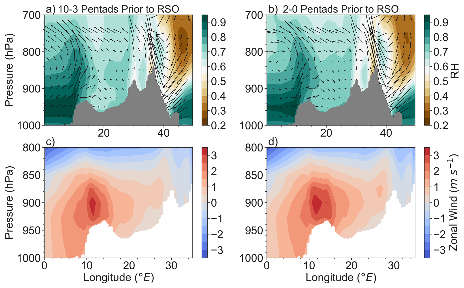
Figure 8Relative humidity (shades) and vectors of u and ω×102 for (a) 10–3 pentads prior to the spring RSO; (b) 2–0 pentads prior to the spring RSO. Zonal wind (u) for (c) 10–3 pentads prior to the spring RSO; (d) 2–0 pentads prior to the spring RSO. Grey shading in (a)–(b) and white shading in (c)–(d) denotes the topography of the region.
These changes in atmospheric moisture transport increase boundary layer moisture, as indicated by increasing relative humidity (Fig. 8a, b), but subsidence from the surface to ∼850 hPa (Figs. 6e, 8a, b) between 10–26° E (west of the East African Rift) likely prevents this moisture from being uplifted within large parts of the interior equatorial region. Instead increases in westerly wind within the interior of the region pushes this moisture towards the East African Rift (Fig. 8), where orographic lifting forces this moist air into the free troposphere above 800 hPa. Additionally, moisture is uplifted by the ascending branch of the Congo Basin Cell over the equatorial coastline (highlands of Gabon and Cameroon) at the western edge of the equatorial Congo (Fig. 8). Therefore, this results in increasing mid-level moisture and mid-level MSE while decreasing LFC and CIN (Figs. 6c, 7a, b, d). Upward vertical velocity increases in strength starting in the mid-levels and reaches 300 hPa for the first time (Fig. 6e). Meanwhile, shear increases with the increasing strength of the AEJ-N (Fig. 6f), thus creating conditions favourable for deep convection and the start of the spring rainy season. This is indicated by increases in high clouds, increases in cloud top height, and decreases in cloud top temperature (Fig. 6a, b).
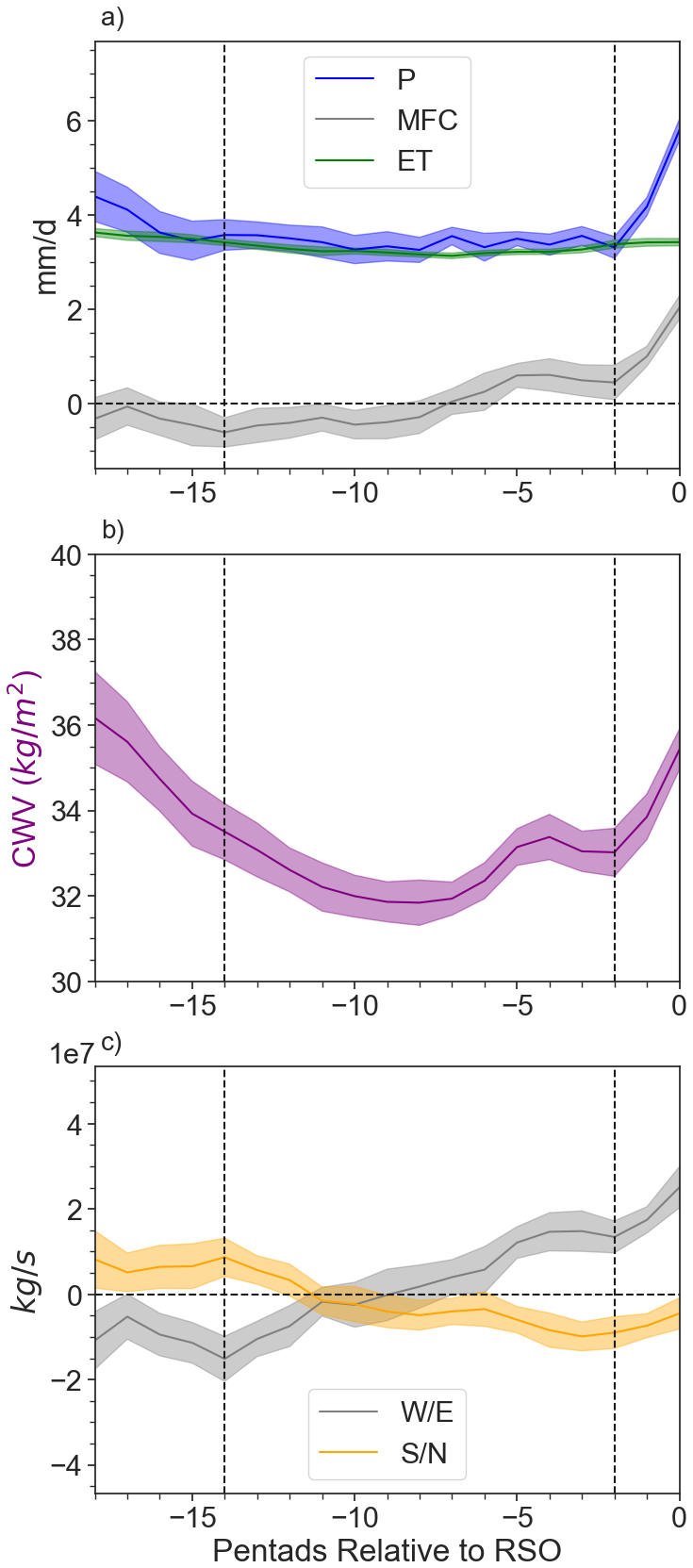
Figure 9For the transition to the fall RSO: (a) Precipitation (P), vertically integrated MF convergence (MFC), and evapotranspiration (ET); (b) column water vapor (CWV); (c) Qzonal and Qmeridional (Methods; Units: 107× kg s−1). Positive means convergence, negative means divergence. All are relative to the RSO (denoted as “0” in the graph). All have been smoothed using a Savitsky-Golay filter (number of coefficients: 5, polynomial order 2). Shades represent the standard error of the mean of the different years.
3.2 Transition from the Dry Season to the Fall RSO
3.2.1 Early Transition Period
As in the transition to the spring RSO, the early-transition period starts 14 pentads before the fall RSO with weakening in vertically integrated MF divergence over the equatorial Congo (Fig. 9a), indicated reduced moisture export out of the region. This is mainly due to decreases in Qzonal divergence (Fig. 9c), which becomes convergent about halfway through the early transition period. This acts against the change of Qmeridional, which starts convergent and switches to divergence during the transition period (Fig. 9c).
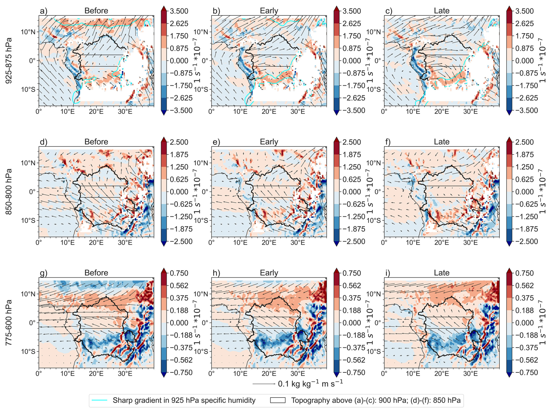
Figure 10Moisture transport vectors (q⋅v) and moisture convergence (q⋅DIV; shades, positive means convergence) for (a–c) average of 925–875 hPa. The westerly winds represent the lower branch inflow of the Congo Basin Cell; the aqua shades denote areas of sharp 925 hPa specific humidity gradients. The southern aqua gradients therefore note the rough location of the Congo Air Boundary. (d–f) average of 850–800 hPa; and (g–i) average of 775–600 hPa. The easterly winds represent the upper branch return flow of the Congo Basin Cell. Vectors have been multiplied by a scale factor of 2 in all panels. Area of convergence between 4 and 8° S in (a)–(c) represents the rough location of the Congo Air Boundary (CAB). Mainly zonal moisture transport between 6–15° N represents the AEJ-N.
Changes in initial Qzonal divergence are primarily due to increases in low-level moisture transport into the basin, across the western boundary (Figs. 10a, b; B2a), which combined with steady moisture transport between 800–600 hPa into the basin across the eastern boundary (Fig. B2b), acts against weakly decreasing moisture transport out of the western boundary above 800 hPa (Fig. B2a) via the return branch of the Congo Basin Cell (Longandjo and Rouault, 2020). Increases in low-level atmospheric moisture across the western boundary are driven by the near-surface temperature gradient between the Atlantic Ocean and the equatorial and southern Congo (Figs. S8a, b; S9), which strengthens the lower branch of the Congo Basin Cell (Longandjo and Rouault, 2020).
Qmeridional convergence initially weakens towards zero (Fig. 9c). Across the southern boundary, moisture transport leaving the basin at low levels increases (Fig. B2d, f), moving towards the Congo Air Boundary (aqua contours in Fig. 10b denote sharp surface humidity gradients that show the rough location of the Congo Air Boundary; Howard and Washington, 2019) and associated low-level convergence band (Fig. 10b). Additionally, moisture transport into the equatorial Congo across the southern boundary, above 850 hPa, decreases in strength (Fig. 10d, e). This acts against increases in low-level moisture entering the basin across the northern boundary (Fig. B2d). Together, this causes the Qmeridional divergence by the end of the transition period.
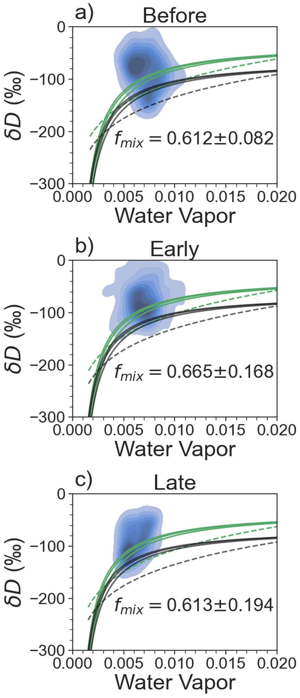
Figure 11Fraction of observed δD above a series of mixing (solid) and Rayleigh (dashed) models. Blue shades represent a density map of the TES δD observations. Green indicates land-based water vapor models, while black indicates ocean-based water vapor models. fmix is the fraction of observed δD above the uppermost, land-based mixing model. For (a) the “before” period (19–14 pentads prior to the fall RSO); (b) the early-transition; and (c) the late-transition.
Meanwhile, the contribution of ET to atmospheric moisture does not change significantly: during the “before” period, while during the early transition (Fig. 11a, b). Therefore, it is the increases of low-level moisture from the Atlantic Ocean that initiate the early transition period prior to the fall RSO.
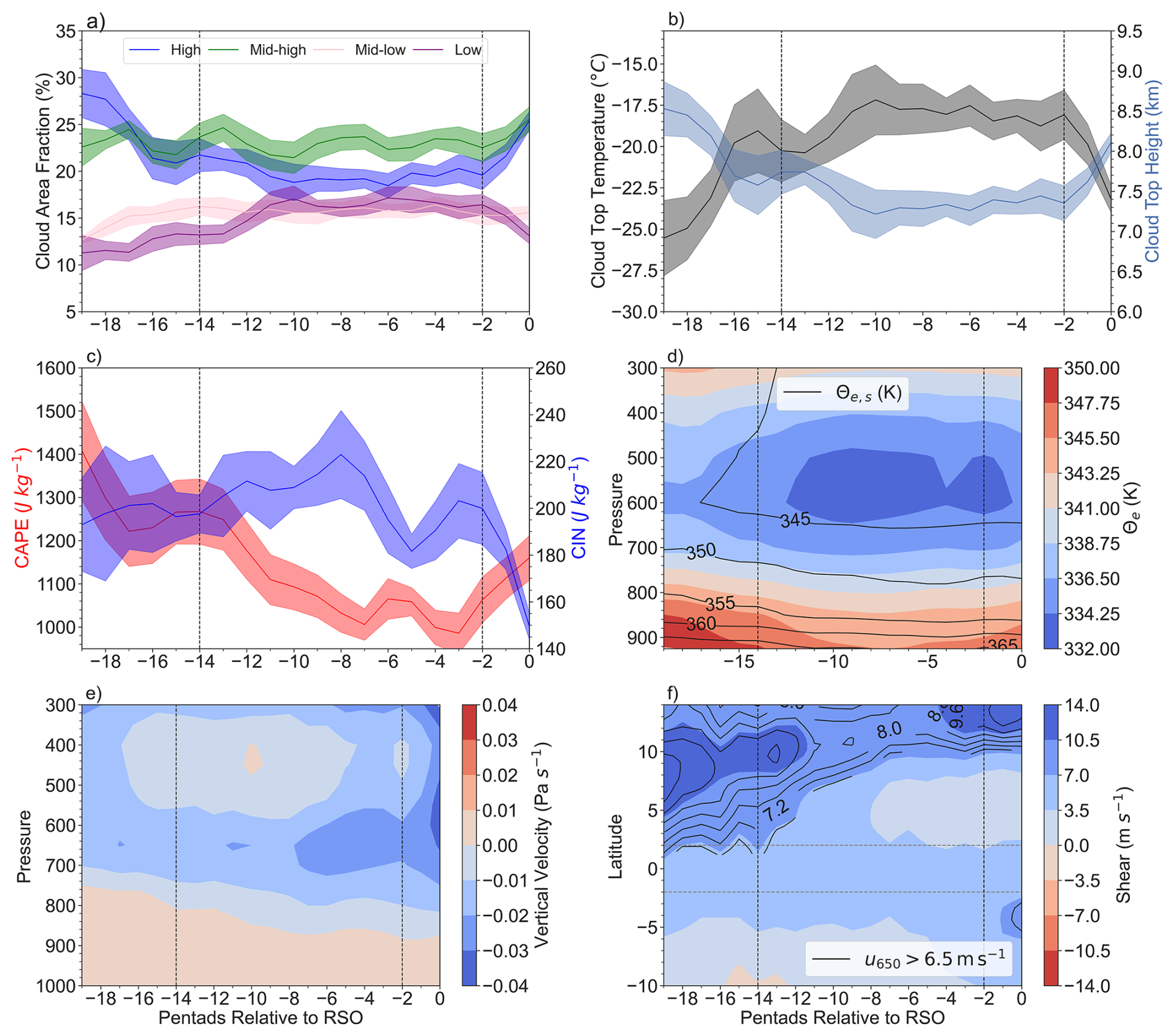
Figure 12Prior to the fall RSO: (a) cloud area fraction for high, mid-high, mid-low, and low clouds; (b) cloud top temperature and cloud top height; (c) CAPE and CIN; (d) equivalent potential temperature (θe; shades) and saturated equivalent potential temperature (); (e) vertical velocity; and (f) black contours: 650 hPa zonal wind greater than 6.5 m s−1, denoting the AEJ-N. Shaded contours represent the wind shear (u900−u650). Shades of the time series in (a)–(c) represent the standard error of the mean of the different years. All the time series have been smoothed using a Savitsky-Golay filter (number of coefficients: 5, polynomial order 2).
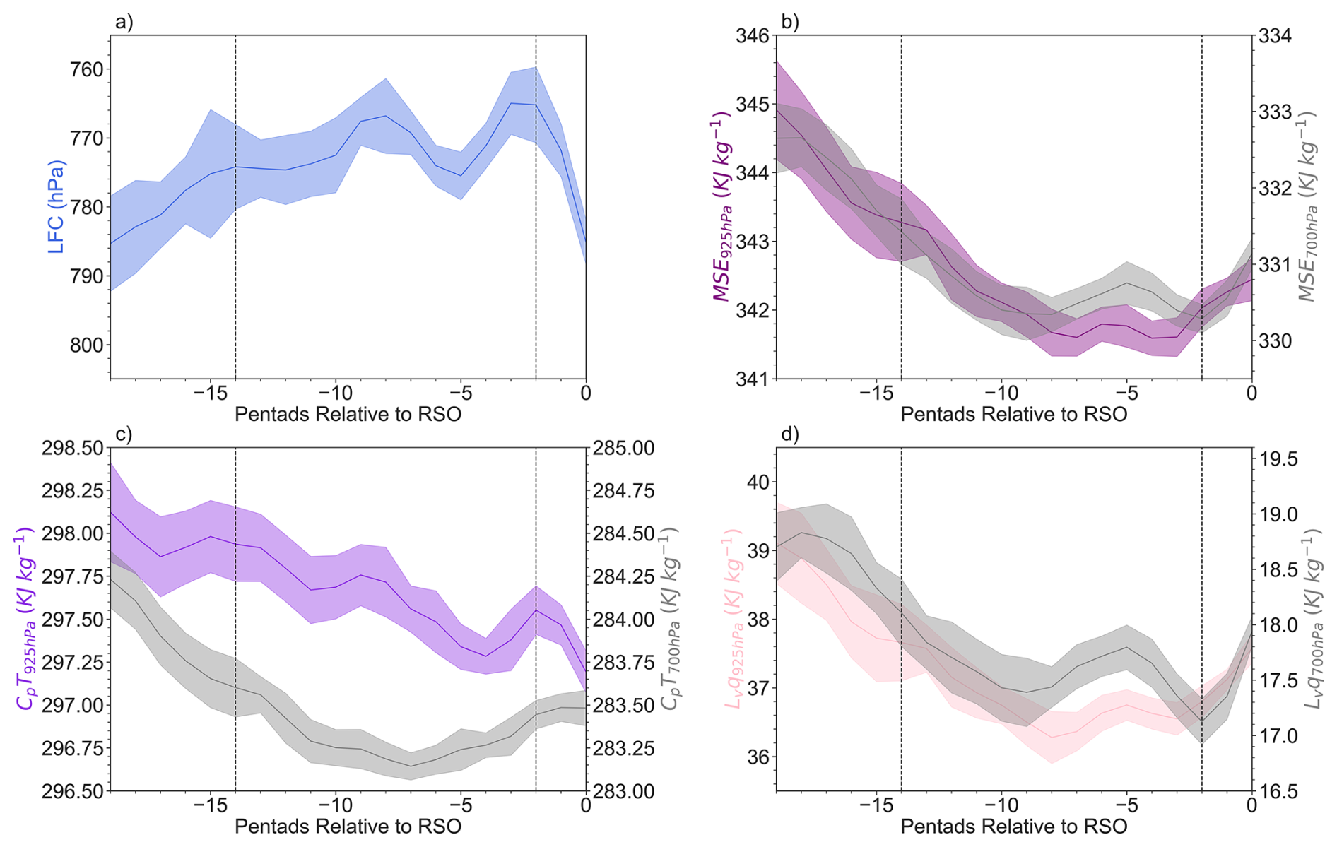
Figure 13Evolution of (a) LFC, (b) MSE at 925 and 700 hPa; (c) CpT at 925 and 700 hPa; and (d) Lvq at 925 and 700 hPa. All are prior to the fall rainy season. All are averaged between 14–26° E to account for effects of topography in the eastern part of the region. All have been smoothed using a Savitsky-Golay filter. Shades represents the standard error of the mean of the different years.
Despite an overall unstable lapse rate (), the thermodynamic condition of tropospheric column does not yet support deep convection. In the first half of the early transition, decreases in low-level atmospheric moisture (Fig. 13d) weakens negative , coinciding with rising CIN and LFC, as well as decreasing CAPE and low and mid-level MSE (Figs. 12c, d; 13b, c). Changes in MSE at both levels are mainly due to changes in Lvq rather than CpT (Fig. 13b, c, d). In the second half of the early transition, low-level moisture begins to increase, corresponding to increases in θe in the low-levels and strengthening negative (destabilizing) (Figs. 12c, 13d). This corresponds to the LFC stabilizing (no longer consistently increasing) between −7 to −2 pentads prior to the RSO (Fig. 13a) and decreases in CIN (Fig. 12c). Additionally, the vertical velocity is near zero above 600 hPa (Fig. 12e). Therefore, atmospheric dynamic conditions are not yet ready to facilitate increase of deep convection, consistent with relatively low and constant mid-high and high cloud covers (Fig. 12a), cloud top temperatures, and cloud top heights (Fig. 12b).
3.2.2 Late Transition Period
The late transition period to the fall rainy season starts with sharp increases in precipitation, vertically integrated MF convergence, and CWV (Fig. 9a, b). Meanwhile, the contribution of ET to atmospheric moisture () does not change significantly (Fig. 11c). Qzonal convergence sharply increases, while Qmeridional divergence weakens to near zero (Fig. 9c).
Zonally, the speed of low-level westerly wind that carry moisture from the Atlantic Ocean further increases (Fig. 10b, c). This is due to further increases in the zonal temperature gradient as the Atlantic cold tongue develops (Figs. S8b, c; S9; Caniaux et al., 2011), which increases the strength of the lower branch of the Congo Basin Cell (Longandjo and Rouault, 2020). Meanwhile, the strength of the mid-level zonal moisture transport does not change as much compared to its low-level counterpart, indicating that the sharp increase in Qzonal convergence is driven by increases low-level moisture transport (Figs. 9c; B2a, b, e).
Meridionally, in the low-levels, moisture transport out of the southern boundary into the southern Congo continues to increase as the low-level winds move towards the Congo Air Boundary (Fig. 10b, c). However, this is compensated by moisture transport into the equatorial Congo across the southern boundary above 850 hPa (Figs. 10e, f, h, g; B2d). Across the northern boundary, low level moisture transported into the basin increases, acting against mid level moisture leaving the basin (Fig. B2c). Therefore, Qmeridional divergence decreases (Fig. 9c).
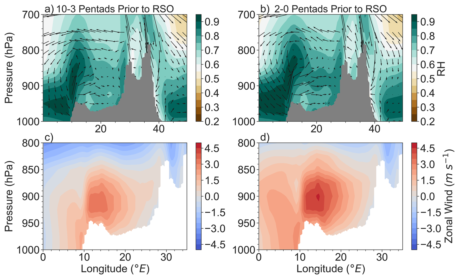
Figure 14The zonal and vertical cross-section of relative humidity (shades) and vectors of u and ω averaged between 2° S–2° N for (a) the early transition period, i.e., 14–3 pentads prior to the fall RSO; (b) the late transition period, i.e., 2–0 pentads prior to the fall RSO. The vertical wind, ω, is magnified by multiple 100. As in (a)–(b), but for zonal wind speed (u) for (c) 14–3 pentads prior to the fall RSO; and (d) 2–0 pentads prior to the fall RSO. Grey mask in (a)–(b) and white mask in (c)–(d) denote the topography of the region.
At the low-levels, atmospheric moisture increases rapidly due to increases in westerly winds (Fig. 14) and further destabilizes (strengthens negative ; Fig. 12d). The increased atmospheric moisture lifts up into the mid-troposphere above 800 hPa via the ascending branch of the Congo Basin Cell (located between 10–20° E) as well as orographically along the slope of the East African Rift (Fig. 14a, b), Therefore, mid-tropospheric relative humidity increases (Fig. 14b) despite subsidence in the low troposphere in the interior of the basin (Figs. 12e; 14b). As the mid-troposphere moistens, the thermodynamic atmospheric condition becomes favourable for deep convection rapidly, as shown by decreases in CIN (Fig. 12c) and LFC (Fig. 13a), and increases in CAPE (Fig. 12c).
Meanwhile, despite the absence of the AEJ-N or AEJ-S over the equatorial region (Fig. 12f), the return branch of the Congo Basin Cell provides the vertical wind shear (Fig. 12f, on average within the equatorial region 8.30 m s−1 during the late transition period prior to the fall RSO compared to 8.55 m s−1 during the late transition period prior to the spring RSO) needed for favourable dynamic conditions for mesoscale convective systems (MCSs). These conditions enable rapid increase of P (Fig. 9a), and lead to the fall RSO as indicated by increases in the strength of vertical velocity from the lower atmosphere to 300 hPa (Fig. 12e), sharp increases (decreases) in high/mid-high (low) clouds, sharp increases in cloud top height, and sharp decreases in cloud top temperatures (Fig. 12a, b).
In summary, the transition from the boreal summer dry season to the fall RSO is mainly initiated by increasing westerly moisture transport from Atlantic Ocean into the equatorial Congo basin in the boundary layer via the lower branch of the Congo Basin Cell (925–875 hPa). These changes start 14 pentads (around mid-June) before the fall RSO (around late August). This weakens the vertically integrated MF divergence, which, in turn, slows down the drying trend during the dry season. Low-level moisture increases due to increases in moisture transport from the Atlantic Ocean during the early transition (14–3 pentads before the fall RSO). Mid-level atmospheric moisture increases as a result of increased uplift via the ascending branch of the Congo Basin Cell and orographic uplift against the East African Rift during the late transition period. This increases CWV, which subsequently reduces CIN and lows the LFC, while increasing CAPE, MSE and vertical wind shear. Subsequently, the fall rainy season begins.
4.1 Comparing the Transition to the Spring vs. Fall Rainy Seasons
Here, we compare how conditions evolve to trigger the spring and fall rainy seasons, clarifying the similarities and differences in the controlling processes and their interactions that lead to each season's onset.
Prior to the spring rainy season, low-level moisture from the equatorial region is transported to the West African Heat Low, mixes with warm air from the Sahelian region (Figs. 4c; S5), uplifts, and then returns to the equatorial Congo (Fig. 4f) at the mid-levels (850–600 hPa). Therefore, a shallow meridional overturning cell exists that moves moisture northward at low levels, and southward at mid-levels. In contrast, prior to the fall rainy season, low-level moisture from the Atlantic Ocean turns towards the Congo Air Boundary located in the southern Congo. This low-level moisture transport into the equatorial Congo across the western boundary is greater in the fall rainy season compared to the spring rainy season, consistent with Pokam et al. (2012) who found that the Atlantic Ocean plays an important role in low-level moisture flux between August–November. As this low-level moisture reaches the Congo Air Boundary, it mixes with warm air from the southern Congo Basin (Fig. S8e, f) and South Africa (Worden and Fu, 2025), uplifts, and then returns to the equatorial Congo (Fig. 10d–i). Therefore, a shallow meridional overturning cell exists that moves moisture southward at low levels, and northward at mid-levels.
Furthermore, the Congo Basin Cell moves further into the interior of the basin prior to the fall RSO compared to the spring RSO, with its ascending branch located around 20° E prior to the fall and located around 15° E prior to the spring rainy season (Figs. 8a, b; 14a, b). Therefore, less moisture is brought into the region across its western boundary prior to the spring (Figs. B1a; B2a) and prior to the fall. Finally, the cause of the lower to middle tropospheric wind shear differs between the two rainy seasons. The zonal shear increases prior to the start of the rainy season is induced by the formation of the AEJ-N, present in the equatorial region. Meanwhile, prior to the fall rainy season, shear exists due to the return branch of the Congo Basin Cell, at similar pressure levels, but it is weaker compared to the wind shear prior to the spring RSO.
Additionally, the thermodynamic conditions are more favourable for convection prior to the fall RSO than the spring RSO. CIN prior to the spring rainy season ranges from 226–308 J Kg−1 and is 226 J kg−1 1 pentad prior to RSO, while CIN prior to the fall rainy season ranges from 149–222 J kg−1 and is at 149 J kg−1 1 pentad prior to the RSO. The LFC is also higher by the beginning of the spring RSO compared to the fall RSO. Therefore, the cloud base is higher, and convective air must overcome stronger CIN prior to the spring RSO.
Finally, both transition periods show increasing low-level atmospheric moisture before increases in mid-level atmosphere, and the moistening of the mid-level during late transition seasons that is important for increasing deep convection and initiating both RSOs. The increase of low-level zonal moisture transport is mainly responsible for increasing the lower-level moisture, whereas the increase of mid-level is main due to lifting of the low-level moisture to the mid-level by ascending branch of the Congo Basin Cell over the western equatorial Congo basin and by the East African rift over the eastern equatorial Congo basin.
4.2 Comparing the Transition to the Fall Rainy Season in the Equatorial vs. Southern Congo
We next compare the transition period to the fall rainy season in the equatorial versus southern Congo. The fall RSO is earlier over the equatorial Congo basin, beginning on average 18 August, than that over the southern Congo, beginning on average 9 October (Worden and Fu, 2025). This difference in timing is likely driven, in part, by the seasonal movement of the Congo Air Boundary (Longandjo and Rouault, 2020), which is centred closer to the equator prior to the equatorial fall RSO (Fig. 10b, c) and then moves towards the southern Congo prior to its fall RSO (Worden and Fu, 2025). This southward movement brings with it moisture from the equatorial region, supporting the southern Congo RSO in boreal fall. Furthermore, moisture contributions between the two regions differ greatly. ET is the dominant contributor to atmospheric moisture prior to the fall rainy season in the equator; however, it does not change significantly during the transition period. Meanwhile, for the southern region, ET increases significantly and contributes equally to atmospheric moisture as the oceanic moisture transport by the late transition period. Therefore, the increases of moisture prior to the RSOs in the equatorial region are primarily controlled by advected oceanic moisture, while over the southern Congo, moisture increases are controlled by increases of both moisture transport from the ocean and from ET over land.
Additionally, atmospheric instability differs strongly. In the equatorial region, CAPE is much higher than CIN for the entire transition period, helping initiate a large jump in precipitation once CIN decreases as there is plenty of energy for deep convection. However, in the southern region, CAPE is lower, and CIN is higher than in the equatorial Congo, where above 700 hPa is dominated by adiabatic warming due to subsidence until the late transition period. Therefore, the equatorial region has larger potential for storms and heavy rain to occur than in the southern Congo basin.
Finally, the AEJs play different roles between the equatorial region and the southern Congo. In the equatorial region, both the AEJ-S and AEJ-N do not play a direct role in determining vertical wind shear prior to the fall RSO. In contrast, the AEJ-S directly contributes to the vertical wind shear prior to the RSO in the southern Congo. Therefore, it is important to consider the sub-basin scale variability in the evolution of atmospheric conditions prior to the transition to the RSOs that will likely react differently to climate perturbations and hence the seasonal rainfall cycle.
Using a suite of satellite and reanalysis data, we examined the mechanisms controlling the transition periods to the spring and fall rainy season in the equatorial Congo. We summarize these mechanisms below (Fig. 15).
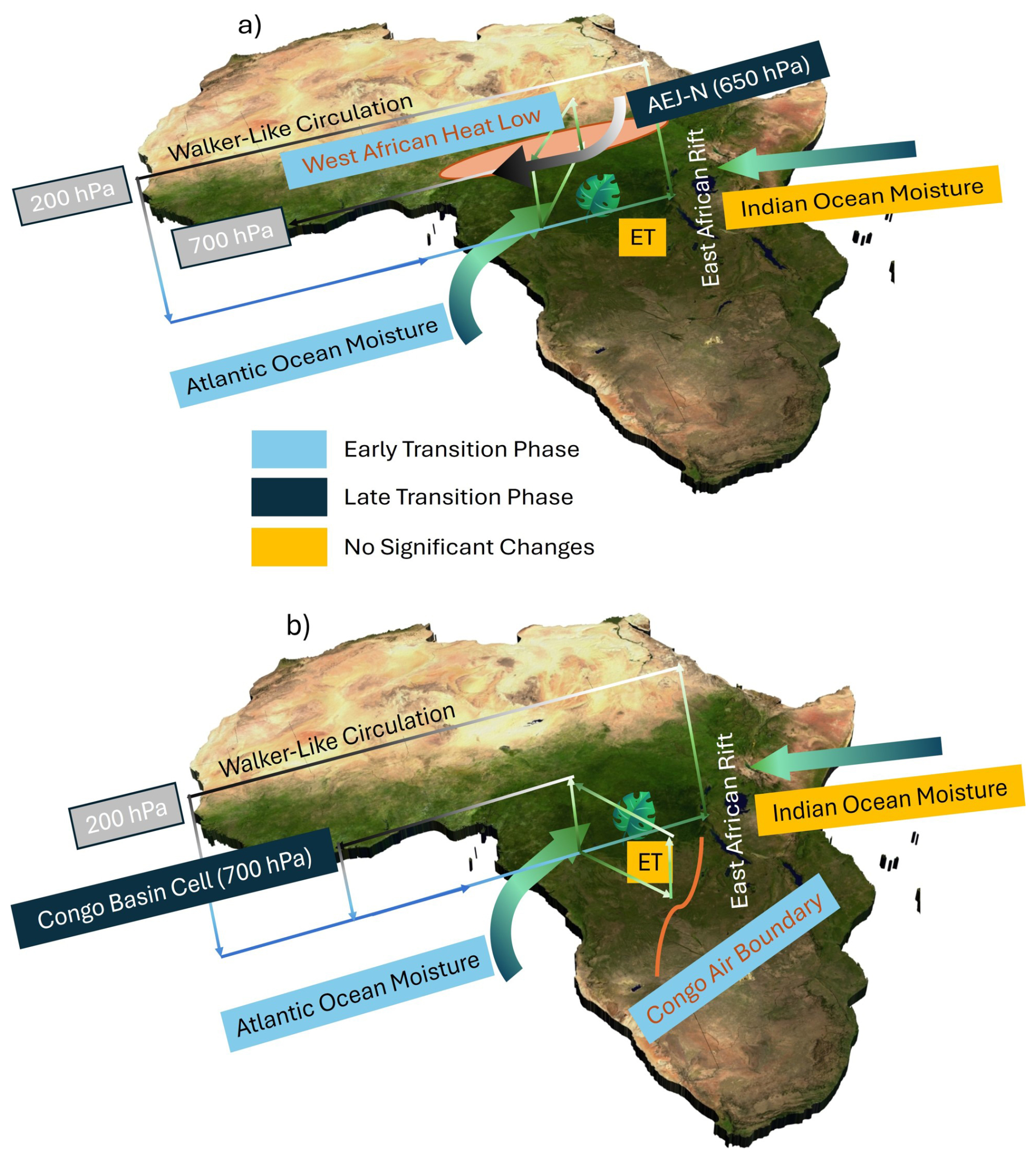
Figure 15Summary of the key systems controlling moisture transport over the equatorial Congo Basin prior to (a) the spring RSO and (b) the fall RSO.
Spring rainy season onset
-
Early-transition. This period starts with a turning point from strengthening to weakening of the vertically integrated MF divergence. Changes in both Qzonal and Qmeridional lead to near zero vertically integrated MF divergence by the end of this period. This is due to (1) increases in low-level moisture entering the basin from the Atlantic Ocean; and (2) initial decreases and then increases in mid-level moisture entering the basin from the Indian Ocean and leaving the basin back towards the Atlantic Ocean. Changes in Qmeridional are due to increases in low-level moisture leaving the basin across the northern boundary towards the West African heat low level moisture entering the basin across the southern boundary. ET contributes the most to atmospheric moisture but does not change significantly. Meanwhile, large CAPE, and negative , but large CIN and high LFC, as well as the presence of subsidence in the upper troposphere, indicates that thermodynamic conditions are beginning to change in favour of deep convection.
-
Late-transition. This period starts with sharp increases in CWV, indicating atmospheric moistening, vertically integrated MF convergence, and precipitation. Increases in low-level moisture transport into the region from the Atlantic Ocean and mid-level transport into the region from the Indian Ocean act against moisture leaving the region at mid-levels back towards the Atlantic Ocean. Low-level moisture is lifted to the mid-troposphere by the ascending branch of the Congo Basin Cell on the western edge of the region, and by orographic uplift in the eastern part of the region as moisture is pushed up the East African Rift. Meridionally, more moisture transport enters the region across the northern boundary than leaves the basin across the southern boundary, supporting mid-level MF convergence (most important feature for predicting precipitation; Table 2). Atmospheric moisture increases, causing decreases in CIN (second-most important feature for predicting precipitation; Table 2) and lowering of the LFC. Additionally, the AEJ-N moves over the equatorial region, providing vertical wind shear. This all leads to sharp increases in precipitation. That ET contribution to atmospheric moisture does not change significantly indicates that it provides background moisture but does not contribute to transitioning the atmospheric conditions to be conducive for deep convection.
Table 2Summary of changes to key features controlling the rainy season transition periods for the spring and fall rainy seasons. A ridge regression was performed to show which features are most important to controlling P during the transition period. We used daily data, choosing the average number of days in between the previous RSE and respective RSO (75 d between the fall RSE to spring RSO, 95 d between the spring RSE-fall RSO). We standardized the features by removing the mean and scaling to unit variance. The R2 represents the performance of the test dataset (30 % of data withheld when training the model).
Fall rainy season onset
-
Early Transition. This period starts from a turning point from increasing to weakening vertically integrated MF divergence, which reaches convergence about halfway through the period. These changes are primarily due to large increases in Qzonal convergence, as increases in low-level moisture transport from the Atlantic Ocean, due to the strengthening of the lower-branch of the Congo Basin Cell (Longandjo and Rouault, 2020), act against mid-level moisture transport out of the region back towards the Atlantic Ocean. Therefore, low-level moisture increases in the second half of the transition period, increasing CWV and strengthening the negative gradient. However, as mid-level atmospheric moisture decreases to a minimum, atmospheric thermodynamic conditions are not yet ready to support deep convection, as CIN is high and the LFC is elevated.
-
Late Transition. CWV, vertically integrated MF convergence, and precipitation increase sharply. ET remains the same, but it contributes an equal amount of atmospheric moisture for rainfall as in the early transition period. Qzonal convergence increases as low-level moisture from the Atlantic Ocean increases. Qmeridional divergence goes to near zero despite increases in low-level moisture transport towards the Congo Air Boundary across the southern boundary. Low-level moisture is pushed upwards by the ascending branch of the Congo Basin Cell, located more centrally in the region compared to prior to the spring RSO, as well as up against the East African Rift. This, along with increases in mid-level meridional MF convergence (moisture transport entering the basin is greater than moisture transport leaving the basin above 850 hPa) supports mid-level MF convergence (most important feature for predicting precipitation; Table 2) and moistens the mid-troposphere, lowering CIN and the LFC. The westerly return branch of the Congo Basin Cell provides the vertical shear needed. Therefore, conditions are conducive for the start of the rainy season.
The clarification of the atmospheric processes that drive the dry to rainy season transition provided by this study will lay the groundwork for understanding variability in the seasonal cycle of precipitation. This includes changes induced by ENSO, the Indian Ocean Dipole, and Madden-Julian Oscillations (e.g., Kebacho and Sarfo, 2023; Moihamette et al., 2022; Jury et al., 2009; Creese et al., 2019), variability induced by aerosols (Chakraborty et al., 2020), by the poleward movement of the northern and southern heat lows (Cook et al., 2020), and by the long-term AMJ drought (Jiang et al., 2019). Overall, the equatorial region seasonal rainfall is influenced by a combination of local (e.g., ET providing background moisture, and orographic uplift) and regional factors (e.g., moisture from the Atlantic Ocean, the West African Heat Low, and the Congo Air Boundary). Therefore, it is important to consider the influence of climate variability on the rainy season timing and intensity on both scales.
The following text further explains the comparison of the observed δD measurements to the mixing and Rayleigh models, as well as the error calculations involved:
A mixing model is described as follows:
Where q0 and δo are, respectively, the specific humidity and its δD value of the dry air mass in the upper troposphere, and qF and δF are, respectively, the specific humidity and δD value of the air mass at the surface. is the specific humidity of the mixed air mass between dry air mass in the upper troposphere and humid air mass from its surface source (Noone, 2012).
We also examine the observed δD values in relation to a Rayleigh model, which describes the change of δD with water vapor mixing rate as liquid water evaporates in equilibrium with temperature:
where α is set to equal the temperature-dependent equilibrium fractionation factor between liquid and water vapor (Majoube, 1971). Further discussion of δD and these models can be found in Worden et al. (2021b).
Following Worden et al. (2021b), we compare the observed δD measurements to the mixing and Rayleigh models to identify the relative contribution of ET to atmospheric moisture. The initial values of modeled δD(δF) were −50 ‰ and −80 ‰ for land-based and ocean-based models, respectively, chosen based on representative values of δD from land and ocean. Any observed δD above the land-based mixing model is considered as transpired by the plants over land. Any δD value shown between the land-based and ocean-based mixing models likely comes from some mixture of the two sources. The fraction of atmospheric moisture coming from ET is represented by the fraction of observed δD above the land-based mixing model (fmix). This fraction can be considered a lower bound on the amount of ET contributing to atmospheric moisture because rainfall processes as well as vapor originating from oceans or evaporation and mixing with vapor from ET will decrease δD To calculate the error on this fraction, we assume a 12 ‰ error in the δD observations, and recalculate the fraction of δD above the land-based mixing model with 12 ‰ added and subtracted from the observations as in Worden et al. (2021b). We then find the differences between the original fraction and the new fractions and average the two to calculate our final error.
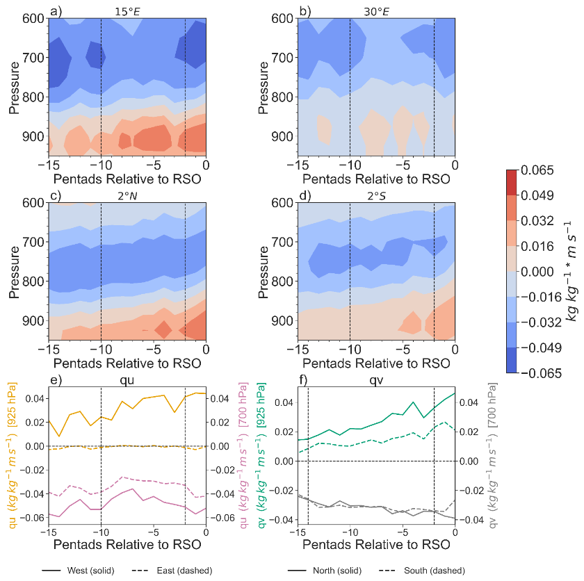
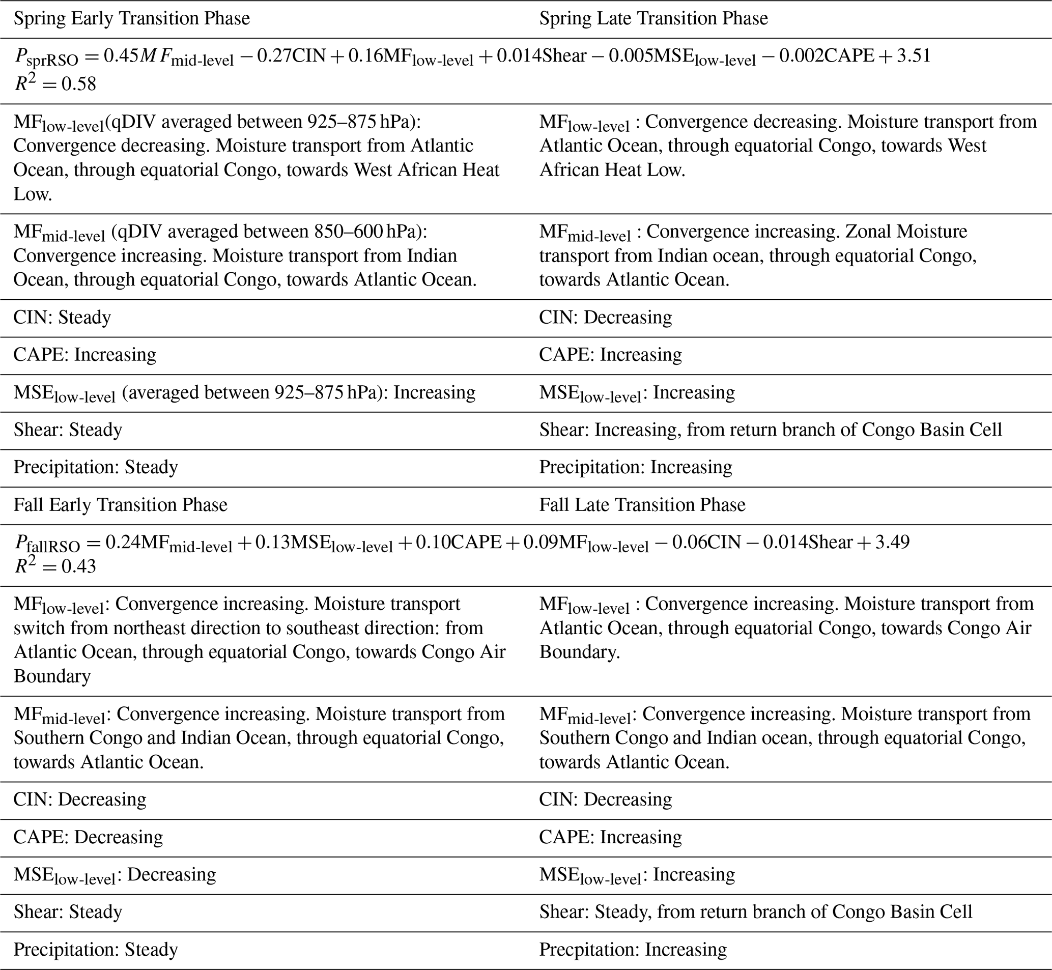
Figure B1(a) Zonal moisture transport (q⋅u) across 15° E and between 2° S–2° N; (b) zonal moisture transport (q⋅v) across 30° E and between 2° S–2° N. Note that contours below 875 hPa should not be considered as they are below the East African Rift, but all pressure levels are shown to emphasize the mid-level moisture transport. (c) meridional moisture transport (q⋅v) across 2° N and between 15–30° E; (d) meridional moisture transport (q⋅v) across 2° S and between 15–30° E; (e) zonal moisture transport at 925 hPa (orange) and 700 hPa (purple) across the western and eastern boundaries; and (f) meridional moisture transport at 925 hPa (green) and 700 hPa (grey) across the northern and southern boundaries. For (a) and (b), positive values equal eastward transport and negative equal westward transport. For (c) and (d), positive equals northward transport and negative values equal southward transport. Additionally, for longitude values greater than 26° E, meridional moisture transport values have been masked out between 925–875 hPa to account for the topography of the East African Rift. Therefore, shades below 875 hPa represent meridional moisture transport between 15–26° E Prior to the spring RSO.
Figure B2(a) zonal moisture transport (q⋅u) across 15° E and between 2° S–2° N; (b) zonal moisture transport (q⋅v) across 30° E and between 2° S–2° N. Note that contours below 875 hPa should not be considered as they are below the East African Rift, but all pressure levels are shown to emphasize the mid-level moisture transport. (c) meridional moisture transport (q⋅v) across 2° N and between 15–30° E; and (d) meridional moisture transport (q⋅v) across 2° S and between 15–30° E; (e) zonal moisture transport at 925 hPa (orange) and 700 hPa (purple) across the western and eastern boundaries; and (f) meridional moisture transport at 925 hPa (green) and 700 hPa (grey) across the northern and southern boundaries. For (a) and (b), positive values equal eastward transport and negative values equal westward transport. For (c) and (d), positive values equal northward transport and negative values equals southward transport. Additionally, for longitude values greater than 26° E, meridional moisture transport values have been masked out between 925–875 hPa to account for the topography of the East African Rift. Therefore, shades below 875 hPa represent meridional moisture transport between 15–26° E Prior to the fall RSO.
Code can be made available by request to the corresponding author (Sarah Worden, sarah.r.worden@jpl.nasa.gov).
GLEAM evapotranspiration estimates can be downloaded via the GLEAM website: https://www.gleam.eu/ (last access: 8 June 2026). Version 3.7b can be made available by request to the corresponding author Sarah Worden (sarah.r.worden@jpl.nasa.gov). All AIRS TqJoint data and TRMM 3b42 daily precipitation can be downloaded using the NASA GES DISC: https://disc.gsfc.nasa.gov (last access: 8 June 2026).
ERA5 products can be found at: https://cds.climate.copernicus.eu/datasets (last access: 8 June 2026). TES HDO and H2O estimates can be found at: https://tes.jpl.nasa.gov/tes/data/ (last access: 8 June 2026). CERES cloud and products can be found at: https://ceres.larc.nasa.gov/data/ (last access: 8 June 2026).
The supplement related to this article is available online at https://doi.org/10.5194/acp-26-8529-2026-supplement.
All authors contributed to the study conception and design. SW performed experimental design, data collection, analysis, and manuscript writing. RF performed experimental design and manuscript writing. All authors read and approved the final manuscript.
The contact author has declared that neither of the authors has any competing interests.
Publisher's note: Copernicus Publications remains neutral with regard to jurisdictional claims made in the text, published maps, institutional affiliations, or any other geographical representation in this paper. The authors bear the ultimate responsibility for providing appropriate place names. Views expressed in the text are those of the authors and do not necessarily reflect the views of the publisher.
Part of this research was carried out at the Jet Propulsion Laboratory, California Institute of Technology, under a contract with the National Aeronautics and Space Administration (grant no. 80NM0018D0004).
This research has been supported by the National Aeronautics and Space Administration (grant no. 80NSSC20K1654) and the National Science Foundation (grant no. 1917781).
This paper was edited by Zhanqing Li and reviewed by two anonymous referees.
Alsdorf, D., Beighley, E., Laraque, A., Lee, H., Tshimanga, R., O'Loughlin, F., Mahé, G., Dinga, B., Moukandi, G., and Spencer, R. G.: Opportunities for hydrologic research in the Congo Basin, Rev. Geophys., 54, 378–409, https://doi.org/10.1002/2016RG000517, 2016.
Attwood, K., Washington, R., and Munday, C.: The Southern African Heat Low: Structure, seasonal and diurnal variability, and climatological trends, J. Climate, 37, 3037–3053, https://doi.org/10.1175/JCLI-D-23-0522.1, 2024.
Aumann, H. H., Broberg, S., Manning, E., and Pagano, T.: Radiometric stability validation of 17 years of AIRS data using sea surface temperatures, Geophys. Res. Lett., 46, 12504–12510, https://doi.org/10.1029/2019GL085098, 2019.
Bailey, A., Blossey, P. N., Noone, D., Nusbaumer, J., and Wood, R.: Detecting shifts in tropical moisture imbalances with satellite-derived isotope ratios in water vapor, J. Geophys. Res. Atmos., 122(11), 5763–5779, https://doi.org/10.1002/2016JD026222, 2017.
Balas, N., Nicholson, S. E., and Klotter, D.: The relationship of rainfall variability in West Central Africa to sea-surface temperature fluctuations, Int. J. Climatol., 27, 1335–1349, https://doi.org/10.1002/joc.1456, 2007.
Biasutti, M: Rainfall trends in the African Sahel: Characteristics, processes, and causes, Wiley Interdisciplinary Reviews: Climate Change, 10(4), https://doi.org/10.1002/wcc.591, 2019.
Biasutti, M., and Sobel, A.H.: Delayed Sahel rainfall and global seasonal cycle in a warmer climate, Geophys. Res. Lett., 36, 23, https://doi.org/10.1029/2009GL041303, 2009.
Bolton, D.: The computation of equivalent potential temperature, Mon. Weather Rev., 108, 1046–1053, https://doi.org/10.1175/1520-0493(1980)108<1046:TCOEPT>2.0.CO;2, 1980.
Bretherton, C. S., Peters, M. E., and Back, L. E.: Relationships between water vapor path and precipitation over the tropical oceans, J. Climate, 17, 1517–1528, https://doi.org/10.1175/1520-0442(2004)017<1517:RBWVPA>2.0.CO;2, 2004.
Brummett, R. E., Tanania, C., Pandi, A., Ladel, J., Munzimi, Y., Russell, A. J. M., Stiassny, M., Thieme, M., White, S., and Davies, D.: Ressources en eau et biens et services liés à l'écosystème forestier, in: Les forêts du Bassin du Congo, edited by: de Wasseige, C., Devers, D., de Marcken, P., Eba'a Atyi, R., Nasi, R., and Mayaux, P., Office des publications de l'Union européenne, Luxembourg, https://doi.org/10.2788/32456, 2009.
Caniaux, G., Giordani, H., Redelsperger, J. L., Guichard, F., Key, E., and Wade, M.: Coupling between the Atlantic cold tongue and the West African monsoon in boreal spring and summer, J. Geophys. Res.-Oceans, 116, https://doi.org/10.1029/2010JC006570, 2011.
Chakraborty, S., Jiang, J. H., Su, H., and Fu, R.: Deep convective evolution from shallow clouds over the Amazon and Congo rainforests, J. Geophys. Res.-Atmos., 125, e2019JD030962, https://doi.org/10.1029/2019JD030962, 2020.
Chakraborty, S., Jiang, J. H., Su, H., and Fu, R.: On the role of aerosol radiative effect in the wet season onset timing over the Congo rainforest during boreal autumn, Atmos. Chem. Phys., 21, 12855–12866, https://doi.org/10.5194/acp-21-12855-2021, 2021.
Chen, T. C.: Maintenance of the midtropospheric North African summer circulation: Saharan high and African easterly jet, J. Climate, 18, 2943–2962, https://doi.org/10.1175/JCLI3446.1, 2005.
Cook, K. H. and Vizy, E. K.: The Congo Basin Walker circulation: Dynamics and connections to precipitation, Clim. Dynam., 47, 697–717, https://doi.org/10.1007/s00382-015-2864-y, 2016.
Cook, K. H. and Vizy, E. K.: Hydrodynamics of regional and seasonal variations in Congo Basin precipitation, Clim. Dynam., 59, 1775–1797, https://doi.org/10.1007/s00382-021-06066-3, 2022.
Cook, K. H., Liu, Y., and Vizy, E. K.: Congo Basin drying associated with poleward shifts of the African thermal lows, Clim. Dynam., 54, 863–883, https://doi.org/10.1007/s00382-019-05033-3, 2020.
Creese, A., Washington, R., and Jones, R.: Climate change in the Congo Basin: Processes related to wetting in the December–February dry season, Clim. Dynam., 53, 3583–3602, https://doi.org/10.1007/s00382-019-04728-x, 2019.
DeSouza-Machado, S., Strow, L. L., Tangborn, A., Huang, X., Chen, X., Liu, X., Wu, W., and Yang, Q.: Single-footprint retrievals for AIRS using a fast TwoSlab cloud-representation model and the SARTA all-sky infrared radiative transfer algorithm, Atmos. Meas. Tech., 11, 529–550, https://doi.org/10.5194/amt-11-529-2018, 2018.
Doelling, D. R., Loeb, N. G., Keyes, D. F., Nordeen, M. L., Morstad, D., Nguyen, C., Wielicki, B. A., Young, D. F., and Sun, M.: Geostationary Enhanced Temporal Interpolation for CERES flux products, J. Atmos. Ocean. Tech., 30, 1072–1090, https://doi.org/10.1175/JTECH-D-12-00136.1, 2013.
Doelling, D. R., Sun, M., Nguyen, L. T., Nordeen, M. L., Haney, C. O., Keyes, D. F., and Mlynczak, P. E.: Advances in geostationary-derived longwave fluxes for the CERES Synoptic (SYN1deg) product, J. Atmos. Ocean. Tech., 33, 503–521, https://doi.org/10.1175/JTECH-D-15-0147.1, 2016.
Galewsky, J., Steen‐Larsen, H. C., Field, R. D., Worden, J., Risi, C., and Schneider, M.: Stable isotopes in atmospheric water vapor and applications to the hydrologic cycle, Rev. Geophys., 54(4), 809-865, https://doi.org/10.1002/2015RG000512, 2016.
Galewsky, J.: Using stable isotopes in water vapor to diagnose relationships between lower-tropospheric stability, mixing, and low-cloud cover near the island of Hawaii, Geophys. Res. Lett., 45, 297–305, https://doi.org/10.1002/2017GL075770, 2018.
Galewsky, J. and Hurley, J. V.: An advection-condensation model for subtropical water vapor isotopic ratios, J. Geophys. Res., 115, D16116, https://doi.org/10.1029/2009JD013651, 2010.
Hersbach, H., Bell, B., Berrisford, P., Hirahara, S., Horányi, A., Muñoz-Sabater, J., Nicolas, J., Peubey, C., Radu, R., Schepers, D., Simmons, A., Soci, C., Abdalla, S., Abellan, X., Balsamo, G., Bechtold, P., Biavati, G., Bidlot, J., Bonavita, M., De Chiara, G., Dahlgren, P., Dee, D., Diamantakis, M., Dragani, R., Flemming, J., Forbes, R., Fuentes, M., Geer, A., Haimberger, L., Healy, S., Hogan, R. J., Holm, E., Janiskova, M., Keeley, S., Laloyaux, P., Lopez, P., Lupu, C., Radnoti, G., de Rosnay, P., Rozum, I., Vamborg, F., Villaume, S., and Thepaut, J.-N.: The ERA5 global reanalysis, Q. J. Roy. Meteor. Soc., 146, 1999–2049, https://doi.org/10.1002/qj.3803, 2020.
Howard, E. and Washington, R.: Characterizing the synoptic expression of the Angola low, J. Climate, 31, 7147–7165, https://doi.org/10.1175/JCLI-D-18-0017.1, 2018.
Howard, E. and Washington, R.: Drylines in southern Africa: Rediscovering the Congo air boundary, J. Climate, 32, 8223–8242, https://doi.org/10.1175/JCLI-D-19-0437.1, 2019.
Hua, W., Zhou, L., Chen, H., Nicholson, S. E., Raghavendra, A., and Jiang, Y.: Possible causes of the Central Equatorial African long-term drought, Environ. Res. Lett., 11, 124002, https://doi.org/10.1088/1748-9326/11/12/124002, 2016.
Hua, W., Zhou, L., Chen, H., Nicholson, S. E., Jiang, Y., and Raghavendra, A: Understanding the Central Equatorial African long-term drought using AMIP-type simulations, Clim. Dyn., 50(3), https://doi.org/10.1007/s00382-017-3665-2, 1115–1128, 2018.
Hua, W., Zhou, L., Nicholson, S. E., Chen, H., and Qin, M.: Assessing reanalysis data for understanding rainfall climatology and variability over Central Equatorial Africa, Clim. Dynam., 53, 651–669, https://doi.org/10.1007/s00382-018-04604-0, 2019.
Huffman, G. J., Bolvin, D. T., Nelkin, E. J., Wolff, D. B., Adler, R. F., Gu, G., Hong, Y., Bowman, K. P., and Stocker, E. F.: The TRMM multisatellite precipitation analysis (TMPA): Quasi-global, multiyear, combined-sensor precipitation estimates at fine scales, J. Hydrometeorol., 8, 38–55, https://doi.org/10.1175/JHM560.1, 2007.
Irion, F. W., Kahn, B. H., Schreier, M. M., Fetzer, E. J., Fishbein, E., Fu, D., Kalmus, P., Wilson, R. C., Wong, S., and Yue, Q.: Single-footprint retrievals of temperature, water vapor and cloud properties from AIRS, Atmos. Meas. Tech., 11, 971–995, https://doi.org/10.5194/amt-11-971-2018, 2018.
Jiang, Y., Zhou, L., Tucker, C. J., Raghavendra, A., Hua, W., Liu, Y. Y., and Joiner, J.: Widespread increase of boreal summer dry season length over the Congo rainforest, Nat. Clim. Change, 9, 617–622, https://doi.org/10.1038/s41558-019-0512-y, 2019.
Jury, M. R., Matari, E., and Matitu, M.: Equatorial African climate teleconnections, Theor. Appl. Climatol., 95, 407–416, https://doi.org/10.1007/s00704-008-0018-4, 2009.
Kebacho, L. L. and Sarfo, I.: Why Eastern Africa was not dry during the 2020 short rainy season despite La Niña and a negative Indian Ocean Dipole: Interplay between the Madden-Julian Oscillation and La Niña in modulating short rain, Theor. Appl. Climatol., 153, 1191–1201, https://doi.org/10.1007/s00704-023-04519-9, 2023.
Kenfack, K., Tamoffo, A. T., Djiotang Tchotchou, L. A., and Vondou, D. A.: Assessment of uncertainties in reanalysis datasets in reproducing thermodynamic mechanisms in the moisture budget’s provision in the Congo Basin, Theor. Appl. Climatol., 154, 613–626, https://doi.org/10.1007/s00704-023-04576-0, 2023.
Kenfack, K., Tamoffo, A. T., Tchotchou, L. A. D., Marra, F., Kaissassou, S., Nana, H. N., and Vondou, D. A.: Processes behind the decrease in Congo Basin precipitation during the rainy seasons inferred from ERA‐5 reanalysis, Int. J. Climatol., 44(5), 1778–1799, https://doi.org/10.1002/joc.8410, 2024.
Kuete, G., Pokam Mba, W., and Washington, R.: African Easterly Jet South: Control, maintenance mechanisms and link with Southern subtropical waves, Clim. Dynam., 54, 1539–1552, https://doi.org/10.1007/s00382-019-05072-w, 2020.
Lavaysse, C., Flamant, C., Janicot, S., Parker, D. J., Lafore, J. P., Sultan, B., and Pelon, J.: Seasonal evolution of the West African heat low: A climatological perspective, Clim. Dynam., 33, 313–330, https://doi.org/10.1007/s00382-009-0553-4, 2009.
Li, W. and Fu, R.: Transition of the large-scale atmospheric and land surface conditions from the dry to the wet season over Amazonia as diagnosed by the ECMWF re-analysis, J. Climate, 17, 2637–2651, https://doi.org/10.1175/1520-0442(2004)017<2637:TOTLAA>2.0.CO;2, 2004.
Longandjo, G. N. T. and Rouault, M.: On the structure of the regional-scale circulation over Central Africa: Seasonal evolution, variability, and mechanisms, J. Climate, 33, 145–162, https://doi.org/10.1175/JCLI-D-19-0176.1, 2020.
Longandjo, G. N. T. and Rouault, M.: Revisiting the seasonal cycle of rainfall over Central Africa, J. Climate, https://doi.org/10.1175/JCLI-D-23-0281.1, 2024.
Lv, S., Song, F., Dong, H., and Wu, L.: Phase and amplitude changes in rainfall annual cycle over global land monsoon regions under global warming, Geophys. Res. Lett., 51(12), e2024GL108496, https://doi.org/10.1029/2024GL108496, 2024.
Majoube, M.: Fractionnement en oxygène 18 et en deutérium entre l'eau et sa vapeur, Journal de Chimie Physique, 68, 1423–1436, https://doi.org/10.1051/jcp/1971681423, 1971.
Martens, B., Miralles, D. G., Lievens, H., van der Schalie, R., de Jeu, R. A. M., Fernández-Prieto, D., Beck, H. E., Dorigo, W. A., and Verhoest, N. E. C.: GLEAM v3: satellite-based land evaporation and root-zone soil moisture, Geosci. Model Dev., 10, 1903–1925, https://doi.org/10.5194/gmd-10-1903-2017, 2017.
Miralles, D. G., Holmes, T. R. H., De Jeu, R. A. M., Gash, J. H., Meesters, A. G. C. A., and Dolman, A. J.: Global land-surface evaporation estimated from satellite-based observations, Hydrol. Earth Syst. Sci., 15, 453–469, https://doi.org/10.5194/hess-15-453-2011, 2011.
Moihamette, F., Pokam, W. M., Diallo, I., and Washington, R.: Extreme Indian Ocean dipole and rainfall variability over Central Africa, Int. J. Climatol., 42, 5255–5272, https://doi.org/10.1002/joc.7531, 2022.
Neupane, N.: The Congo Basin zonal overturning circulation, Adv. Atmos. Sci., 33, 767–782, https://doi.org/10.1007/s00376-015-5190-8, 2016.
Nicholson, S. E.: The ITCZ and the seasonal cycle over equatorial Africa, B. Am. Meteorol. Soc., 99, 337–348, https://doi.org/10.1175/BAMS-D-16-0287.1, 2018.
Nicholson, S. E.: The rainfall and convective regime over Equatorial Africa, with emphasis on the Congo Basin, in: Congo Basin Hydrology, Climate, and Biogeochemistry, edited by: Tshimanga, R. M., N'kaya, G. D. M., and Alsdorf, D., American Geophysical Union, https://doi.org/10.1002/9781119657002.ch3, 2022.
Nicholson, S. E. and Dezfuli, A. K.: The relationship of rainfall variability in western equatorial Africa to the tropical oceans and atmospheric circulation, Part I: The boreal spring, J. Climate, 26, 45–65, https://doi.org/10.1175/JCLI-D-11-00653.1, 2013.
Nicholson, S. E. and Grist, J. P.: The seasonal evolution of the atmospheric circulation over West Africa and equatorial Africa, J. Climate, 16, 1013–1030, https://doi.org/10.1175/1520-0442(2003)016<1013:TSEOTA>2.0.CO;2, 2003.
Nicholson, S. E., Klotter, D., Zhou, L., and Hua, W.: Validation of satellite precipitation estimates over the Congo Basin, J. Hydrometeorol., 20(4), 631–656, https://doi.org/10.1175/JHM-D-18-0118, 2019.
Nicholson, S. E., and Klotter, D. A.: Assessing the reliability of satellite and reanalysis estimates of rainfall in equatorial Africa, Remote Sens., 13(18), 3609, https://doi.org/10.3390/rs13183609, 2021.
Noone, D.: Pairing measurements of the water vapor isotope ratio with humidity to deduce atmospheric moistening and dehydration in the tropical midtroposphere, J. Climate, 25, 4476–4494, https://doi.org/10.1175/JCLI-D-11-00582.1, 2012.
Pagano, T. S., Aumann, H. H., Hagan, D. E., and Overoye, K.: Prelaunch and in-flight radiometric calibration of the Atmospheric Infrared Sounder (AIRS), IEEE T. Geosci. Remote, 41, 265–273, https://doi.org/10.1109/TGRS.2002.808324, 2003.
Pokam, W., Nicholson, S., Vondou, D., Kuete, G., Longandjo, G. N., Guenang, M., Tanessong, R., Dommo, A., Tchio, T., Stella, T., Washington, R., Venkataramana, S., and Fotso-Nguemo, T.: Climate of the Congo Basin, in Resilience and Sustainability in the Congo Basin: Retracing the Past, Looking to the Future, Springer Nature Switzerland, Cham, 1–32, https://doi.org/10.1007/978-3-032-02023-9_3-2, 2026.
Pokam, W. M., Djiotang, L. A. T., and Mkankam, F. K.: Atmospheric water vapor transport and recycling in Equatorial Central Africa through NCEP/NCAR reanalysis data, Clim. Dynam., 38, 1715–1729, https://doi.org/10.1007/s00382-011-1242-7, 2012.
Pokam, W. M., Bain, C. L., Chadwick, R. S., Graham, R., Sonwa, D. J., and Kamga, F. M.: Identification of processes driving low-level westerlies in West Equatorial Africa, J. Climate, 27, 4245–4262, https://doi.org/10.1175/JCLI-D-13-00490.1, 2014.
Pokam, W. M., Vondou, D. A., and Kamsu-Tamo, P. H.: Central African climate, in: Congo Basin Hydrology, Climate, and Biogeochemistry, edited by: Tshimanga, R. M., N'kaya, G. D. M., and Alsdorf, D., American Geophysical Union, https://doi.org/10.1002/9781119657002.ch2, 2022.
Risi, C., Noone, D., Frankenberg, C., and Worden, J.: Role of continental recycling in intraseasonal variations of continental moisture as deduced from model simulations and water vapor isotopic measurements, Water Resour. Res., 49, 4136–4156, https://doi.org/10.1002/wrcr.20312, 2013.
Risi, C., Muller, C., and Blossey, P.: What controls the water vapor isotopic composition near the surface of tropical oceans? Results from an analytical model constrained by large-eddy simulations, J. Adv. Model. Earth Sy., 12, e2020MS002106, https://doi.org/10.1029/2020MS002106, 2020.
Rutan, D. A., Kato, S., Doelling, D. R., Rose, F. G., Nguyen, L. T., Caldwell, T. E., and Loeb, N. G.: CERES synoptic product: Methodology and validation of surface radiant flux, J. Atmos. Ocean. Tech., 32, 1121–1143, https://doi.org/10.1175/JTECH-D-14-00165.1, 2015.
Satyamurty, P., da Costa, C. P. W., and Manzi, A. O.: Moisture source for the Amazon Basin: A study of contrasting years, Theor. Appl. Climatol., 111, 195–209, https://doi.org/10.1007/s00704-012-0637-7, 2013.
Schiro, K. A., Ahmed, F., Giangrande, S. E., and Neelin, J. D.: GoAmazon2014/5 campaign points to deep-inflow approach to deep convection across scales, P. Natl. Acad. Sci. USA, 115, 4577–4582, https://doi.org/10.1073/pnas.1719842115, 2018.
Sorí, R., Stojanovic, M., Nieto, R., Liberato, M. L., and Gimeno, L.: Spatiotemporal variability of droughts in the Congo River Basin: The role of atmospheric moisture transport, in: Congo Basin Hydrology, Climate, and Biogeochemistry, edited by: Tshimanga, R. M., N'kaya, G. D. M., and Alsdorf, D., American Geophysical Union, https://doi.org/10.1002/9781119657002.ch11, 2022.
Su, W., Charlock, T. P., and Rose, F. G.: Deriving surface ultraviolet radiation from CERES surface and atmospheric radiation budget: Methodology, J. Geophys. Res., 110, D14209, https://doi.org/10.1029/2005JD005794, 2005.
Tchinda, A. F., Tanessong, R. S., Mamadou, O., and Orou, J. B. C.: Assessing precipitation seasonal forecasts in Central Africa using North American Multimodel Ensemble (NMME), Theor. Appl. Climatol., 147, 1309–1325, https://doi.org/10.1007/s00704-021-03915-3, 2022.
Thorncroft, C. D., Nguyen, H., Zhang, C., and Peyrillé, P.: Annual cycle of the West African monsoon: Regional circulations and associated water vapour transport, Q. J. Roy. Meteor. Soc., 137, 129–147, https://doi.org/10.1002/qj.728, 2011.
Tremoy, G., Vimeux, F., Soumana, S., Souley, I., Risi, C., Favreau, G., and Oï, M.: Clustering mesoscale convective systems with laser-based water vapor δ18O monitoring in Niamey (Niger), J. Geophys. Res., 119, 5079–5103, https://doi.org/10.1002/2013JD020968, 2014.
van der Ent, R. J., Savenije, H. H. G., Schaefli, B., and Steele-Dunne, S. C.: Origin and fate of atmospheric moisture over continents, Water Resour. Res., 46, W09525, https://doi.org/10.1029/2010WR009127, 2010.
Vizy, E. K., and Cook, K. H: Observed relationship between the Turkana low-level jet and boreal summer convection, Clim. Dyn,, 53(7), 4037–4058, https://doi.org/10.1007/s00382-019-04769-2, 2019.
Vondou, D. A., Nzeukou, A., Lenouo, A., and Mkankam Kamga, F.: Seasonal variations in the diurnal patterns of convection in Cameroon–Nigeria and their neighboring areas, Atmos. Sci. Lett., 11, 290–300, https://doi.org/10.1002/asl.297, 2010.
Washington, R., James, R., Pearce, H., Pokam, W. M., and Moufouma-Okia, W.: Congo Basin rainfall climatology: Can we believe the climate models?, Philos. T. R. Soc. B, 368, 20120296, https://doi.org/10.1098/rstb.2012.0296, 2013.
Worden, J., Noone, D., Bowman, K., Beer, R., Eldering, A., Fisher, B., Gunson, M., Goldman, A., Herman, R., Kulawik, S. S., Lampel, M., Osterman, G., Rinsland, C., Rodgers, C., Sander, S., Shephard, M., Webster, C. R., and Worden, H.: Importance of rain evaporation and continental convection in the tropical water cycle, Nature, 445, 528–532, https://doi.org/10.1038/nature05508, 2007.
Worden, J., Kulawik, S., Frankenberg, C., Payne, V., Bowman, K., Cady-Peirara, K., Wecht, K., Lee, J.-E., and Noone, D.: Profiles of CH4, HDO, H2O, and N2O with improved lower tropospheric vertical resolution from Aura TES radiances, Atmos. Meas. Tech., 5, 397–411, https://doi.org/10.5194/amt-5-397-2012, 2012.
Worden, J., Saatchi, S., Keller, M., Bloom, A. A., Liu, J., Parazoo, N., Fisher, J. B., Bowman, K., Reager, J. T., Fahy, K., Schimel, D., Fu, R., Worden, S., Yin, Y., Gentine, P., Konings, A. G., Quetin, G. R., Williams, M., Worden, H., Shi, M., and Barkhordarian, A.: Satellite observations of the tropical terrestrial carbon balance and interactions with the water cycle during the 21st century, Rev. Geophys., 59, e2020RG000711, https://doi.org/10.1029/2020RG000711, 2021a.
Worden, S., Fu, R., Chakraborty, S., Liu, J., and Worden, J.: Where does moisture come from over the Congo Basin?, J. Geophys. Res.-Biogeo., 126, e2020JG006024, https://doi.org/10.1029/2020JG006024, 2021b.
Worden, S. and Fu, R.: On the mechanisms that control the rainy season transition period in the southern Congo Basin, Clim. Dynam., 63, 157, https://doi.org/10.1007/s00382-025-07640-9, 2025.
Wright, J. S., Fu, R., Worden, J. R., Chakraborty, S., Clinton, N. E., Risi, C., Sun, Y., and Yin, L.: Rainforest-initiated wet season onset over the southern Amazon, P. Natl. Acad. Sci. USA, 114, 8481–8486, https://doi.org/10.1073/pnas.1621516114, 2017.
Xu, L., Saatchi, S. S., Yang, Y., Yu, Y., Pongratz, J., Bloom, A. A., Bowman, K., Worden, J., Liu, J., Yin, Y., Domke, G., McRoberts, R. E., Woodall, C., Nabuurs, G. J., De-Miguel, S., Keller, M., Harris, N., Maxwell, S., and Schimel, D.: Changes in global terrestrial live biomass over the 21st century, Sci. Adv., 7, eabe9829, https://doi.org/10.1126/sciadv.abe9829, 2021.
Yang, W., Seager, R., Cane, M. A., and Lyon, B.: The annual cycle of East African precipitation, J. Climate, 28, 2385–2404, https://doi.org/10.1175/JCLI-D-14-00484.1, 2015.
Zampieri, M., Toreti, A., Meroni, M., Bojovic, D., Octenjak, S., Marcos-Matamoros, R., Materia, S., Chang'a, L., Merchades, M., Chaves Montero, M. del M., Rembold, F., Troccoli, A., Roy, I., and Hoteit, I.: Seasonal forecasts of the rainy season onset over Africa: Preliminary results from the FOCUS-Africa project, Climate Services, 32, 100417, https://doi.org/10.1016/j.cliser.2023.100417, 2023.
Zhou, L., Tian, Y., Myneni, R. B., Ciais, P., Saatchi, S., Liu, Y. Y., Piao, S., Chen, H., Vermote, E. F., Song, C., and Hwang, T.: Widespread decline of Congo rainforest greenness in the past decade, Nature, 508, 86–90, https://doi.org/10.1038/nature13265, 2014.