Articles | Volume 26, issue 16
https://doi.org/10.5194/acp-26-11645-2026
© Author(s) 2026. This work is distributed under
the Creative Commons Attribution 4.0 License.
https://doi.org/10.5194/acp-26-11645-2026
© Author(s) 2026. This work is distributed under
the Creative Commons Attribution 4.0 License.
Radar data shows graupel and increased turbulence near small-scale intermittent lightning discharges at the top of intense thunderstorms
Reinaart van Loon
CORRESPONDING AUTHOR
Royal Netherlands Meteorological Institute, De Bilt, The Netherlands
currently at: Wageningen University & Research (WUR), Wageningen, The Netherlands
Jelle D. Assink
Royal Netherlands Meteorological Institute, De Bilt, The Netherlands
Olaf Scholten
University Groningen, Kapteyn Astronomical Institute, Groningen, The Netherlands
Netherlands Institute of Radio Astronomy (ASTRON), Dwingeloo, The Netherlands
Brian M. Hare
University Groningen, Kapteyn Astronomical Institute, Groningen, The Netherlands
Netherlands Institute of Radio Astronomy (ASTRON), Dwingeloo, The Netherlands
Hidde Leijnse
Royal Netherlands Meteorological Institute, De Bilt, The Netherlands
Aarnout J. van Delden
Institute of Marine & Atmospheric Research Utrecht, Utrecht University, The Netherlands
Related authors
No articles found.
Aart Overeem, Hidde Leijnse, Mats Veldhuizen, and Bastiaan Anker
Earth Syst. Sci. Data, 17, 4715–4736, https://doi.org/10.5194/essd-17-4715-2025, https://doi.org/10.5194/essd-17-4715-2025, 2025
Short summary
Short summary
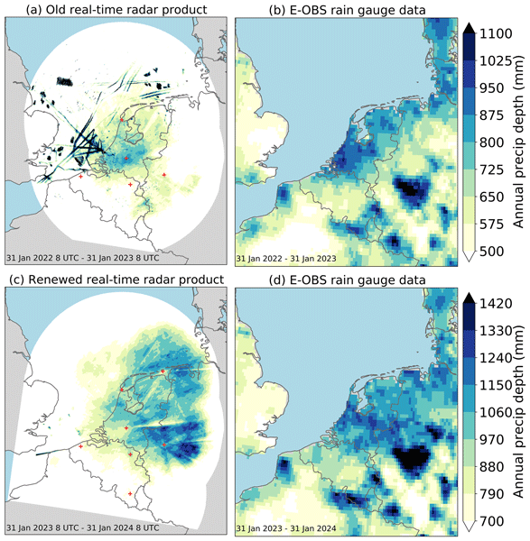
The Dutch real-time gauge-adjusted radar product provides 5 min precipitation accumulations every 5 min covering the Netherlands and the area around it. It plays a key role in hydrological decision-support systems and as input for short-term weather forecasts. Major changes were implemented on 31 January 2023, and the associated quality improvement is presented. Moreover, the employed radar and rain gauge datasets and the algorithms needed to produce this real-time radar product are described.
Arthur Merlijn Oldeman, Michiel L. J. Baatsen, Anna S. von der Heydt, Aarnout J. van Delden, and Henk A. Dijkstra
Weather Clim. Dynam., 5, 395–417, https://doi.org/10.5194/wcd-5-395-2024, https://doi.org/10.5194/wcd-5-395-2024, 2024
Short summary
Short summary
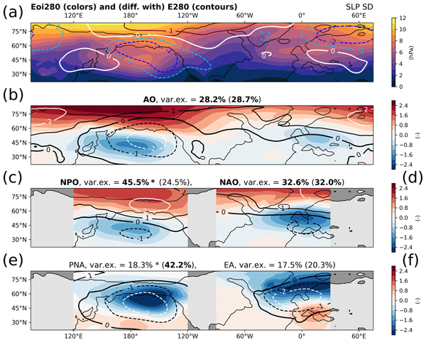
The mid-Pliocene, a geological period around 3 million years ago, is sometimes considered the best analogue for near-future climate. It saw similar CO2 concentrations to the present-day but also a slightly different geography. In this study, we use climate model simulations and find that the Northern Hemisphere winter responds very differently to increased CO2 or to the mid-Pliocene geography. Our results weaken the potential of the mid-Pliocene as a future climate analogue.
Aart Overeem, Hidde Leijnse, Gerard van der Schrier, Else van den Besselaar, Irene Garcia-Marti, and Lotte Wilhelmina de Vos
Hydrol. Earth Syst. Sci., 28, 649–668, https://doi.org/10.5194/hess-28-649-2024, https://doi.org/10.5194/hess-28-649-2024, 2024
Short summary
Short summary
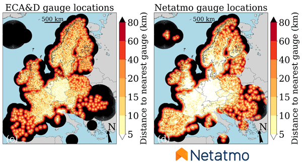
Ground-based radar precipitation products typically need adjustment with rain gauge accumulations to achieve a reasonable accuracy. Crowdsourced rain gauge networks have a much higher density than conventional ones. Here, a 1-year personal weather station (PWS) gauge dataset is obtained. After quality control, the 1 h PWS gauge accumulations are merged with pan-European radar accumulations. The potential of crowdsourcing to improve radar precipitation products in (near) real time is confirmed.
Linda Bogerd, Hidde Leijnse, Aart Overeem, and Remko Uijlenhoet
Atmos. Meas. Tech., 17, 247–259, https://doi.org/10.5194/amt-17-247-2024, https://doi.org/10.5194/amt-17-247-2024, 2024
Short summary
Short summary
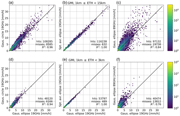
Algorithms merge satellite radiometer data from various frequency channels, each tied to a different footprint size. We studied the uncertainty associated with sampling (over the Netherlands using 4 years of data) as precipitation is highly variable in space and time by simulating ground-based data as satellite footprints. Though sampling affects precipitation estimates, it doesn’t explain all discrepancies. Overall, uncertainties in the algorithm seem more influential than how data is sampled.
Jasper de Jong, Michiel L. J. Baatsen, and Aarnout J. van Delden
EGUsphere, https://doi.org/10.5194/egusphere-2023-1259, https://doi.org/10.5194/egusphere-2023-1259, 2023
Preprint archived
Short summary
Short summary
Tropical cyclones often embed a ring-shaped vorticity tower, instead of a centre maximum. Inspired to identify mechanisms in the conservation of such a vorticity structure, we examined the vorticity budget in a simulation of hurricane Irma (2017) near lifetime-peak intensity. Hurricane Irma persisted as a category five hurricane for three consecutive days. We find that vertical exchange of momentum by diabatic heating compensates the advective vorticity loss and eddy activity plays a minor role.
Aart Overeem, Else van den Besselaar, Gerard van der Schrier, Jan Fokke Meirink, Emiel van der Plas, and Hidde Leijnse
Earth Syst. Sci. Data, 15, 1441–1464, https://doi.org/10.5194/essd-15-1441-2023, https://doi.org/10.5194/essd-15-1441-2023, 2023
Short summary
Short summary
EURADCLIM is a new precipitation dataset covering a large part of Europe. It is based on weather radar data to provide local precipitation information every hour and combined with rain gauge data to obtain good precipitation estimates. EURADCLIM provides a much better reference for validation of weather model output and satellite precipitation datasets. It also allows for climate monitoring and better evaluation of extreme precipitation events and their impact (landslides, flooding).
Wagner Wolff, Aart Overeem, Hidde Leijnse, and Remko Uijlenhoet
Atmos. Meas. Tech., 15, 485–502, https://doi.org/10.5194/amt-15-485-2022, https://doi.org/10.5194/amt-15-485-2022, 2022
Short summary
Short summary
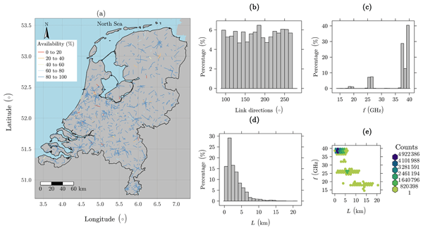
The existing infrastructure for cellular communication is promising for ground-based rainfall remote sensing. Rain-induced signal attenuation is used in dedicated algorithms for retrieving rainfall depth along commercial microwave links (CMLs) between cell phone towers. This processing is a source of many uncertainties about input data, algorithm structures, parameters, CML network, and local climate. Application of a stochastic optimization method leads to improved CML rainfall estimates.
Cited articles
Al-Sakka, H., Boumahmoud, A.-A., Fradon, B., Frasier, S. J., and Tabary, P.: A new fuzzy logic hydrometeor classification scheme applied to the French X-, C-, and S-band polarimetric radars, J. Appli. Meteorol. Climat., 52, 2328–2344, 2013. a
Crameri, F.: Scientific colour maps, https://zenodo.org/records/8409685 (last access: 22 June 2026), 2023. a
Dolan, B., Rutledge, S. A., Lim, S., Chandrasekar, V., and Thurai, M.: A robust C-band hydrometeor identification algorithm and application to a long-term polarimetric radar dataset, J. Appl. Meteorol. Climat., 52, 2162–2186, 2013. a
Fuchs, B. R., Bruning, E. C., Rutledge, S. A., Carey, L. D., Krehbiel, P. R., and Rison, W.: Climatological analyses of LMA data with an open-source lightning flash-clustering algorithm, J. Geophys. Res.: Atmos., 121, 8625–8648, 2016. a
Gideon, R. A. and Mueller, D. E.: Computation of the two-sample Smirnov statistics, Am. Stat., 32, 136–137, 1978. a
Hare, B. M., Scholten, O., Bonardi, A., Buitink, S., Corstanje, A., Ebert, U., Falcke, H., Hörandel, J. R., Leijnse, H., Mitra, P., Mulrey, K., Nelles, A., Rachen, J. P., Rossetto, L., Rutjes, C., Schellart, P., Thoudam, S., Trinh, T. N. G., ter Veen, S., and Winchen, T.: LOFAR lightning imaging: Mapping lightning with nanosecond precision, J. Geophys. Res.: Atmos., 123, 2861–2876, 2018. a, b
Heistermann, M., Jacobi, S., and Pfaff, T.: Technical Note: An open source library for processing weather radar data (wradlib), Hydrol. Earth Syst. Sci., 17, 863–871, https://doi.org/10.5194/hess-17-863-2013, 2013. a, b, c
Hersbach, H., Bell, B., Berrisford, P., Biavati, G., Horányi, A., Muñoz Sabater, J., Nicolas, J., Peubey, C., Radu, R., Rozum, I., Schepers, D., Simmons, A., Soci, C., Dee, D., and Thépaut, J.-N.: ERA5 hourly data on single levels from 1940 to present, Copernicus Climate Change Service (C3S) Climate Data Store (CDS) [data set], 10, https://doi.org/10.24381/cds.adbb2d47, 2023. a, b, c, d
Holmlund, K., Grandell, J., Schmetz, J., Stuhlmann, R., Bojkov, B., Munro, R., Lekouara, M., Coppens, D., Viticchie, B., August, T., Theodore, B., Watts, P., Dobber, M., Fowler, G., Bojinski, S., Schmid, A., Salonen, K., Tjemkes, S., Aminou, D., and Blythe, P.: Meteosat Third Generation (MTG): Continuation and innovation of observations from geostationary orbit, B. Am. Meteorol. Soc., 102, E990–E1015, 2021. a
Kumjian, M. R.: Principles and Applications of Dual-Polarization Weather Radar, Part I: Description of the Polarimetric Radar Variables, J. Oper. Meteor., 1, https://doi.org/10.15191/nwajom.2013.0119, 2013a. a, b
Kumjian, M. R.: Principles and Applications of Dual-Polarization Weather Radar, Part II: Warm-and Cold-Season Applications, J. Oper. Meteor., 1, https://doi.org/10.15191/nwajom.2013.0120, 2013b. a, b
Lakshmanan, V. and Witt, A.: Detection of bounded weak echo regions in meteorological radar images, in: Proceedings of 13th International Conference on Pattern Recognition, 3, 895–899, IEEE, 1996. a
Liu, N. Y., Scholten, O., Hare, B. M., Dwyer, J. R., Sterpka, C. F., Kolmašová, I., and Santolík, O.: LOFAR observations of lightning initial breakdown pulses, Geophys. Res. Lett., 49, e2022GL098073, https://doi.org/10.1029/2022GL098073, 2022. a
Mak, H. Y. L. and Unal, C.: Peering into the heart of thunderstorm clouds: insights from cloud radar and spectral polarimetry, Atmos. Meas. Tech., 18, 1209–1242, https://doi.org/10.5194/amt-18-1209-2025, 2025. a
Mareev, E. A. and Dementyeva, S. O.: The role of turbulence in thunderstorm, snowstorm, and dust storm electrification, J. Geophys. Res.: Atmos., 122, 6976–6988, 2017. a
Markowski, P. and Richardson, Y.: Mesoscale meteorology in midlatitudes, John Wiley & Sons, https://doi.org/10.1002/9780470682104, 2011. a, b, c, d
Meissel, K. and Yao, E. S.: Using Cliff’s delta as a non-parametric effect size measure: an accessible web app and R tutorial, Pract. Assess. Res. Eval., 29, https://doi.org/10.7275/pare.1977, 2024. a
Musil, D. J., Heymsfield, A. J., and Smith, P. L.: Microphysical characteristics of a well-developed weak echo region in a High Plains supercell thunderstorm, J. Appl. Meteorol. Climat., 25, 1037–1051, 1986. a
Overeem, A., Uijlenhoet, R., and Leijnse, H.: Full-year evaluation of nonmeteorological echo removal with dual-polarization fuzzy logic for two C-band radars in a temperate climate, J. Atmos. Ocean. Technol., 37, 1643–1660, 2020. a
Pedregosa, F., Pedregosa, F., Varoquaux, G., Varoquaux, G., Org, N., Gramfort, A., Gramfort, A., Michel, V., Michel, V., Fr, L., Thirion, B., Thirion, B., Grisel, O., Grisel, O., Blondel, M., Prettenhofer, P., Prettenhofer, P., Weiss, R., Dubourg, V., Dubourg, V., Vanderplas, J., Passos, A., Tp, A., and Cournapeau, D.: Scikit-learn: Machine learning in Python, J. Mach. Learn. Res., 12, 2825–2830, 2011. a
Scholten, O., Hare, B. M., Dwyer, J., Liu, N., Sterpka, C., Buitink, S., Corstanje, A., Falcke, H., Huege, T., Hörandel, J. R., Krampah, G. K., Mitra, P., Mulrey, K., Nelles, A., Pandya, H., Rachen, J. P., Trinh, T. N. G., ter Veen, S., Thoudam, S., and Winchen, T.: Distinguishing features of high altitude negative leaders as observed with LOFAR, Atmos. Res., 260, 105688, https://doi.org/10.1016/j.atmosres.2021.105688, 2021a. a, b
Scholten, O., Hare, B., Dwyer, J., Liu, N., Sterpka, C., Buitink, S., Huege, T., Nelles, A., and ter Veen, S.: Time resolved 3D interferometric imaging of a section of a negative leader with LOFAR, Phys. Rev. D, 104, 063022, 2021b. a
Scholten, O., Hare, B. M., Dwyer, J., Liu, N., Sterpka, C., Kolmašová, I., Santolík, O., Lán, R., Uhlíř, L., Buitink, S., Corstanje, A., Falcke, H., Huege, T., Hörandel, J. R., Krampah, G. K., Mitra, P., Mulrey, K., Nelles, A., Pandya, H., Rachen, J. P., Trinh, T. N. G., ter Veen, S., Thoudam, S., and Winchen, T.: A distinct negative leader propagation mode, Sci. Rep., 11, 16256, https://doi.org/10.1038/s41598-021-95433-5, 2021c. a
Scholten, O., Hare, B. M., Dwyer, J., Sterpka, C., Kolmašová, I., Santolík, O., Lán, R., Uhlíř, L., Buitink, S., Corstanje, A., Falcke, H., Huege, T., Hörandel, J. R., Krampah, G. K., Mitra, P., Mulrey, K., Nelles, A., Pandya, H., Pel, A., Rachen, J. P., Trinh, T. N. G., ter Veen, S., Thoudam, S., and Winchen, T.: The initial stage of cloud lightning imaged in high-resolution, J. Geophys. Res.: Atmos., 126, e2020JD033126, https://doi.org/10.1029/2020JD033126, 2021d. a
Scholten, O., Hare, B. M., Dwyer, J., Liu, N., Sterpka, C., Assink, J., Leijnse, H., and Veen, S. T.: Small-Scale Discharges Observed Near the Top of a Thunderstorm, Geophys. Res. Lett., 50, e2022GL101304, https://doi.org/10.1029/2022GL101304, 2023. a, b, c, d
Straka, J. M., Zrnić, D. S., and Ryzhkov, A. V.: Bulk hydrometeor classification and quantification using polarimetric radar data: Synthesis of relations, J. Appl. Meteorol. Climat., 39, 1341–1372, 2000. a
Ushio, T., Heckman, S. J., Christian, H. J., and Kawasaki, Z.-I.: Vertical development of lightning activity observed by the LDAR system: Lightning bubbles, J. Appl. Meteorol., 42, 165–174, 2003. a
van Haarlem, M. P., Wise, M. W., Gunst, A., et al.: LOFAR: The low-frequency array, Astron. Astrophys., 556, A2, https://doi.org/10.1051/0004-6361/201220873, 2013. a
van Loon, R.: Research code, Zenodo [code], https://doi.org/10.5281/zenodo.20553864, 2026. a
van Loon, R., Hare, B., and Scholten, O.: LOFAR and Borkum radar data for the June 18, 2021 thunderstorms, Zenodo [data], https://doi.org/10.5281/zenodo.17778996, 2025.
Vulpiani, G., Montopoli, M., Passeri, L. D., Gioia, A. G., Giordano, P., and Marzano, F. S.: On the use of dual-polarized C-band radar for operational rainfall retrieval in mountainous areas, J. Appl. Meteorol. Climatol., 51, 405–425, 2012a. a
Vulpiani, G., Montopoli, M., Passeri, L. D., Gioia, A. G., Giordano, P., and Marzano, F. S.: On the use of dual-polarized C-band radar for operational rainfall retrieval in mountainous areas, J. Appl. Meteorol. Climatol., 51, 405–425, 2012b.
Wang, Y. and Chandrasekar, V.: Algorithm for estimation of the specific differential phase, J. Atmos. Ocean. Technol., 26, 2565–2578, 2009.
(wradlib): 2-dimensional membership functions for C-band hydrometeor classification, GitHub [data set], https://github.com/wradlib/wradlib-data/blob/main/data/misc/msf_cband_v2.nc (last access: 19 October 2023), 2024. a
Zrnić, D. S., Ryzhkov, A., Straka, J., Liu, Y., and Vivekanandan, J.: Testing a procedure for automatic classification of hydrometeor types, J. Atmos. Ocean. Technol., 18, 892–913, 2001. a
Short summary
Comparing weather radar to high resolution lightning images, we try to learn about sparkles; small-scale lightning that flash intermittently in the top of intense thunderstorms. Near sparkles, the radar data shows much turbulence and a particular type of ice particles, called graupel. The findings support previous hypotheses regarding the physics of sparkles. Perhaps the combination of graupel and enhanced turbulence leads to small pockets of charge, which explains the small extent of sparkles.
Comparing weather radar to high resolution lightning images, we try to learn about sparkles;...
Altmetrics
Final-revised paper
Preprint